Install
Rondebosch, Western Cape, South Africa Weather
Current conditions
Observed at Capetown Intl · 1 hr ago
Forecast
10-day-
Friday
Partly cloudy. High 22°.
-
Friday Night
Cloudy. Low 12°.
-
Saturday
Cloudy. High 22°.
MET Norway forecast updated 2 hrs ago.
Hourly
Hourly forecast- Now13°
- 04:0013°
- 05:0012°
- 06:0012°
- 07:0014°
- 08:0016°
- 09:0018°
- 10:0020°
- 11:0021°
- 12:0022°
- 13:0022°
- 14:0022°
- 15:0021°
- 16:0020°
- 17:0020°
- 18:0019°
- 19:0017°
- 20:0016°
- 21:0016°
- 22:0016°
- 23:0015°
- Sat00:0016°
- 01:0016°
- 02:0016°
Daily forecast
DetailsRadar
Full mapWeather news near Rondebosch
More weather news-
 WEATHER: Pretoria to hit 35°C on Friday as Johannesburg reaches 31°C and Cape Town stays mild
22 October 2026 06:21 Sundowns treat Williete SC clash as a final in CAF Champions League battle 22 October 2026 06:07 SAPS must ensure elections are conducted in a safe environment: Cachalia 22 October 2026 06:06…
-
 WEATHER TODAY: Heat wave in Limpopo’s Western Bushveld, slight rain for Cape Town
Home » News » Weather » WEATHER TODAY: Heat wave in Limpopo’s Western Bushveld, slight rain for Cape Town Weather for Wednesday: Richards Bay climbs to 36°C and Musina to 35°C, while Gauteng, the Free State and North…
-
 WEATHER: Heatwave conditions in Pretoria and Johannesburg as Cape Town braces for morning rain on Thursday
21 October 2026 14:12 MTBPS 2026: Godongwana directs millions to Commission Inquiries 21 October 2026 14:05 Fannie Masemola vows to quickly replace disgraced former deputy Shadrack Sibiya 21 October 2026 14:00 Hyron…
-
 Brace for rain and strong winds in Western Cape
Home » News » Weather » Brace for rain and strong winds in Western Cape The Western Cape can expect rain and cooler weather on Wednesday, while several inland provinces remain hot and windy. The Western Cape can expect…
-
 WEATHER: Hot in Gauteng, rainy and windy in Cape Town on Wednesday
20 October 2026 08:59 Sibiya knew he was committing a crime when allegedly sexually grooming minor: Court 20 October 2026 08:57 Extortion case against Joe Sibanyoni and co-accused postponed to April 20 October 2026…
-
 Periods of rain and strong winds – Wednesday weather forecast
Today’s weather in Cape Town will bring periods of rain, with a high of 18°C and a low of 13°C. The UV index will reach a moderate level of 3. Expect around 94% cloud cover during the day, with a northwesterly wind…
-
 Tuesday Weather: Damaging Wave Warning Issued for KwaZulu-Natal Coast as Cape Town Braces for Rain
South Africa wakes up to a mixed bag of conditions this Tuesday, 20 October 2026, with warm sunshine in some provinces and grey, wet skies in others. Here is a full breakdown of what to expect, province by province…
- Why one part of South Africa is sweltering while another is freezing
This is why South Africa can be hot in one province and cold in another. As recent weather shows, South Africans can experience dramatically different weather conditions on the same day, with one province melting in hot…
-
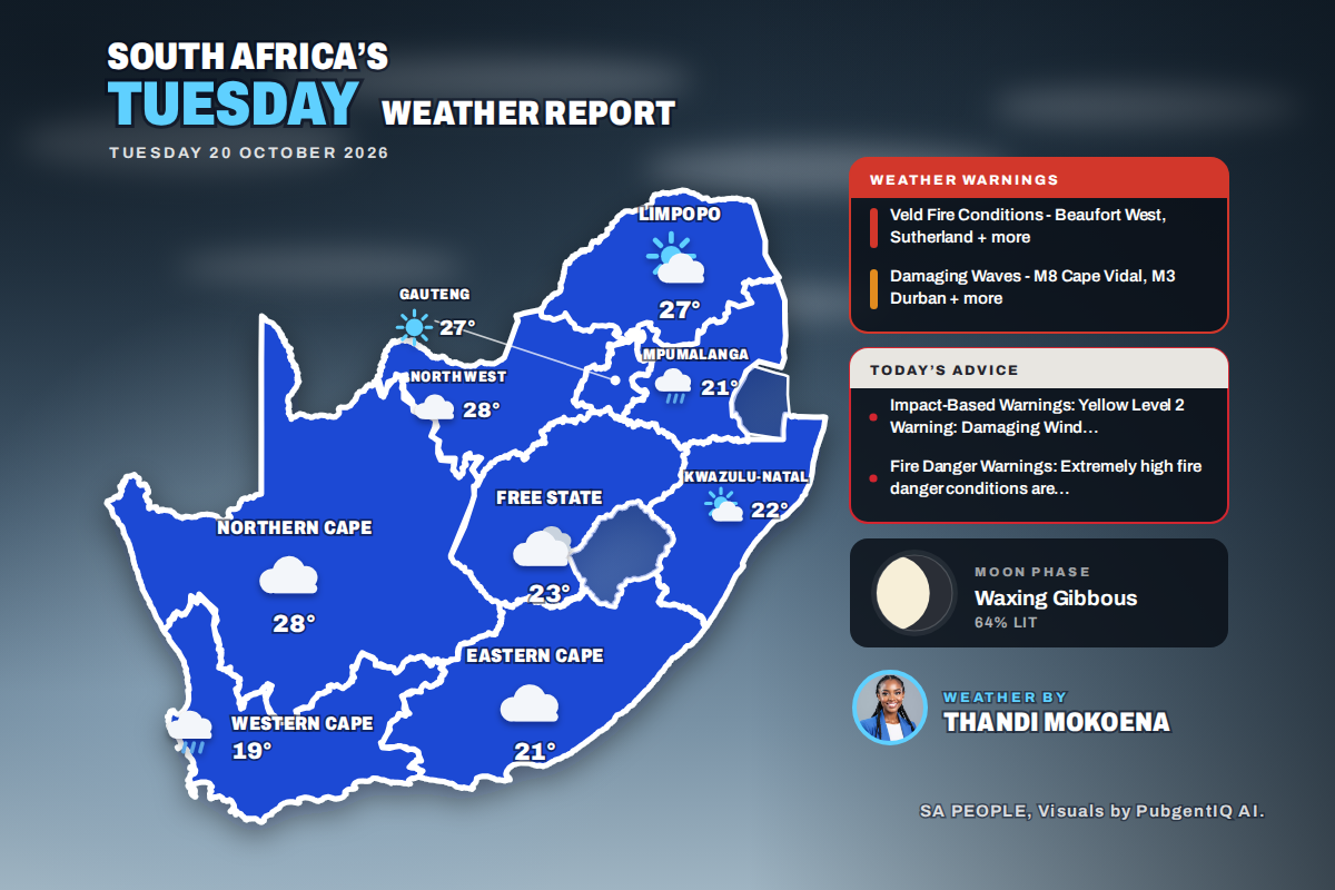 Here is today’s weather by province: Damaging waves expected along the KwaZulu-Natal coast today
Home » Here is today’s weather by province: Damaging waves expected along the KwaZulu-Natal coast today Mahikeng swings from a chilly 6°C at dawn to the country’s warmest reading of 28°C, while Cape Town tops out at…
-
 A damp and dreary day ahead - Tuesday weather forecast
Today’s weather in Cape Town features solid cloud cover with a couple of showers this afternoon, with a high of 18°C and a low of 13°C. Expect a grey day with some wet spells to keep things interesting. The UV index…
Sun & moon
Nearby
- Cape Town 6 km
- Paarl 53 km
- Somerset West 34 km
- Stellenbosch 36 km
- Atlantis 44 km
- Kraaifontein 26 km
- Durbanville 22 km
- Kuils River 21 km
- Grabouw 54 km
- Muizenberg 15 km
- Retreat 10 km
- Franschhoek 60 km
Forecasts, observations and alerts in the United States come from the National Weather Service (NOAA); radar from NOAA's Multi-Radar Multi-Sensor system; satellite imagery from NASA's Global Imagery Browse Services (GIBS) and NOAA's GOES satellites; the map from the U.S. Geological Survey's National Map; air quality from AirNow (EPA and its partners); hurricane information from the National Hurricane Center; climate normals and records from NOAA's Regional Climate Centers (ACIS). Forecasts outside the United States and the UV index: MET Norway (CC BY 4.0); observations outside the U.S.: airport reports via NOAA's Aviation Weather Center. Place names: GeoNames (CC BY 4.0). Data are copied on a schedule and may lag the sources; for warnings that affect your safety, follow your local National Weather Service office and emergency officials. Weather news is drawn from the 4Search index and reflects what the press published. Terms of use.