Install
White Sulphur Springs, WV Weather
Current conditions
Forecast for this hour (no station report in the last two hours)
Forecast
10-day-
Tonight
Partly cloudy, with a low around 35. Northwest wind 0 to 3 mph.
-
Tuesday
Patchy fog between 8am and 9am. Sunny, with a high near 70. East wind 0 to 5 mph.
-
Tuesday Night
Patchy fog after 2am. Partly cloudy, with a low around 42. Southeast wind around 3 mph.
National Weather Service forecast updated 6 hrs ago.
Hourly
Hourly forecast- Now49°
- 10 PM47°
- 11 PM45°
- Tue12 AM44°
- 1 AM42°
- 2 AM41°
- 3 AM40°
- 4 AM39°
- 5 AM38°
- 6 AM37°
- 7 AM37°
- 8 AM37°
- 9 AM40°
- 10 AM50°
- 11 AM57°
- 12 PM62°
- 1 PM66°
- 2 PM68°
- 3 PM69°
- 4 PM70°
- 5 PM68°
- 6 PM64°
- 7 PM60°
- 8 PM54°
10-day forecast
Details- TodayOct 26Sunny35°68°
- TueOct 27Patchy Fog then Sunny42°70°
- WedOct 28Mostly Cloudy43°66°
- ThuOct 29Mostly Sunny41°72°
- FriOct 30Sunny45°74°
- SatOct 31Mostly Cloudy18%48°69°
- SunNov 1Chance Rain Showers44%51°65°
- MonNov 2Light rain0.16 in56°65°
- TueNov 3Cloudy58°72°
- WedNov 4Light rain0.07 in58°72°
Days after the National Weather Service's seven are MET Norway's outlook, a computer model with no forecaster's review.
Radar
Full mapWeather news in West Virginia
More weather news-
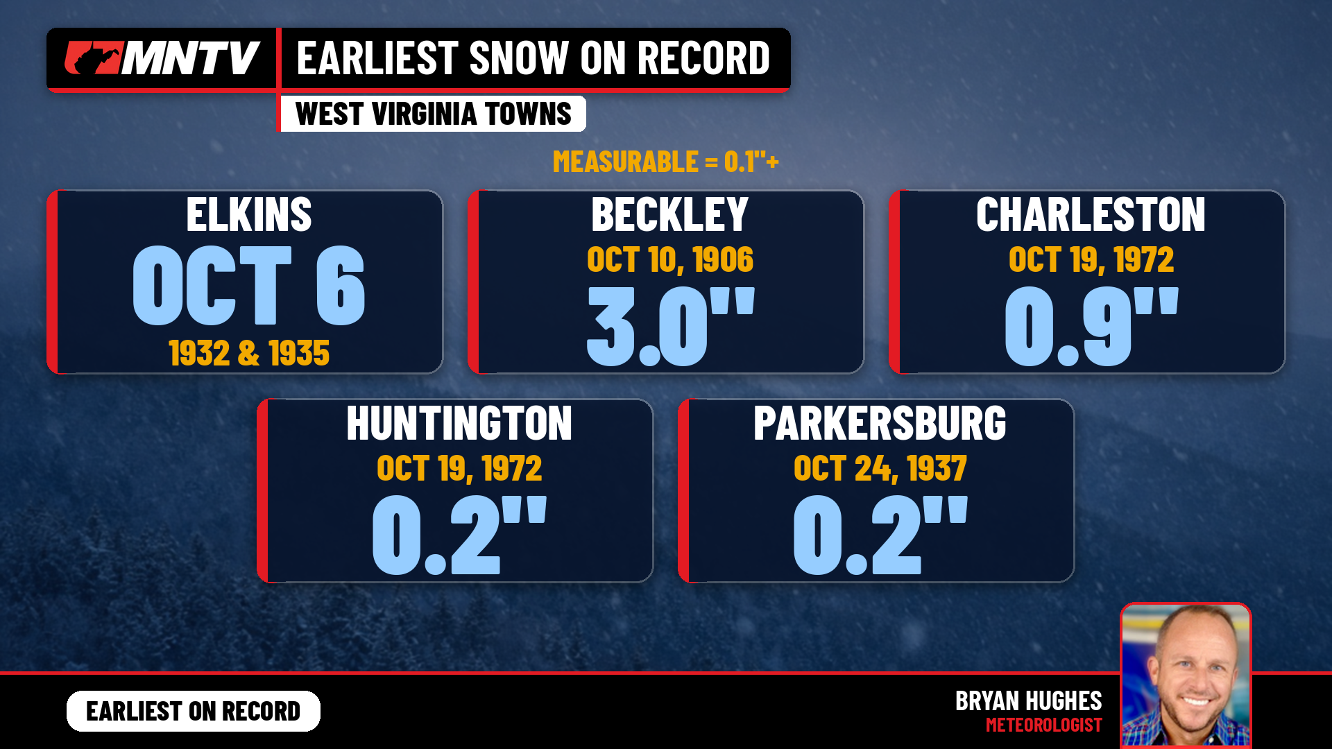 When does West Virginia usually see its first snow? Earlier than you might think
Every fall somebody asks the same question: when does the first snow usually show up in West Virginia? It’s a fair one. Leaves are still hanging on in a lot of places, football season is in full swing, and Halloween…
-
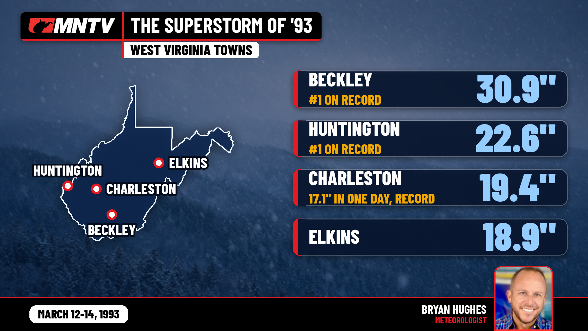 The Storm of the Century: When West Virginia Disappeared Under Feet of Snow
I’ve been forecasting West Virginia weather for 27 years, and there’s one storm folks still bring up at the grocery store, at ballgames, and in my Facebook comments: March 12-14, 1993. You might know it as the…
-
 New weather warnings as third storm set to hit Scotland
Two new weather warnings have been issued as a third storm in a matter of days is set to batter Scotland. It comes as thousands of homes across the country remain without power in the aftermath of Storm Boelo. A yellow…
-
 Woodbury BMX racer dominating the competition at 14
CBS News Minnesota is a local news organization that is part of CBS News and Stations. Also referred to as WCCO-TV and channel 4, CBS News Minnesota offers local breaking news, weather coverage and investigative…
-
 Why some Minnesotans will pay more for health insurance in 2027
The high cost of healthcare is hitting Minnesotans hard. The issue is top of mind for many voters just eight days before the midterm elections. Caroline Cummings has more on the double-digit increases some could face in…
-
 64% in U.S. say AI is developing too fast. An AI strategist says candidates aren’t addressing it.
Dan Mallin of the AI consultancy Magnetive says none of the candidates he has seen are taking a stand on AI governance. He says he supports embracing the technology but wants guardrails at every level, including…
-
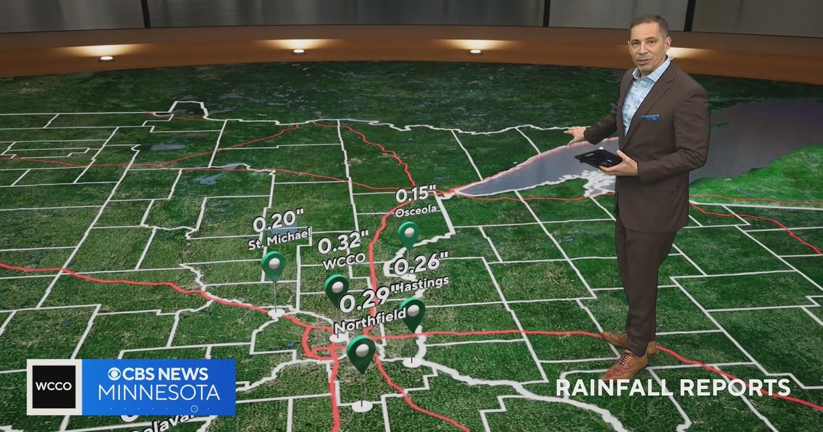 Minnesota weather on Halloween: a few light showers, but not a washout, and mild
CBS News Minnesota is a local news organization that is part of CBS News and Stations. Also referred to as WCCO-TV and channel 4, CBS News Minnesota offers local breaking news, weather coverage and investigative…
-
 WCCO digital headlines: Afternoon of Oct. 26, 2026
CBS News Minnesota is a local news organization that is part of CBS News and Stations. Also referred to as WCCO-TV and channel 4, CBS News Minnesota offers local breaking news, weather coverage and investigative…
-
 Farmers’ Almanac Predicts Thanksgiving Weather Forecast
Oct 26, 2026 at 12:16 PM EDT The Farmers’ Almanac has predicted that weather across the U.S. will be fairly typical of late November over Thanksgiving week, with a mix of cool and mild conditions, snow possible in some…
-
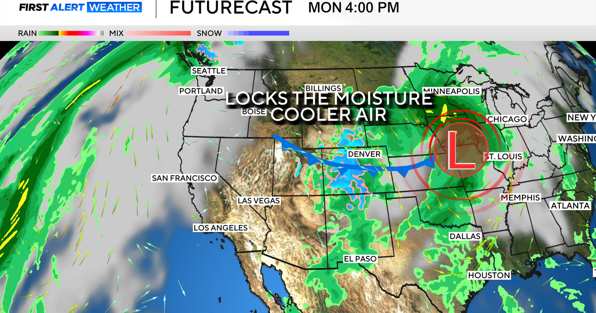 Colorado's dry week could end with a big storm bringing heavy rain and mountain snow
October 26, 2026 / 12:52 PM MDT / CBS Colorado Another storm is looming in Colorado's extended forecast, and we've seen this play out before. The script remains familiar: A surge of Pacific moisture moves into the…
Air quality
Air quality is satisfactory, and air pollution poses little or no risk.
Greenbrier County, WV reporting area · 1 hr ago. Data from AirNow (EPA and its state, local and tribal partners); preliminary and subject to change.
Sun & moon
Almanac
MonthlyWhite Sulphur Springs, records since 1895. Normals 1991–2020. Data from NOAA's Regional Climate Centers (ACIS).
Nearby
- Salem 60 km
- Hollins 59 km
- Covington 27 km
- Lewisburg 13 km
- Clifton Forge 42 km
- Cloverdale 59 km
- Daleville 55 km
- Hinton 54 km
- Fairlawn 28 km
Forecasters' discussion
From the National Weather Service office in RNK, issued 7 hrs ago
What Has Changed
Updated aviation forecasts.
No significant changes to the forecast. Guidance maintains dry forecast through the week in spite of some periodic cloud cover.
Key Messages
1) Dry and seasonable weather continues through the week. The first day of November could bring some rain.
Discussion
KEY MESSAGE 1: Dry and seasonable weather continues through the week. The first day of November could bring some rain.
High pressure remains more or less over the Mid-Atlantic and the Southeastern states through the end of the month. The ridge will flatten out some in response to short wave energy moving through the faster flow to our north. Mid and upper level moisture will increase by midweek, but the next chance of rain will not come until a southern stream disturbance opens up and lifts towards the Mid-Atlantic around Halloween night (Saturday). With limited moisture and unorganized forcing, we may only see some spotty showers begin to develop overnight into the day after Halloween (Sunday). Other than increasing clouds, we should have good trick-or-treat weather with mild temperatures. Locations that miss out on that rain will have to wait until mid week to get another shot.
We may see some patchy frost tonight into Tuesday morning, otherwise expect the normal valley fog. Temperatures will be a few degrees within normal values, with highs in the 60s and 70s areawide, and lows in the 40s and 50s (save for tonight).
Aviation
Fog in the mountain valleys is expected again Tuesday morning. A wave of cirroform clouds arrives tonight but will thin out towards morning. It still may be enough to interrupt the fog process, perhaps keeping a few spots from becoming dense, and in particular have kept KLWB around 1SM as opposed to their usual quarter mile.
Aside from the fog, VFR conditions are expected through the 24 hour valid TAF period. Winds remain light and variable becoming calm overnight into the morning hours.
EXTENDED AVIATION OUTLOOK...
VFR conditions will likely continue through the week. Another layer of high cloud is expected to cross the region Wednesday with cloud bases AOA 20kft. The next best chance of any precipitation/sub-VFR conditions may not be until Sunday Nov 1st, but at the moment it looks spotty. Still looking at daily early morning impacts from river fog through the week with temporary impacts to vsbys for mainly mountain valley terminals such as KLWB and KBCB.
Forecasts, observations and alerts in the United States come from the National Weather Service (NOAA); radar from NOAA's Multi-Radar Multi-Sensor system; satellite imagery from NASA's Global Imagery Browse Services (GIBS) and NOAA's GOES satellites; the map from the U.S. Geological Survey's National Map; air quality from AirNow (EPA and its partners); hurricane information from the National Hurricane Center; climate normals and records from NOAA's Regional Climate Centers (ACIS). Forecasts outside the United States and the UV index: MET Norway (CC BY 4.0); observations outside the U.S.: airport reports via NOAA's Aviation Weather Center. Place names: GeoNames (CC BY 4.0). Data are copied on a schedule and may lag the sources; for warnings that affect your safety, follow your local National Weather Service office and emergency officials. Weather news is drawn from the 4Search index and reflects what the press published. Terms of use. How to use Weather