Install
Parkersburg, WV Weather
Current conditions
Observed at Parkersburg, Mid-Ohio Valley Regional Airport · 24 min ago
Forecast
10-day-
Tonight
Widespread fog after 4am. Mostly clear, with a low around 41. Wind around 0 mph.
-
Monday
Widespread fog before 10am. Sunny, with a high near 74. West wind around 1 mph.
-
Monday Night
Areas of fog after 2am. Partly cloudy, with a low around 45. Wind around 0 mph.
National Weather Service forecast updated 5 hrs ago.
Hourly
Hourly forecast- Now46°
- 2 AM45°
- 3 AM45°
- 4 AM44°
- 5 AM43°
- 6 AM42°
- 7 AM42°
- 8 AM41°
- 9 AM44°
- 10 AM51°
- 11 AM58°
- 12 PM63°
- 1 PM68°
- 2 PM71°
- 3 PM72°
- 4 PM74°
- 5 PM73°
- 6 PM70°
- 7 PM65°
- 8 PM58°
- 9 PM55°
- 10 PM54°
- 11 PM52°
- Tue12 AM51°
10-day forecast
Details- TonightOct 25Mostly Clear then Widespread Fog41°
- TodayOct 26Widespread Fog then Sunny45°74°
- TueOct 27Areas Of Fog then Mostly Sunny49°72°
- WedOct 28Partly Sunny48°73°
- ThuOct 29Sunny48°75°
- FriOct 30Mostly Sunny51°75°
- SatOct 31Partly Sunny21%57°74°
- SunNov 1Chance Rain Showers50%71°
- MonNov 2Cloudy0.04 in56°70°
- TueNov 3Rain0.27 in56°68°
Days after the National Weather Service's seven are MET Norway's outlook, a computer model with no forecaster's review.
Radar
Full mapWeather news near Parkersburg
More weather news-
 Quiet week ahead for the Mid-Ohio Valley
It is going to be a very quiet week across the Mid-Ohio Valley. With an area of high pressure stretch across the region, it is going to keep the sunshine around. This area of high pressure is expected ... PARKERSBURG…
-
 Cool and quiet weather week ahead for the MOV
Highs hover in the 60s and 70s over the coming week. PARKERSBURG, W.Va. (WTAP) - We’ll continue to warm up over the coming week. We’ll reach a high of 66F Monday. Highs will hover in the upper-60s to low-70s each day of…
-
 Chilly fall air arrives Friday night, very dry week ahead
PARKERSBURG, W.Va. (WTAP) - More rain is possible Friday evening and into the early overnight hours as our temps begin to plunge from this afternoon’s cold front. Tonight’s low will dip to 45F. Clouds will part early…
-
 Breezy and soggy end to the week
WTAP PARKERSBURG, W.Va. (WTAP) - It is going to be a messy end to the week as a cold front pushes through the Mid-Ohio Valley. This is going to bring in rain and windy weather. On top of that, the temperature will be…
-
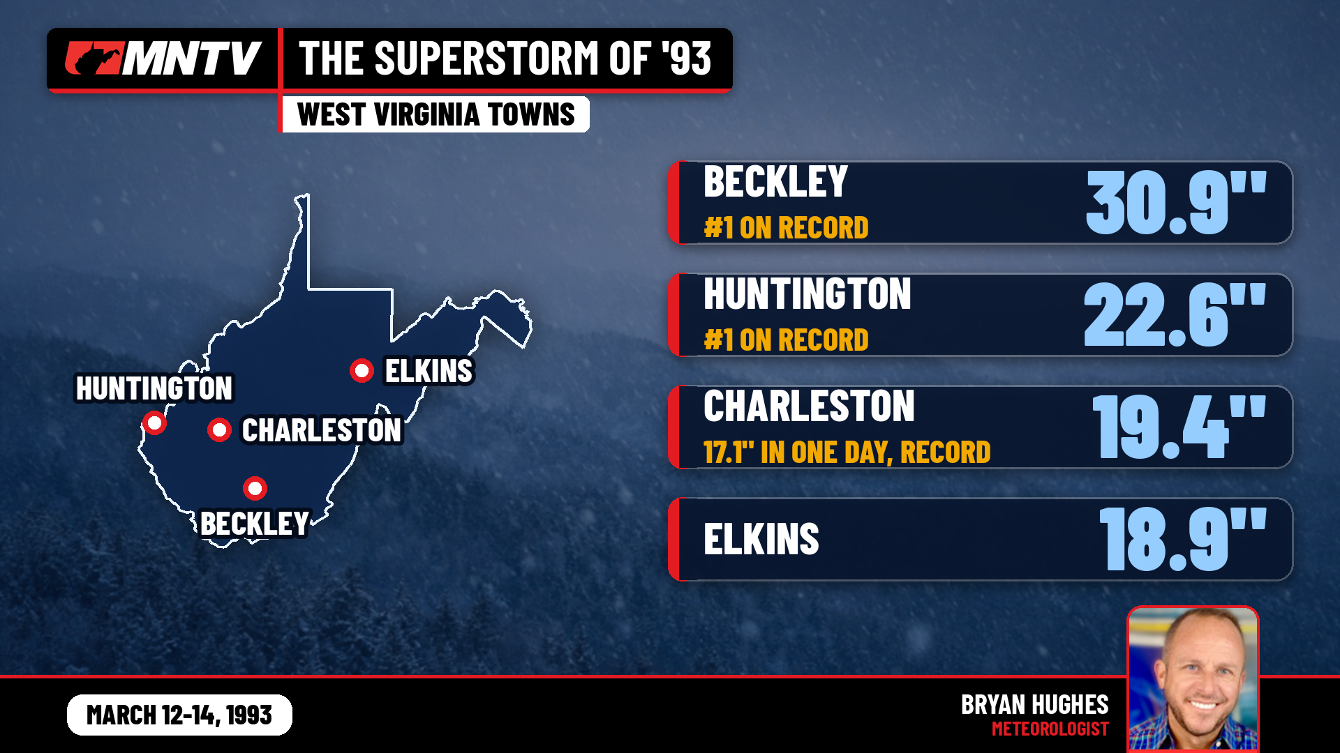 The Storm of the Century: When West Virginia Disappeared Under Feet of Snow
I’ve been forecasting West Virginia weather for 27 years, and there’s one storm folks still bring up at the grocery store, at ballgames, and in my Facebook comments: March 12-14, 1993. You might know it as the…
Air quality
Air quality is satisfactory, and air pollution poses little or no risk.
Parkersburg, WV reporting area · 1 hr ago. Data from AirNow (EPA and its state, local and tribal partners); preliminary and subject to change.
Sun & moon
Almanac
MonthlyParkersburg Area, records since 1926. Normals 1991–2020. Data from NOAA's Regional Climate Centers (ACIS).
Nearby
- Athens 47 km
- Marietta 19 km
- Vienna 7 km
- Belpre 1 km
- Ravenswood 39 km
- Ripley 51 km
- Blennerhassett 6 km
- The Plains 50 km
- Williamstown 18 km
- Devola 24 km
- Middleport 51 km
- Spencer 55 km
Forecasters' discussion
From the National Weather Service office in RLX, issued 7 hrs ago
What Has Changed
No significant changes have been made to the forecast for the upcoming work week.
Key Messages
1) Dry weather and morning riverine fog will continue into the upcoming work week, with rain chances holding off until late next weekend.
Discussion
KEY MESSAGE 1...
The 12Z objectively analyzed UA charts observed that the subtropical ridge, which is currently centered over the MS River Valley, has strengthened slightly compared to 24 hours ago, with geopotential heights now at 592 dam at 500 mb. The Omega Block is beginning to collapse due to a well-defined, positively-tilted shortwave trough that is ejecting over the Four Corners region. High temperatures for this afternoon and Monday were manually raised by a few degrees, as observations yesterday were slightly warmer than any of the NWP guidance; and this trend will hold as the subtropical ridge becomes centered over the Deep South by Monday evening. Otherwise, dewpoints were once again lowered to align closer to the drier MOS guidance; and pleasant fall weather will continue throughout the upcoming work week across the entire CWA. A weakening backdoor cold front will also sweep through the region during the day Tuesday and shift winds towards the northeast post-FROPA. The passage of this cold front will be rain-free; however, moistening of the boundary-layer will occur heading into Wednesday as the modified mP airmass trailing the cold front settles into the region. That said, high-level cirroform clouds will advect the region late Monday night, with the deck thickening heading into Wednesday as a remnant shortwave trough ejects over the Corn Belt. Overnight lows by the middle part of the week are forecast to be several degrees warmer compared to what has been observed recently, as the cirrus deck traps outgoing longwave radiation. Prospects for rain may return by late next weekend as the subtropical ridge deamplifies and restores cyclonic flow aloft.
Aviation
VFR conditions can be expected through the period with the exception of some late night early morning dense river valley fog.
FORECAST CONFIDENCE AND ALTERNATE SCENARIOS THROUGH 00Z TUESDAY...
FORECAST CONFIDENCE: High.
ALTERNATE SCENARIOS: Timing and location of fog could vary.
EXPERIMENTAL TABLE OF FLIGHT CATEGORY OBJECTIVELY SHOWS CONSISTENCY OF WFO FORECAST TO AVAILABLE MODEL INFORMATION: H = HIGH: TAF CONSISTENT WITH ALL MODELS OR ALL BUT ONE MODEL. M = MEDIUM: TAF HAS VARYING LEVEL OF CONSISTENCY WITH MODELS. L = LOW: TAF INCONSISTENT WITH ALL MODELS OR ALL BUT ONE MODEL.
UTC 1HRLY 19 20 21 22 23 00 01 02 03 04 05 06 EDT 1HRLY 15 16 17 18 19 20 21 22 23 00 01 02 CRW CONSISTENCY H H H H H H H H H H H H HTS CONSISTENCY H H H H H H H H H H H H BKW CONSISTENCY H H H H H H H H H H H H EKN CONSISTENCY H H H H H H H H H H H H PKB CONSISTENCY H H H H H H H H H H H M CKB CONSISTENCY H H H H H H H H H H H H
Forecasts, observations and alerts in the United States come from the National Weather Service (NOAA); radar from NOAA's Multi-Radar Multi-Sensor system; satellite imagery from NASA's Global Imagery Browse Services (GIBS) and NOAA's GOES satellites; the map from the U.S. Geological Survey's National Map; air quality from AirNow (EPA and its partners); hurricane information from the National Hurricane Center; climate normals and records from NOAA's Regional Climate Centers (ACIS). Forecasts outside the United States and the UV index: MET Norway (CC BY 4.0); observations outside the U.S.: airport reports via NOAA's Aviation Weather Center. Place names: GeoNames (CC BY 4.0). Data are copied on a schedule and may lag the sources; for warnings that affect your safety, follow your local National Weather Service office and emergency officials. Weather news is drawn from the 4Search index and reflects what the press published. Terms of use. How to use Weather