Install
Utica, NY Weather
Current conditions
Observed at Griffiss International Airport · 16 min ago
Forecast
10-day-
Overnight
Mostly clear, with a low around 37. Wind around 0 mph.
-
Tuesday
Sunny. High near 68, with temperatures falling to around 61 in the afternoon. Northwest wind 0 to 6 mph.
-
Tuesday Night
Mostly clear, with a low around 31. North wind 0 to 6 mph.
National Weather Service forecast updated 2 hrs ago.
Hourly
Hourly forecast- Now37°
- 6 AM37°
- 7 AM38°
- 8 AM40°
- 9 AM45°
- 10 AM49°
- 11 AM53°
- 12 PM57°
- 1 PM61°
- 2 PM64°
- 3 PM68°
- 4 PM62°
- 5 PM61°
- 6 PM56°
- 7 PM52°
- 8 PM50°
- 9 PM48°
- 10 PM45°
- 11 PM43°
- Wed12 AM41°
- 1 AM39°
- 2 AM37°
- 3 AM37°
- 4 AM36°
10-day forecast
Details- TonightOct 19Mostly Clear37°
- TodayOct 20Sunny31°68°
- WedOct 21Sunny34°62°
- ThuOct 22Sunny34°61°
- FriOct 23Sunny32°56°
- SatOct 24Sunny36°59°
- SunOct 25Sunny43°63°
- MonOct 26Mostly Sunny64°
- TueOct 27Rain0.11 in38°51°
- WedOct 28Cloudy38°43°
Days after the National Weather Service's seven are MET Norway's outlook, a computer model with no forecaster's review.
Radar
Full mapWeather news near Utica
More weather news-
 Saturday Evening Forecast
WKTV The coldest night yet tonight for the Mohawk Valley, Utica, and Rome is expected tonight where frost looks to be widespread A hard frost for the southern valleys and outlying areas Lows tonight in the upper 20s If…
-
 Skyecast: Oct. 15
WKTV UTICA, N.Y. (WKTV) -- Here's a look at the Walk the Dog Forecast. The Skyecast is brought to you by Nissan.
-
 Skyecast: Oct. 14
WKTV UTICA, N.Y. (WKTV) -- Here's a look at the Walk the Dog Forecast. The Skyecast is brought to you by Nissan.
-
 Skyecast: Oct. 13
Tonight's featured pup is Moosey from New Hartford. UTICA, N.Y. (WKTV) -- Here's a look at the Walk the Dog Forecast. The Skyecast is brought to you by Nissan.
-
 Freeze alerts stretch from Missouri to New York for Sunday
Temps drop for millions across the Central Plains, Midwest, Northeast The first real taste of fall is settling in for millions, including a few first frosts and freezes of the season for some in the Midwest and East…
-
 First Alert Weather: Bright sunshine, crisp air for Sunday in New York - 10/17/26
CBS News Detroit Weekend 11pm CBS News Los Angeles Weekend 8pm CBS News Philadelphia Weekend KDKA News Weekend 11pm CBS News Texas Weekend 10pm
-
 First Alert Weather: Clear skies with chilly temps Sunday in New York - 10/17/26
CBS News Bay Area Evening Edition Weekend 6pm CBS News Detroit Weekend 6pm CBS News Los Angeles Weekend 6pm CBS News Philadelphia 7:30pm Health Watch on CBS News Sacramento CBS News Texas Saturday 5pm
-
 Dangerous Freeze Warnings for 7 Counties in New York as Temperatures Plummet
Freeze Warnings take effect tonight across parts of New York, with lows in the upper 20s to around 30 expected from the Hudson Valley to Buffalo. The warnings run into 9 a.m. EDT Sunday. Frost and freeze conditions…
-
 First Alert Weather: Feels like November Saturday in New York - 10/17/26
CBS News Bay Area Morning Edition Weekend 6am WBZ This Morning 8am CBS News Chicago Saturday 8am CBS Colorado Mornings Weekend CBS News Los Angeles Weekend 6am CBS News Miami This Morning 9am WCCO News Saturday Morning…
-
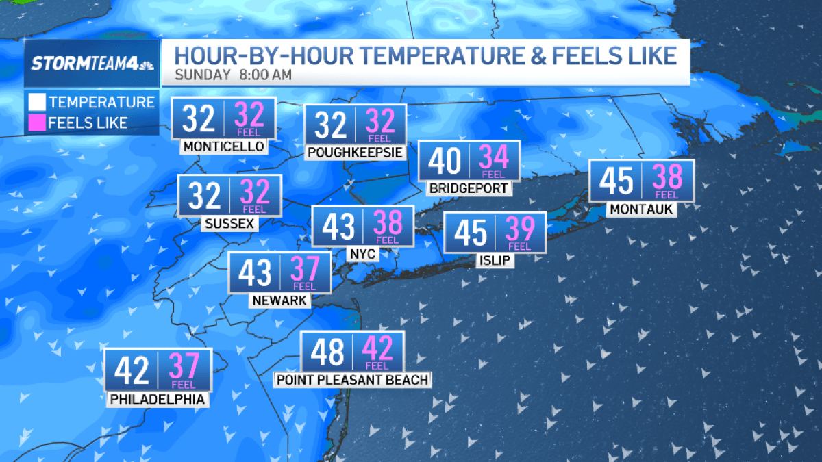 Bundle up! Cold snap hits New York City this weekend
The Friday night severe thunderstorm threat may have passed, but our weekend weather woes are not over quite yet. A surge of much colder air now sweeps across the region. Saturday is forecast to be windy and noticeably…
Sun & moon
Almanac
MonthlyTrenton Falls, records since 1928. Normals 1991–2020. Data from NOAA's Regional Climate Centers (ACIS).
Nearby
- Rome 22 km
- Oneida 34 km
- Ilion 19 km
- Herkimer 22 km
- Chittenango 52 km
- Little Falls 31 km
- Kirkville 58 km
- Canastota 42 km
- Hamilton 40 km
- Whitesboro 5 km
- New York Mills 5 km
- Sherrill 30 km
Forecasters' discussion
From the National Weather Service office in BGM, issued 3 hrs ago
What Has Changed
Minor adjustments were made to account for the large diurnal temperature swings each day.
Key Messages
1) High pressure will bring quiet weather conditions through this week and into the start of next week.
Discussion
KEY MESSAGE 1...
High pressure will remain in control through this week and into the start of next week. A weak cold front will move through today, which could keep temperatures a couple degrees cooler than yesterday. Winds will be breezy as the front moves through. A Nor'easter along the coast will inch closer to the coastline Wednesday night into Thursday. Precipitation from this system is not expected to extend much inland, though with a tightening pressure gradient, winds will become gusty. At the same time, a cold front approaches from the northwest. Most models have it running out of moisture by the time it enters the region, but the ECMWF has been consistent over the last several runs now with showing minimal amounts of precipitation for parts of the region. With 1000-500mb RH values at around 60% in the ECMWF, moisture is even limited with that solution. If anything can develop during this time, it will likely be very light. A slight cool down is expected at the end of the week following the frontal passage, though temperatures will rebound over the weekend.
As needed over the last few forecast updates, adjustments were made to temperatures and dewpoints. Sunny skies have led to temperatures climbing above what most guidance had. Meanwhile, these clear skies have then led to temperatures tanking at night while an inversion has kept the higher elevations more mild. During peak heating, dewpoints have been significantly lowered as model guidance have often been too high.
Aviation
VFR conditions under high pressure expected across all terminals for most of the TAF period. The only terminal that may see some restrictions tonight is KSYR. Winds have gone calm over the past several hours, dropping temperatures a little quicker than forecast. Low temps could fall into the mid 30s around sunrise and with crossover temperatures in the mid 30s, we could get some patchy fog to develop.
Outlook...
Tuesday afternoon through Saturday...Mainly VFR. Morning fog at KELM possible each morning.
Forecasts, observations and alerts in the United States come from the National Weather Service (NOAA); radar from NOAA's Multi-Radar Multi-Sensor system; satellite imagery from NASA's Global Imagery Browse Services (GIBS) and NOAA's GOES satellites; the map from the U.S. Geological Survey's National Map; air quality from AirNow (EPA and its partners); hurricane information from the National Hurricane Center; climate normals and records from NOAA's Regional Climate Centers (ACIS). Forecasts outside the United States and the UV index: MET Norway (CC BY 4.0); observations outside the U.S.: airport reports via NOAA's Aviation Weather Center. Place names: GeoNames (CC BY 4.0). Data are copied on a schedule and may lag the sources; for warnings that affect your safety, follow your local National Weather Service office and emergency officials. Weather news is drawn from the 4Search index and reflects what the press published. Terms of use.