Install
Eunice, NM Weather
Current conditions
Observed at Seminole, Gaines County Airport · 1 hr ago
Forecast
10-day-
Tuesday
Sunny, with a high near 78. Southeast wind 5 to 10 mph.
-
Tuesday Night
Partly cloudy, with a low around 55. Southeast wind 5 to 10 mph.
-
Wednesday
Mostly sunny, with a high near 81. Southeast wind 5 to 10 mph.
National Weather Service forecast updated 7 hrs ago.
Hourly
Hourly forecast- Now52°
- 9 AM58°
- 10 AM62°
- 11 AM67°
- 12 PM71°
- 1 PM74°
- 2 PM76°
- 3 PM78°
- 4 PM78°
- 5 PM77°
- 6 PM75°
- 7 PM70°
- 8 PM67°
- 9 PM65°
- 10 PM63°
- 11 PM62°
- Wed12 AM60°
- 1 AM59°
- 2 AM58°
- 3 AM57°
- 4 AM56°
- 5 AM56°
- 6 AM55°
- 7 AM55°
10-day forecast
Details- TonightOct 19Mostly Clear50°
- TodayOct 20Sunny55°78°
- WedOct 21Mostly Sunny55°81°
- ThuOct 22Mostly Sunny58°80°
- FriOct 23Partly Sunny58%57°78°
- SatOct 24Chance Showers And Thunderstorms57%57°74°
- SunOct 25Chance Showers And Thunderstorms52%56°68°
- MonOct 26Chance Rain Showers41%66°
- TueOct 27Heavy rain0.97 in54°61°
- WedOct 28Showers0.07 in54°64°
Days after the National Weather Service's seven are MET Norway's outlook, a computer model with no forecaster's review.
Radar
Full mapWeather news in New Mexico
More weather news-
 Rain and cooler temperatures around New Mexico
Isolated rain with very spotty lightning activity is once again present mostly in parts of western and southern New Mexico as clouds are present across the region. Skies are generally partly to mostly cloudy with some…
-
 Heavy rain and flash flooding possible in New Mexico, southwest Colorado this week
A strong storm system will bring widespread rain to New Mexico and southwest Colorado Wednesday through Friday. Heavy rainfall could lead to flash flooding, especially Thursday and Friday. Several inches of rain are…
-
 Warm days, chilly nights: New Mexico’s weekend weather outlook
ALBUQUERQUE, N.M. – After a cold morning, most of New Mexico will see sunshine and afternoon highs in the 60s. Saturday night will not be as cold, but some parts of the northern mountains and northeast New Mexico may…
-
 Freeze warning issued Friday night for much of New Mexico
ALBUQUERQUE, N.M. – A freeze warning covers much of New Mexico Friday night as temperatures fall into the 30s and 20s across most of the state. Southern New Mexico still has some gusty winds, but those winds will…
-
 High wind warning and freeze alert issued for New Mexico Thursday night
ALBUQUERQUE, N.M. – A strong cold front will bring a significant east wind event across New Mexico, with potentially damaging gusts and the coldest air of the season so far. The front is pushing south and west across…
-
 High winds trigger NMDOT travel advisory in southern New Mexico
New Mexico transportation officials are warning drivers in southern counties about high winds, blowing dust and difficult travel conditions through October 17. New Mexico transportation agencies have issued a high wind…
-
 High wind warnings and travel advisory for southern New Mexico
High winds up to 60 mph are forecast across southern New Mexico from Thursday evening, prompting highway travel advisories and warnings for blowing dust. Strong fall winds are expected to sweep across southern New…
-
 High winds and travel advisory issued for southern New Mexico
The New Mexico Department of Transportation is warning people to use caution when traveling in southern New Mexico. Strong winds and blowing dust are expected to impact travel from October 15-17, with conditions…
-
 Seasonable Thursday before chillier Friday in New Mexico
KOB 4 Seasonable Thursday before chillier Friday in New Mexico Meteorologist Amanda Goluszka’s Forecast: Oct. 15, 2026 ALBUQUERQUE, N.M. — Highs will be seasonably average for many in New Mexico, including the…
-
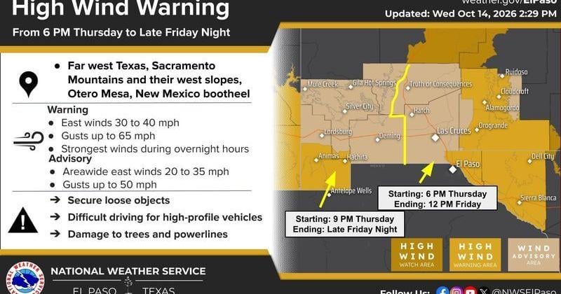 The National Weather Service in El Paso has issued a High Wind Warning and Wind Advisory for portions of far West Texas and southern New Mexico beginning Thursday evening, Oct. 15, and continuing into Friday, Oct. 16.
The Lufkin Daily News The National Weather Service in El Paso has issued a High Wind Warning and Wind Advisory for portions of far West Texas and southern New Mexico beginning Thursday evening, Oct. 15, and continuing…
Air quality
Air quality is satisfactory, and air pollution poses little or no risk.
Hobbs, NM reporting area · 1 hr ago. Data from AirNow (EPA and its state, local and tribal partners); preliminary and subject to change.
Sun & moon
Almanac
MonthlyHobbs Faa, records since 1941. Normals 1991–2020. Data from NOAA's Regional Climate Centers (ACIS).
Nearby
Forecasters' discussion
From the National Weather Service office in MAF, issued 3 hrs ago
Key Messages
Updated at 602 AM CDT Tue Oct 20 2026
- Temperatures trend back to slightly above normal this week.
- Low to medium (20-60%) rain chances return late Thursday through Saturday. The best chance of rain will be over our western counties.
Short Term
(Today through Wednesday afternoon) Issued at 225 AM CDT Tue Oct 20 2026
A disturbance that caused severe weather yesterday across S NM has weakened, but continues to spread clouds across the higher terrain. This has kept temperatures more mild and mostly in the 60s while areas to the east have fallen into the 50s. While a shower or two is possible across Eddy Co. with this passing disturbance, we don't expect any impacts.
Mid level ridging will quickly build over the region today helping to increase subsidence. This will push any convective activity even further west the next several days. Temperatures will continue to trend upward with highs back into the 80s into midweek with lows generally in the 50s.
Long Term
(Wednesday night through Monday) Issued at 225 AM CDT Tue Oct 20 2026
Ridging will dominate our weather through the week with temperatures continuing above normal. Rain chances remain at zero until late Thursday at the earliest when the ridge finally breaks down and southwesterly flow increases aloft. This will be the beginning of an extended period of rain chances as general troughing remains to our west into next week. Given this pattern, will need to monitor for a heavy rain threat, especially if we see any moisture from a very active Eastern Pacific hurricane season.
Aviation
(12Z TAFS) Issued at 602 AM CDT Tue Oct 20 2026
VFR continues through the period along with southerly winds.
Forecasts, observations and alerts in the United States come from the National Weather Service (NOAA); radar from NOAA's Multi-Radar Multi-Sensor system; satellite imagery from NASA's Global Imagery Browse Services (GIBS) and NOAA's GOES satellites; the map from the U.S. Geological Survey's National Map; air quality from AirNow (EPA and its partners); hurricane information from the National Hurricane Center; climate normals and records from NOAA's Regional Climate Centers (ACIS). Forecasts outside the United States and the UV index: MET Norway (CC BY 4.0); observations outside the U.S.: airport reports via NOAA's Aviation Weather Center. Place names: GeoNames (CC BY 4.0). Data are copied on a schedule and may lag the sources; for warnings that affect your safety, follow your local National Weather Service office and emergency officials. Weather news is drawn from the 4Search index and reflects what the press published. Terms of use.