Install
Fort Lee, NJ Weather
Current conditions
Observed at New York City, Central Park · 47 min ago
Forecast
10-day-
Saturday Night
Mostly clear, with a low around 42.
-
Sunday
Sunny, with a high near 65.
-
Sunday Night
Mostly clear, with a low around 47.
National Weather Service forecast updated 4 days ago.
Hourly
Hourly forecast- Now55°
- 8 PM53°
- 9 PM51°
- 10 PM50°
- 11 PM48°
- Sun12 AM47°
- 1 AM46°
- 2 AM45°
- 3 AM44°
- 4 AM43°
- 5 AM43°
- 6 AM43°
- 7 AM43°
- 8 AM44°
- 9 AM46°
- 10 AM50°
- 11 AM53°
- 12 PM56°
- 1 PM59°
- 2 PM61°
- 3 PM63°
- 4 PM64°
- 5 PM64°
- 6 PM63°
10-day forecast
Details- TueOct 20Sunny49°68°
- WedOct 21Mostly Sunny48°63°
- ThuOct 22Sunny46°67°
- FriOct 23Sunny43°59°
- TodayOct 24Sunny42°60°
- SunOct 25Sunny47°65°
- MonOct 26Sunny52°69°
- TueOct 27Mostly sunny42°62°
- WedOct 28Cloudy38°54°
- ThuOct 29Cloudy0.02 in49°63°
Days after the National Weather Service's seven are MET Norway's outlook, a computer model with no forecaster's review.
Radar
Full mapWeather news in New Jersey
More weather news-
 Sunshine Sticks Around New Jersey, but Cooler Days Arrive Before the Weekend
Home » New Jersey » Sunshine Sticks Around New Jersey, but Cooler Days Arrive Before the Weekend New Jersey, Weather Report NEW JERSEY — Sunshine dominates the forecast from Tuesday, October 20, through Saturday…
-
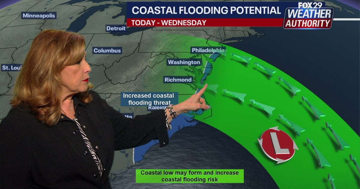 Coastal flooding threat looms for New Jersey, Delaware as nor'easter develops offshore
A developing nor'easter off the Carolina coast is expected to stay offshore but will still bring high winds, heavy surf, and possible coastal flooding along the Jersey Shore and Delaware beaches this week. PHILADELPHIA…
-
 New Jersey nor’easter threat grows as N.C. orders evacuations tonight
The freeze is only the first part of the forecast. Forecasters are also watching a slow moving nor’easter that could bring days of coastal flooding to the Jersey Shore next week. The warning covers Hunterdon, Morris…
-
 Bryan Norcross: Impactful nor'easter possible next week from North Carolina to New Jersey
A strong cold front is powering off the East Coast today. The coldest air of the year will blow in behind it. The front will push down the Florida Peninsula, but only slowly ease across South Florida, where heavy rain…
-
 El Niño: When the Pacific makes waves in New Jersey
You’ve probably heard that El Niño, a natural climate pattern that begins when warm ocean water develops in the tropical Pacific, is unfolding right now. El Niño is expected to strengthen through the fall and have its…
Air quality
Acceptable. Unusually sensitive people should consider limiting prolonged outdoor exertion.
Forecast
- SatGood (45)
- SunModerate (51)
- MonGood (47)
New York City Region, NY reporting area · 1 hr ago. Data from AirNow (EPA and its state, local and tribal partners); preliminary and subject to change.
Sun & moon
Almanac
MonthlyNew York-Central Park Area, records since 1869. Normals 1991–2020. Data from NOAA's Regional Climate Centers (ACIS).
Nearby
- New York City 15 km
- Brooklyn 22 km
- Queens 22 km
- Manhattan 8 km
- The Bronx 9 km
- Newark 21 km
- Jersey City 16 km
- Yonkers 11 km
- Paterson 18 km
- Elizabeth 29 km
- Greenburgh 23 km
- Clifton 16 km
Forecasters' discussion
From the National Weather Service office in OKX, issued 5 hrs ago
What Has Changed
Frost Advisory issued tonight for the CT coast and far eastern LI.
Key Messages
1) Frost Advisory in effect tonight for coastal CT and far eastern LI.
2) High pressure largely in control through the upcoming week.
Key Message 1
High pressure will remain over the area tonight with light winds and clear skies. Coastal CT and eastern portions of Suffolk County on LI will likely see another night of lows in the mid 30s and as low as 25 to 30 across the Pine Barrens region of LI. While the growing season has ended across the interior, it has yet to do so at the coast (Nov 1 or 11). Thus, a frost advisory in in effect for these areas once again. The only change this go around was to remove coastal Westchester.
Elsewhere, lows will range from the upper 20s across some of the interior, to as warm as the 40s across the NYC metro. These readings are about 3 to 5 degrees below normal for most locations.
Warm advection with building heights aloft should result in warmer temperatures Sunday night and less coverage of frost.
.KEY MESSAGE 2... An anomalously strong upper ridge from the Lower Mississippi Valley into the Great Lakes will translate east into Monday. A the same time, a strong upper low tracking across central and eastern Canada will suppress the upper ridge to the south, sending a cold front across the area Monday night. The frontal passage will be dry. Otherwise, the forecast area will be dominated by high pressure through the week.
Highs will be in the 60s Sunday and Monday, possibly getting to around 70 in the NYC/NJ metro on Monday. It will then cool down behind the cold front Monday night with highs mainly in the 50s for Tuesday and Wednesday. This will be a few degrees above normal. Frost coverage at the coast, where the growing season remains in effect, looks to be patchy at this time.
It warms up for the second half of the week with temperatures projecting to be well above normal by next Friday.
Outlook For 18z Sunday Through Thursday
Sunday-Thursday: VFR.
Detailed information, including hourly TAF wind component forecasts, can be found at: https:/www.weather.gov/zny/n90
Forecasts, observations and alerts in the United States come from the National Weather Service (NOAA); radar from NOAA's Multi-Radar Multi-Sensor system; satellite imagery from NASA's Global Imagery Browse Services (GIBS) and NOAA's GOES satellites; the map from the U.S. Geological Survey's National Map; air quality from AirNow (EPA and its partners); hurricane information from the National Hurricane Center; climate normals and records from NOAA's Regional Climate Centers (ACIS). Forecasts outside the United States and the UV index: MET Norway (CC BY 4.0); observations outside the U.S.: airport reports via NOAA's Aviation Weather Center. Place names: GeoNames (CC BY 4.0). Data are copied on a schedule and may lag the sources; for warnings that affect your safety, follow your local National Weather Service office and emergency officials. Weather news is drawn from the 4Search index and reflects what the press published. Terms of use.