Install
Morehead, KY Weather
Current conditions
Forecast for this hour (no station report in the last two hours)
Forecast
10-day-
Tonight
Areas of fog after midnight. Clear. Low around 37, with temperatures rising to around 38 overnight. East northeast wind 0 to 3 mph.
-
Saturday
Areas of fog before 7am, then areas of fog and patchy frost between 7am and 10am. Sunny, with a high near 72. Southeast wind around 1 mph.
-
Saturday Night
Areas of fog after midnight. Mostly clear. Low around 39, with temperatures rising to around 40 overnight. Wind around 0 mph.
National Weather Service forecast updated 10 hrs ago.
Hourly
Hourly forecast- Now45°
- Sat12 AM43°
- 1 AM42°
- 2 AM41°
- 3 AM41°
- 4 AM40°
- 5 AM38°
- 6 AM38°
- 7 AM37°
- 8 AM37°
- 9 AM40°
- 10 AM48°
- 11 AM57°
- 12 PM63°
- 1 PM67°
- 2 PM70°
- 3 PM72°
- 4 PM72°
- 5 PM72°
- 6 PM68°
- 7 PM63°
- 8 PM58°
- 9 PM53°
- 10 PM51°
10-day forecast
Details- TodayOct 23Sunny37°69°
- SatOct 24Areas Of Fog then Sunny39°72°
- SunOct 25Areas Of Fog then Sunny38°73°
- MonOct 26Sunny44°73°
- TueOct 27Mostly Sunny47°72°
- WedOct 28Partly Sunny47°73°
- ThuOct 29Sunny46°74°
- FriOct 30Mostly sunny45°63°
- SatOct 31Sunny40°60°
- SunNov 1Partly cloudy42°70°
Days after the National Weather Service's seven are MET Norway's outlook, a computer model with no forecaster's review.
Radar
Full mapWeather news near Morehead
More weather news- Strong Outer Banks nor’easter becomes Subtropical Storm Josephine
The nor’easter that’s flooded parts of North Carolina’s coast and choked the Outer Bank’s travel artery is now Subtropical Storm Josephine. While the storm is moving away from North Carolina and the East Coast…
-
 Early release from Hatteras Schools, conditions on NC 12 expected to worsen
Wednesday, October 21, 2026 October 21: Uncertainty about when NC12 will re-open on Hatteras/ Currituck Commissioners learn what SNAP changes will cost the county/ And a look at the amazing fall migration of birds…
-
 NWS sees increasing likelihood coastal storm will be ‘long duration event’
Wednesday, October 21, 2026 October 21: Uncertainty about when NC12 will re-open on Hatteras/ Currituck Commissioners learn what SNAP changes will cost the county/ And a look at the amazing fall migration of birds…
-
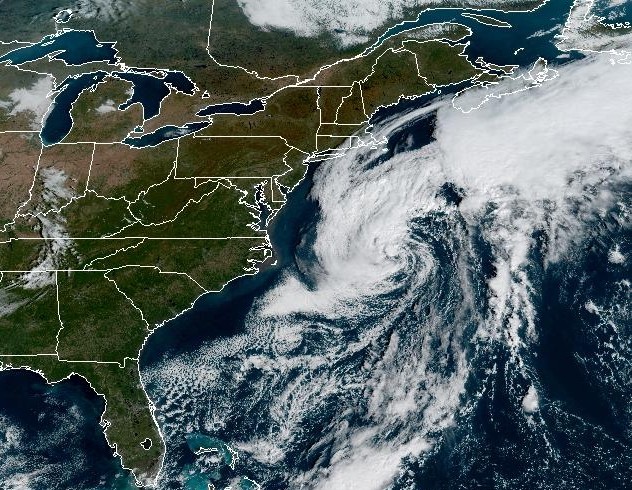 Nor’easter will stay offshore, but Connecticut faces gusty winds Wednesday
A nor'easter swirling off the East Coast will stay offshore as it moves north this week, bringing some strong winds to Connecticut. A nor'easter is hanging out off the East Coast of the U.S. this week, and while it's…
-
 Slow-moving nor'easter to spread gusty winds, coastal flooding to Northeast this week
A slow-moving storm traveling northward along the East Coast this week will pack strong winds and some rain around its core. As the center of the storm gradually migrates from off the coast of the Carolinas on Monday to…
- UPDATE: Mainland Dare under a wind advisory until Monday evening, says the NWS
The NWS Newport/Morehead City NC issued an updated wind advisory at 2:36 a.m. on Sunday in effect until Monday at 8 p.m. for Mainland Dare. "North winds 20 to 30 mph with gusts up to 45 mph," can be anticipated…
-
 Storm Warnings Issued Off the North and South Carolina Coast as Conditions Intensify
Storm Warnings are in effect for offshore waters from Oregon Inlet, North Carolina, to Little River Inlet, South Carolina, with north winds of 35 to 40 knots, gusts to 50 knots and seas up to 18 feet. A nor’easter is…
- UPDATE: High surf advisory in place for Ocracoke Island for Sunday and Monday
Charlotte Observer The creation of this content included the use of AI based on templates created, reviewed and edited by journalists in the newsroom. Read more on our AI policy here. The NWS Newport/Morehead City NC…
- UPDATE: High surf advisory issued for East Carteret for Sunday and Monday
Charlotte Observer The creation of this content included the use of AI based on templates created, reviewed and edited by journalists in the newsroom. Read more on our AI policy here. The NWS Newport/Morehead City NC…
- UPDATE: Wind advisory affecting Eastern North Carolina until Monday evening
An updated wind advisory was issued by the NWS Newport/Morehead City NC on Saturday at 2:14 p.m. in effect until Monday at 8 p.m. The advisory is for Northern Outer Banks, Ocracoke Island and Hatteras Island. The NWS…
Air quality
Acceptable. Unusually sensitive people should consider limiting prolonged outdoor exertion.
Ashland, KY reporting area · 1 hr ago. Data from AirNow (EPA and its state, local and tribal partners); preliminary and subject to change.
Sun & moon
Almanac
MonthlyCave Run Lake, records since 1904. Normals 1991–2020. Data from NOAA's Regional Climate Centers (ACIS).
Nearby
- Maysville 58 km
- Mount Sterling 47 km
- Grayson 45 km
- West Liberty 33 km
- Flemingsburg 37 km
- Stanton 53 km
- Carlisle 54 km
Forecasters' discussion
From the National Weather Service office in JKL, issued 4 hrs ago
Key Messages
- Dry weather persists into next week, with clear skies, mild days, and chilly nights expected.
- Light, patchy frost may develop late tonight and again on Saturday and Sunday nights in sheltered valleys away from lakes, rivers, and larger creeks. Fog is more likely near those bodies of water.
Update
Issued at 723 PM EDT FRI OCT 23 2026
With afternoon dew points dipping lower than was expected over the southwest portion of the forecast area, and models supporting continued somewhat drier low levels there overnight, have lowered tonight's forecast min temps there slightly.
Long Term
(Sunday through Friday) Issued at 157 PM EDT FRI OCT 23 2026
Amplified upper ridging over the Mississippi and Ohio River Valleys Sunday and Monday will gradually weaken and get shunted south and east of the area, opening eastern Kentucky to more westerly and/or west- southwesterly flow aloft mid to late next week. At the surface, high pressure will remain in control through much if not all of the period. A cold front may move into the Midwest and Great Lakes region by Wednesday and Thursday of next week, allowing for surface winds to increase out of the south to southwesterly, though wind speeds would remain light.
Sunny/clear skies and dry weather is expected through the period with mild days and cool, if not chilly, nights, with valley fog through the river valleys and patchy frost (at least for Sunday night and perhaps Monday night) in some sheltered valley locations removed from larger bodies of water. The one potential exception is around the middle of next week (i.e., Tuesday night through Wednesday) when most models depict a weakening shortwave crossing the area, bringing an increase in clouds. Such a scenario would likely bring warmer overnight lows and reduce ridge/valley splits in temperatures.
Aviation
(For the 00Z TAFS through 00Z Saturday evening) ISSUED AT 723 PM EDT FRI OCT 23 2026
Fog will bring IFR or worse conditions in some valley locations overnight and early Saturday, mainly near lakes, rivers, and large streams. KSYM has been affected by MVFR conditions around dawn in recent days, and with slightly higher low level moisture in our northern counties compared to recent days, have included some impacts there. Otherwise, VFR conditions with clear skies and light winds will prevail during the period.
Forecasts, observations and alerts in the United States come from the National Weather Service (NOAA); radar from NOAA's Multi-Radar Multi-Sensor system; satellite imagery from NASA's Global Imagery Browse Services (GIBS) and NOAA's GOES satellites; the map from the U.S. Geological Survey's National Map; air quality from AirNow (EPA and its partners); hurricane information from the National Hurricane Center; climate normals and records from NOAA's Regional Climate Centers (ACIS). Forecasts outside the United States and the UV index: MET Norway (CC BY 4.0); observations outside the U.S.: airport reports via NOAA's Aviation Weather Center. Place names: GeoNames (CC BY 4.0). Data are copied on a schedule and may lag the sources; for warnings that affect your safety, follow your local National Weather Service office and emergency officials. Weather news is drawn from the 4Search index and reflects what the press published. Terms of use.