Install
Holly Hill, FL Weather
Current conditions
Forecast for this hour (no station report in the last two hours)
Forecast
10-day-
Saturday
Rain showers likely before 2pm, then showers and thunderstorms. Mostly sunny, with a high near 77. Northeast wind 20 to 30 mph, with gusts as high as 40 mph. Chance of precipitation is 80%.
-
Saturday Night
Showers and thunderstorms. Partly cloudy, with a low around 69. Northeast wind around 30 mph, with gusts as high as 40 mph. Chance of precipitation is 80%.
-
Sunday
A chance of rain showers. Mostly sunny, with a high near 77. Northeast wind around 30 mph, with gusts as high as 40 mph. Chance of precipitation is 50%.
National Weather Service forecast updated 3 days ago.
Hourly
Hourly forecast- Now75°56%
- 2 PM75°80%
- 3 PM75°80%
- 4 PM75°80%
- 5 PM75°80%
- 6 PM74°80%
- 7 PM73°80%
- 8 PM72°36%
- 9 PM71°36%
- 10 PM71°36%
- 11 PM71°36%
- Sun12 AM71°36%
- 1 AM71°36%
- 2 AM71°15%
- 3 AM71°15%
- 4 AM70°15%
- 5 AM70°15%
- 6 AM70°15%
- 7 AM70°15%
- 8 AM70°29%
- 9 AM71°29%
- 10 AM73°29%
- 11 AM74°29%
- 12 PM75°29%
10-day forecast
Details- TonightOct 20Partly Cloudy67°
- WedOct 21Mostly Sunny then Slight Chance Rain Showers15%66°80°
- ThuOct 22Sunny66°77°
- FriOct 23Sunny27%68°77°
- TodayOct 24Showers And Thunderstorms80%69°77°
- SunOct 25Chance Rain Showers53%68°77°
- MonOct 26Chance Rain Showers43%67°77°
- TueOct 27Chance Rain Showers43%77°
- WedOct 28Cloudy69°76°
- ThuOct 29Mostly sunny64°76°
Days after the National Weather Service's seven are MET Norway's outlook, a computer model with no forecaster's review.
Radar
Full mapWeather news in Florida
More weather news-
 Low-pressure center brings strong winds and rain to central Florida
The wind today could gust to more than 30 mph across central Florida and up to 45 mph along the coast. These numbers will only increase on Sunday and Monday, when Orlando could have winds around 45 mph, and we could see…
-
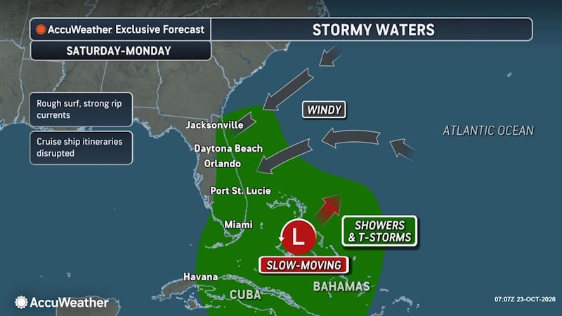 Rough Seas and Tropical Threats Loom Over Florida’s Atlantic Coast
Florida’s East Coast is already dealing with coastal flooding, gusty winds and dangerous surf, and a new area of potential tropical development could prolong or worsen those conditions early next week. Higher tides…
- Rain, strong winds and high surf ahead for Central Florida this weekend
ORLANDO, Fla. — Central Florida’s quiet weather will give way to increasing rain chances and gusty winds this weekend, with hazardous conditions developing along the coast. A trough of low pressure is expected to…
- A trough of low pressure will bring rain and wind to Central Florida
CENTRAL FLA. — After a quiet Friday, we are tracking Weather On the Way for the weekend. A trough of low pressure will develop over the Bahamas, increasing rain chances and wind over Central Florida. Tonight will be…
- Daily reference and potential evapotranspiration, and supporting meteorological data from weather stations, solar insolation data from the GOES satellite, and blue-sky albedo data from the MODIS satellite, Florida, 2023
Potential evapotranspiration (PET), and reference evapotranspiration (ETo) are estimated at an approximately 2-kilometer (approximately 0.019 degrees longitude and 0.018 degrees latitude) spatial grid and daily…
-
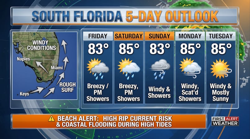 South Florida Forecast: Breezy Conditions, Persistent Beach Hazards, and Rising High Tides
Donna Thomas has studied hurricanes for two decades. She holds a PhD in history when her experience with Hurricane Andrew ultimately led her to earn a degree in broadcast meteorology from Mississippi State University…
-
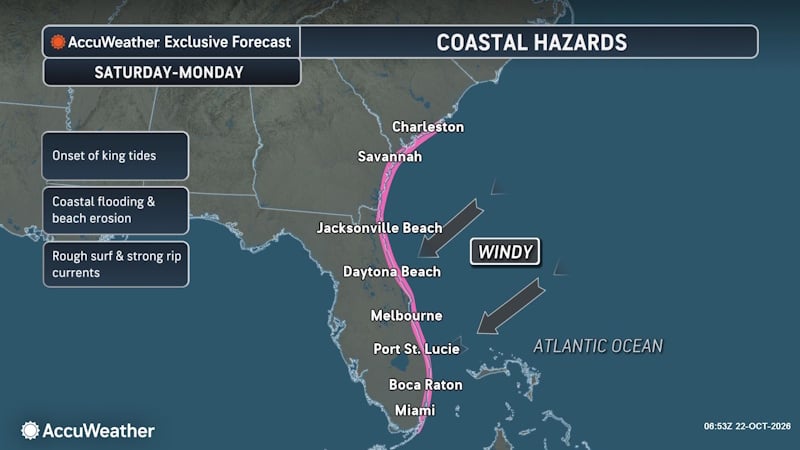 Rough Seas and Tropical Threat Loom Over Florida Coast, Risking Cruise Disruptions and Dangerous Surf
Persistent onshore winds could bring dangerous surf, rip currents and coastal disruptions from Jacksonville to Miami, with another tropical development threat looming this weekend into early next week. A slow-moving…
-
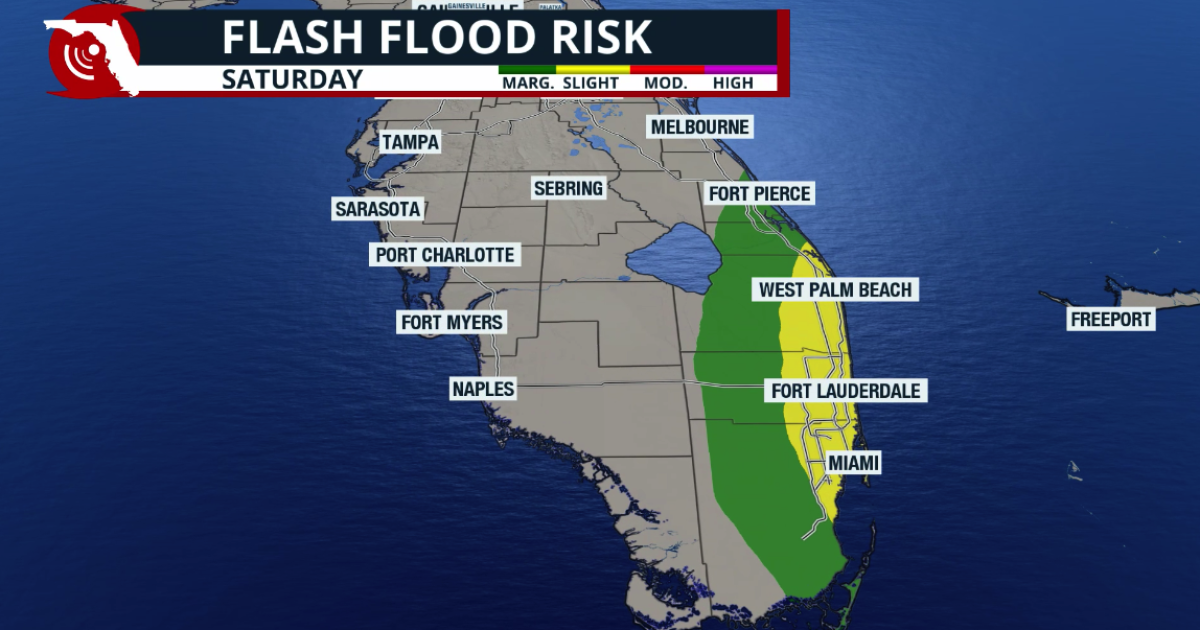 Josephine is born, moving away from the US; King Tides take over Florida
As Josephine moves away, South Florida will see a surge of tropical moisture from the south (unrelated to Josephine), increasing the chance of heavy rain that could cause flash floods. The rain could worsen coastal…
- Tropical trouble: Weather woes to plague Hawaii, Florida this week
If you're headed to Hawaii or Florida this week for spring break, be sure to pack the rain gear. Two of the USA's prime vacation spots are forecast to see a very wet, stormy week ahead, with flooding rains in both…
-
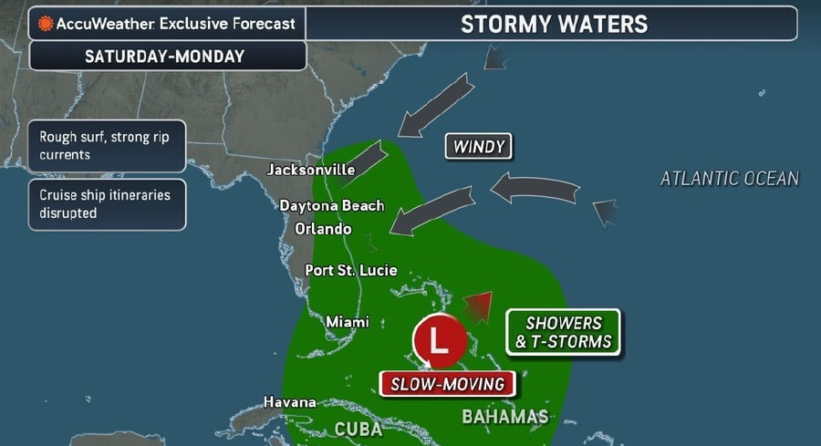 Rough Seas, Dangerous Rip Currents Threaten Florida Coast Ahead Of Possible Tropical Development
Persistent onshore winds and a slow-moving area of low pressure near the Bahamas are expected to bring hazardous surf, strong rip currents, and marine travel disruptions along Florida’s Atlantic coast starting this…
Air quality
Air quality is satisfactory, and air pollution poses little or no risk.
Forecast
- SatGood
- SunGood
- MonGood
Daytona Beach, FL reporting area · 1 hr ago. Data from AirNow (EPA and its state, local and tribal partners); preliminary and subject to change.
Sun & moon
Almanac
MonthlyDaytona Beach Area, records since 1923. Normals 1991–2020. Data from NOAA's Regional Climate Centers (ACIS).
Nearby
- Deltona 44 km
- Palm Coast 41 km
- Daytona Beach 4 km
- Port Orange 12 km
- Sanford 54 km
- Ormond Beach 5 km
- DeLand 35 km
- New Smyrna Beach 26 km
- Edgewater 31 km
- DeBary 48 km
- South Daytona 9 km
- Orange City 41 km
Forecasters' discussion
From the National Weather Service office in MLB, issued 6 hrs ago
Key Messages
Issued at 300 AM EDT Sat Oct 24 2026
- A prolonged period of hazardous to dangerous beach and boating conditions are forecast across east central Florida through this weekend and into next week. Entering the ocean is not advised!
- Rough, dangerous surf, minor to moderate coastal flooding, moderate to major beach erosion, a high risk of rip currents, and Gale conditions are forecast this weekend and early next week.
- Increasing rain and storm chances are forecast through the weekend. Minor flooding cannot be ruled out due to repeated rounds of showers and the potential for training bands of showers.
Discussion
Issued at 300 AM EDT Sat Oct 24 2026
Today-Tonight...The Florida peninsula remains wedged between a strengthening surface high pressure across the eastern US and a stalled boundary draped across the northern Caribbean, maintaining northeasterly winds locally. A tightening of the pressure gradient due to the strengthening high will lead to an increase in winds today, with sustained speeds forecast to reach 15 to 20 mph while gusts range between 25 to 35 mph. The strongest winds are anticipated along the coast, with conditions reaching Wind Advisory criteria along the Volusia and northern Brevard coastline starting at 2 PM and expanding southward along the coast at 2 AM. The persistent northeast winds are forecast to continue advecting moisture from the Atlantic towards the coast, with a southward- moving mid-level trough providing some energy aloft to support onshore-moving showers today. While isolated activity has already begun across the local waters, coverage is anticipated to increase this afternoon into the overnight hours, with the potential for some training bands to develop. As a result, WPC has outlooked the east coast in a Marginal Risk (1/4) of excessive rainfall today, with minor, localized flooding possible in some spots. Additionally, there is a low chance (20-30%) for storm activity to develop, with isolated lightning strikes and occasional stronger wind gusts possible. As mentioned, activity is anticipated to persist into the overnight hours, and farther intrusion inland of showers will be possible. Temperatures remain near normal, with highs in the upper 70s to low 80s and lows in the mid 60s to low 70s.
Hazardous to dangerous beach conditions are forecast along the east coast today as a result of the persistent northeast winds, high astronomical tides, and building seas. A high risk of rip currents is forecast along with rough surf. A High Surf Advisory has been issued for the Volusia and northern Brevard coasts starting at 11 AM, expanding southward to the rest of the east central Florida coast at 8 PM. Breaking waves of 6 to 10 feet are forecast, starting up north and expanding southward as seas continue to build overnight. The rough, pounding surf is also anticipated to result in beach erosion. A Coastal Flood Advisory is in effect along the entire east central Florida coastline for minor coastal flooding that is anticipated to peak during high tide, approximately between the hours of 5 to 7 AM/PM. Overall, conditions at the beach will be dangerous, and entering the ocean is not encouraged. Even heading to the beach could become hazardous, especially during periods of high tide.
Sunday-Tuesday...The surface high across the eastern US will continue to strengthen and push southward through this weekend and into early next week, while at the same time a broad area of low pressure gradually develops along a stalled boundary draped across the northern Caribbean and meanders across the western Atlantic. The result will be a continued tightening of the pressure gradient across the Florida peninsula, resulting in increasing wind speeds locally. Northeast winds are forecast to reach 20 to 25 mph with gusts up to 40 mph starting on Sunday, with these windy and gusty conditions persisting into Monday and Tuesday. Wind Advisories will likely be needed areawide beginning on Sunday, with high confidence for advisories across portions if not most of east central Florida through the start of the work week.
The persistent northeast flow will continue to advect moisture towards the Florida peninsula, with rain chances remaining high into Sunday (40-80%). Sunday looks to have the best chances for activity to push farther inland, and there is also a low chance (20-40%) for some storm development with activity as well. Any storms that do manage to develop may be capable of producing lightning strikes and strong wind gusts. Additionally, with the persistent northeast flow, training bands may develop across east central Florida, raising the risk for localized flooding. There is currently a Slight Risk (2/4) of excessive rainfall across portions of the Treasure Coast, with a Marginal Risk (1/4) along northern portions of the coast. By Monday and Tuesday, rain chances are anticipated to decrease slightly to 30- 50%, with the highest coverage forecast along the coast primarily from the Cape southward. Minor flooding will remain a concern, with a Marginal Risk (1/4) of excessive rainfall continuing across portions of the Treasure Coast into Monday and Tuesday. Temperatures are forecast to remain seasonable in the upper 70s to low 80s during the afternoon hours, falling into the 60s to low 70s during the overnight hours.
With the persistent northeast flow, continued high astronomical tides, and high wave heights forecast, dangerous surf conditions are anticipated to continue along the east coast through this weekend and into early next week. Entering the ocean is STRONGLY discouraged, and even heading to the beach could become dangerous, especially during high tides. A Coastal Flood Warning is now in effect beginning at 2 AM on Sunday for minor to moderate coastal flooding along the entire east central Florida coast. A high risk of rip currents will persist and the High Surf Advisory will continue along the entire east central Florida coast for breaking waves of 7 to 12 feet as well as moderate to major coastal erosion due to the pounding surf. Extensions in time of these coastal hazard products are highly likely given the anticipated prolonged nature of this event.
Marine
Issued at 300 AM EDT Sat Oct 24 2026
Hazardous to dangerous boating conditions are forecast across the local Atlantic waters through this weekend and into next week as a tightening pressure gradient across the local waters leads to increasing winds and seas. Northeast winds of 15 to 25 knots with gusts up to 30 knots today build to 20 to 30 knots with gusts up to 35 knots from Sunday onward. Seas of 6 to 9 feet today rapidly build tonight into Sunday up to 10 to 15 feet, highest across the Gulf Stream waters. Elevated seas are anticipated to linger through the middle of next week. A Small Craft Advisory across the local waters will upgrade into Gale Warnings, starting at 8 PM tonight across the Volusia and Brevard waters and at 8 AM Sunday across the Treasure Coast waters. For now, the Gale Warning continues through Monday, though extensions in time will be likely given the prolonged period of dangerous conditions.
Moisture increases across the local Atlantic waters through this weekend, with a return of scattered to numerous onshore-moving showers anticipated. Rain chances 40-70% today increase to 60-80% tonight through Monday, with a slight decrease in rain chances from Tuesday onward. There is a low chance (20-40%) for storm development with activity.
Aviation
(12Z TAFs) Issued at 607 AM EDT Sat Oct 24 2026
Generally VFR conditions continue through the TAF period outside of convection. N/NE flow near 10 kts across the interior and 10-15 kts with higher gusts along the coast early this morning. Winds will become NNE/NE through the day increasing to around 15 kts (G25 kts), except 15-20 kts (G25-30 kts) along the coast Cape northward. Winds remain elevated and gusty tonight (esp along the coast - actually increasing further MLB southward). Gradually increasing onshore-moving showers and ISOLD lightning storms thru the day and into tonight. Highest PoPs will be along the east coast diminishing into the interior. "Vicinity" wording in place with TEMPO groups later in the day/night. TEMPO MVFR invof convection.
Forecasts, observations and alerts in the United States come from the National Weather Service (NOAA); radar from NOAA's Multi-Radar Multi-Sensor system; satellite imagery from NASA's Global Imagery Browse Services (GIBS) and NOAA's GOES satellites; the map from the U.S. Geological Survey's National Map; air quality from AirNow (EPA and its partners); hurricane information from the National Hurricane Center; climate normals and records from NOAA's Regional Climate Centers (ACIS). Forecasts outside the United States and the UV index: MET Norway (CC BY 4.0); observations outside the U.S.: airport reports via NOAA's Aviation Weather Center. Place names: GeoNames (CC BY 4.0). Data are copied on a schedule and may lag the sources; for warnings that affect your safety, follow your local National Weather Service office and emergency officials. Weather news is drawn from the 4Search index and reflects what the press published. Terms of use.