Install
Underwood-Petersville, AL Weather
Current conditions
Observed at Lawrence County Airport · 1 hr ago
Forecast
10-day-
Monday Night
Mostly cloudy, with a low around 46.
-
Tuesday
Mostly sunny, with a high near 74.
-
Tuesday Night
Partly cloudy, with a low around 46.
National Weather Service forecast updated 4 days ago.
Hourly
Hourly forecast- Now63°
- 8 PM59°
- 9 PM55°
- 10 PM52°
- 11 PM50°
- Tue12 AM49°
- 1 AM49°
- 2 AM49°
- 3 AM48°
- 4 AM48°
- 5 AM47°
- 6 AM46°
- 7 AM47°
- 8 AM51°
- 9 AM57°
- 10 AM63°
- 11 AM67°
- 12 PM69°
- 1 PM71°
- 2 PM73°
- 3 PM74°
- 4 PM74°
- 5 PM72°
- 6 PM68°
10-day forecast
Details- TonightOct 22Clear46°
- FriOct 23Sunny44°75°
- SatOct 24Sunny44°74°
- SunOct 25Sunny47°73°
- TodayOct 26Mostly Sunny46°73°
- TueOct 27Mostly Sunny46°74°
- WedOct 28Mostly Sunny46°75°
- ThuOct 29Sunny76°
- FriOct 30Sunny48°67°
- SatOct 31Cloudy45°69°
Days after the National Weather Service's seven are MET Norway's outlook, a computer model with no forecaster's review.
Radar
Full mapWeather news in Alabama
More weather news-
 Sunny & pleasant today
For today, after a cool start, another pleasant afternoon. Sunny, temps in the low to mid 70s. Tonight, clear and cool. A full moon will light up the sky and be easy to see with clear conditions. Mid to upper 40s…
-
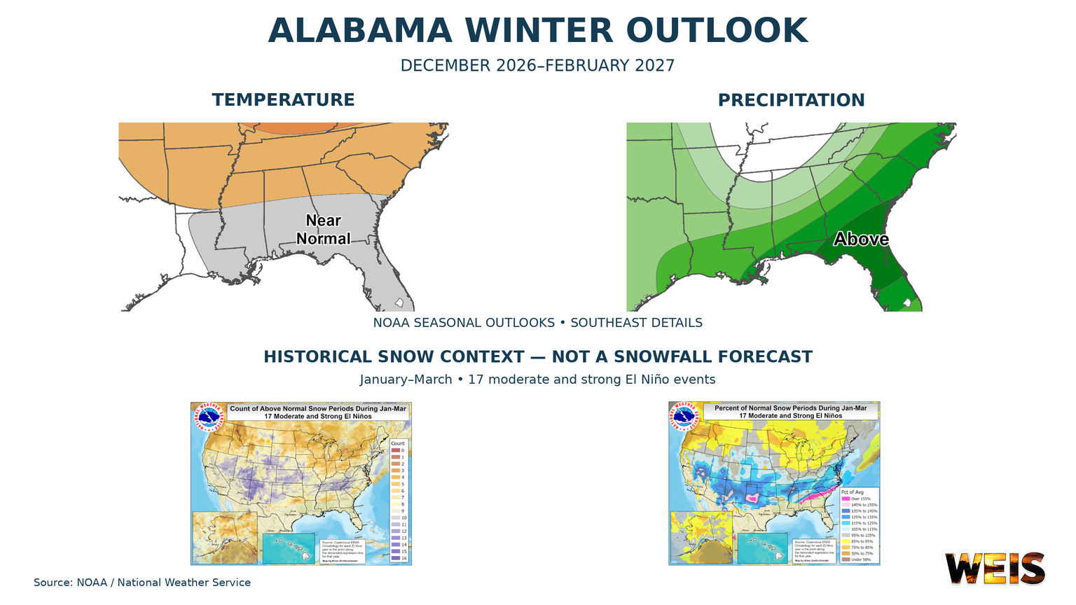 Alabama Winter Outlook Points to Wetter Conditions as El Niño Shapes the Season
CENTRE– Alabama’s winter outlook favors wetter conditions, with the strongest signal across southern Alabama and a weaker signal farther north. The outlook covers December 2026 through February 2027. NOAA released its…
-
 Nice and mild evening ahead
It’s another sunny and beautiful day in the Valley. This pattern will stick around for quite some time as the next chance for rain may be the start of November! HUNTSVILLE, Ala. (WAFF) - Happy Saturday! It’s another…
- Sunny & nice today and tomorrow
For today, sunny and nice. Temps in the low to mid 70s. Winds out of the east southeast 5-10 mph. Tonight, the nearly full moon will be easy to see with clear conditions. A cool night with lows in the 40s. Sunday, more…
-
 Cool night ahead for football, great fall weekend ahead
HUNTSVILLE, Ala. (WAFF) - Good afternoon and happy Friday! Today is a beautiful end to the work week with more sunshine and high temperatures nearing 80 degrees. It should be a great evening for high school football…
-
 First Alert: Fall-like conditions all weekend long
Temperatures start off chilly, but warm up comfortably into the mid 70s this afternoon. Lots of sunshine is expected this weekend with a small chance for a few passing clouds. Rinse and repeat tonight ... Temperatures…
-
 Vance intensifies rapidly and could become a major Category 3 hurricane
Vance had maximum sustained winds of 105 mph (170 kph) as it churned about 425 miles (685 kilometers) south-southwest of Acapulco, according to an advisory from the Miami-based hurricane center. It could become a major…
-
 First Alert: Fall-like weather continues for the weekend!
Tropical Update: An area of low pressure off of the mid-Atlantic coast of the United States become Subtropical Storm Josephine yesterday. The National Hurricane Center is still monitoring what could ... As the sun sets…
-
 Sunny, seasonal, and very dry stretch of days ahead
48 First Alert Weather Chief Meteorologist Brad Travis talks about a sunny, seasonal, and very dry stretch of days ahead. HUNTSVILLE, Ala. (WAFF) - Good Thursday afternoon. Today brings another pleasant warmup through…
-
 First Alert: Quiet, dry pattern continues through the weekend
Fall weather has stuck around lately, but will that continue over the next few days? Thursday night is quiet and calm, all ahead of a warm Friday! We wrap the workweek up with highs in the upper 70s, but could see a…
Air quality
Air quality is satisfactory, and air pollution poses little or no risk.
Loretto, TN reporting area · 1 hr ago. Data from AirNow (EPA and its state, local and tribal partners); preliminary and subject to change.
Sun & moon
Almanac
MonthlyMuscle Shoals Area, records since 1893. Normals 1991–2020. Data from NOAA's Regional Climate Centers (ACIS).
Nearby
- Florence 9 km
- East Florence 9 km
- Muscle Shoals 15 km
- Lawrenceburg 52 km
- Russellville 41 km
- Sheffield 12 km
- Tuscumbia 16 km
- Moulton 57 km
- Iuka 46 km
- Waynesboro 50 km
Forecasters' discussion
From the National Weather Service office in HUN, issued 1 hr ago
Key Messages
Updated at 851 AM CDT Mon Oct 26 2026
- Medium chances of showers and a few storms will return to the forecast Saturday into Sunday.
Near Term
(Tonight) Issued at 230 PM CDT Mon Oct 26 2026
There are currently some high clouds moving over our area, helping to keep temperatures from rising too much. It will be pleasant and a bit chilly tonight with low temperatures in the upper 40s to low 50s across our area, with light winds (<3 kts). This is partially due to a surface high that has been present today supported by an upper level ridge. The upper level ridge will move slowly eastward overnight. This will advect those higher clouds east overnight, and eventually out of our area by morning. These clouds aren't going to be too much of a hindrance on outgoing radiation, so expect lows to be near the upper 40s to low 50s across the area.
Short Term
(Tuesday through Wednesday) Issued at 851 AM CDT Mon Oct 26 2026
Over the next two days, the high will shift to the mid Atlantic and New England regions. A 5h ridge over the Gulf of America into the southeast U.S. will shift into the Carolinas and FL peninsula while weakening. This will allow a couple of shortwaves to enter the mid South and OH Valleys, but will only bring a few high clouds. Otherwise, temperatures will remain similar with highs in the middle 70s in the valleys) and upper 60s to lower 70s atop higher elevations of the Cumberland region.
Long Term
(Wednesday night through Sunday) Issued at 858 PM CDT Sun Oct 25 2026
Another ridge will attempt to build back into the Tennessee Valley late this week, resulting in sunny/dry weather Thursday and Friday and highs climbing to around 80 degrees each day. The ridge will begin to shift east on Saturday, with an area of low pressure developing over Texas and the lower Mississippi Valley Saturday night into Sunday. As it stands right now, Saturday (Halloween) looks to be a warm/dry day with increasing cloud cover -- with potentially some low rain chances returning to the forecast Saturday evening. Medium chances of showers will return to the forecast late Saturday night into Sunday as the low quickly shifts eastward across the Deep South. This will give the Tennessee Valley, it's best shot at appreciable rainfall in a couple weeks. We will need to resolve the timing of the system better, but our greatest confidence appears to be on Sunday for now.
Forecasts, observations and alerts in the United States come from the National Weather Service (NOAA); radar from NOAA's Multi-Radar Multi-Sensor system; satellite imagery from NASA's Global Imagery Browse Services (GIBS) and NOAA's GOES satellites; the map from the U.S. Geological Survey's National Map; air quality from AirNow (EPA and its partners); hurricane information from the National Hurricane Center; climate normals and records from NOAA's Regional Climate Centers (ACIS). Forecasts outside the United States and the UV index: MET Norway (CC BY 4.0); observations outside the U.S.: airport reports via NOAA's Aviation Weather Center. Place names: GeoNames (CC BY 4.0). Data are copied on a schedule and may lag the sources; for warnings that affect your safety, follow your local National Weather Service office and emergency officials. Weather news is drawn from the 4Search index and reflects what the press published. Terms of use. How to use Weather