Install
Camp Verde, AZ 86322 Weather
Current conditions
Forecast for this hour (no station report in the last two hours)
Forecast
10-day-
Today
Showers and thunderstorms. Some of the storms could be severe. Cloudy. High near 76, with temperatures falling to around 72 in the afternoon. Southeast wind 3 to 9 mph, with gusts as high as 21 mph. Chance of precipitation is 90%.
-
Tonight
Showers and thunderstorms. Cloudy, with a low around 58. Southeast wind around 5 mph. Chance of precipitation is 100%.
-
Thursday
Showers and thunderstorms. Cloudy. High near 71, with temperatures falling to around 66 in the afternoon. South wind 3 to 13 mph, with gusts as high as 26 mph. Chance of precipitation is 100%.
National Weather Service forecast updated 2 hrs ago.
Hourly
Hourly forecast- Now75°91%
- 2 PM76°91%
- 3 PM76°91%
- 4 PM75°91%
- 5 PM72°87%
- 6 PM70°87%
- 7 PM69°87%
- 8 PM67°87%
- 9 PM66°87%
- 10 PM66°87%
- 11 PM64°91%
- Thu12 AM64°91%
- 1 AM61°91%
- 2 AM61°91%
- 3 AM60°91%
- 4 AM60°91%
- 5 AM58°95%
- 6 AM58°95%
- 7 AM58°95%
- 8 AM59°95%
- 9 AM62°95%
- 10 AM67°95%
- 11 AM68°92%
- 12 PM71°92%
Daily forecast
Details- TodayOct 21Showers And Thunderstorms95%58°76°
- ThuOct 22Showers And Thunderstorms95%53°71°
- FriOct 23Patchy Fog then Mostly Sunny11%47°69°
- SatOct 24Patchy Fog then Sunny44°68°
- SunOct 25Sunny46°70°
- MonOct 26Sunny46°73°
- TueOct 27Sunny47°74°
- WedOct 28Partly cloudy50°73°
- ThuOct 29Partly cloudy49°73°
Days after the National Weather Service's seven are MET Norway's outlook, a computer model with no forecaster's review.
Radar
Full mapWeather news in Arizona
More weather news-
 History shows October storms can hit Arizona hard
KOLN | Nebraska Local News, Weather, Sports | Lincoln, NE History shows October storms can hit Arizona hard Vice President J.D. Vance has not yet arrived in North Platte, but his planned visit is already filling area…
-
 MOST ACCURATE FORECAST: Flood Watches across Arizona, strong to severe storms possible
PHOENIX — A powerful fall storm is moving into Arizona. It already gave us a preview. A severe storm dropped large hail from Chandler to Mesa Tuesday night. Winds will pick up, temperatures will drop and strong to…
- Severe weather chances increase in Arizona, with hail, tornado risks
Forecasts for the storms coming to Arizona have taken a more severe turn ahead of their arrival on Wednesday, Oct. 21. Recent updates from the Storm Prediction Center increased the threat level in the state up to an…
-
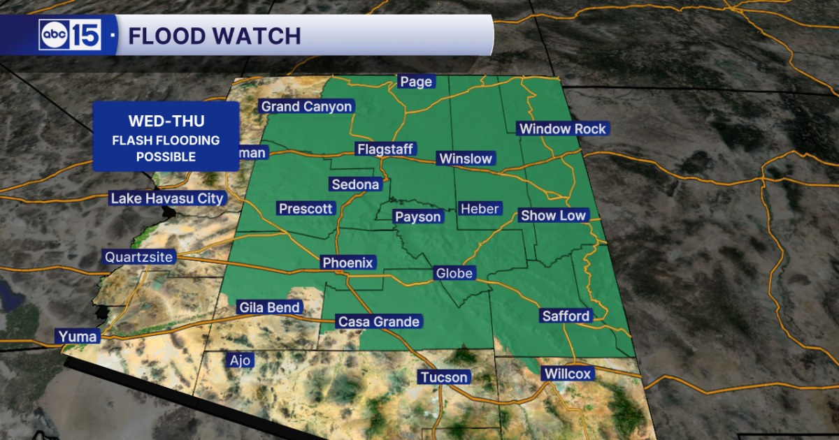 WHAT TO EXPECT: Heavy rain and flash flooding possible across Arizona midweek
Get ready for big weather changes across the state this week! A strong storm system off the California coast is pulling well-above-normal moisture into Arizona. The setup will fuel showers and thunderstorms across the…
- Flash-flood risk rises in Southern California, severe storms threaten Arizona
Satellite image of southwest U.S. at 17:20 UTC on October 20, 2026. Credit: NOAA/GOES-19, Zoom Earth, The Watchers The WPC Excessive Rainfall Discussion issued at 15:33 UTC on October 20 places portions of Southern…
-
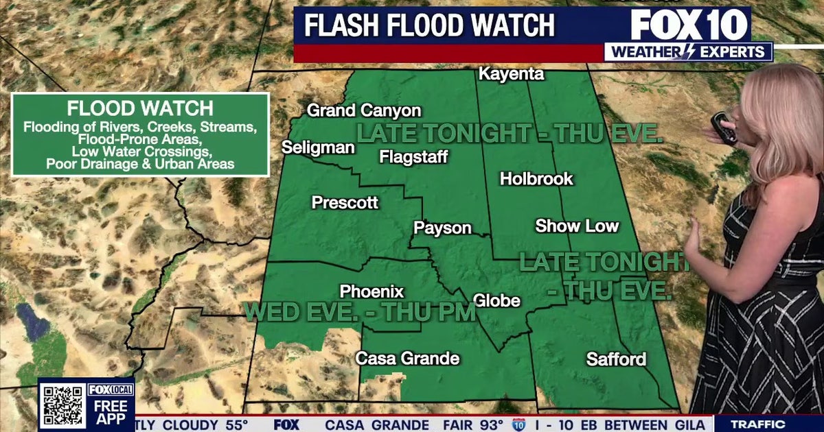 Arizona weather forecast: Heavy rain and severe storms approaching
The National Weather Service has issued flood watches across Arizona as heavy rain and severe storms are set to move into the region. PHOENIX - Plenty of change is expected over the next several days. What to Expect…
-
 Strong storm system headed to Arizona — here's when it'll hit
AZ Family Strong storm system headed to Arizona — here's when it'll hit How much rain could Phoenix get? Here’s the latest forecast Heavy rain, strong storms across Phoenix area expected later this week Sunny, warm…
-
 MOST ACCURATE FORECAST: Flood Watch issued as storm system heads to Arizona
PHOENIX — It’s a warm start to the week in the Valley! Phoenix topped out in the low 90s on Monday and we’ll do it again on Tuesday. We are tracking another storm system on the way that will drop temperatures for the…
-
 Fall system to bring heavy rain, strong storms to Arizona
PHOENIX (AZFamily) — A big weather change is ahead with a strong fall storm system headed toward the Desert Southwest. Wednesday and Thursday are First Alert Weather Days as several rounds of showers and thunderstorms…
-
 Timing rain chances across Arizona this week
AZ Family Timing rain chances across Arizona this week Heavy rain, strong storms across Phoenix area expected later this week Sunny, warm conditions in Arizona followed by rain this week Rain in forecast over the next…
Air quality
Air quality is satisfactory, and air pollution poses little or no risk.
Forecast
- WedGood (30)
- ThuGood (36)
- FriGood (39)
Prescott, AZ reporting area · 1 hr ago. Data from AirNow (EPA and its state, local and tribal partners); preliminary and subject to change.
Sun & moon
Almanac
MonthlyJerome, records since 1897. Normals 1991–2020. Data from NOAA's Regional Climate Centers (ACIS).
Nearby
- Prescott Valley 42 km
- Prescott 56 km
- Cottonwood 24 km
- Verde Village 21 km
- West Sedona 33 km
- Chino Valley 59 km
- Sedona 34 km
- Big Park 25 km
- Village of Oak Creek (Big Park) 25 km
- Lake Montezuma 10 km
- Clarkdale 29 km
- Dewey-Humboldt 36 km
Forecasters' discussion
From the National Weather Service office in FGZ, issued 8 hrs ago
Synopsis
A very active period of weather is anticipated over the next two days. A strong weather system is bringing widespread showers and thunderstorms this morning, and will continuing through Thursday. The primary concerns are flooding and flash flooding, severe thunderstorms, and even a few tornadoes. Drier conditions with lingering slight chances for showers are expected by Friday into the weekend.
Discussion
A concerning situation will evolve across Arizona over the next two days, with threats of flooding/flash flooding, severe thunderstorms, and tornadoes. A strong low pressure system off the California coast is beginning to move inland. This is well positioned to carry a deep moisture surge of tropical and subtropical origins, as well as provide an ideal environment for severe weather. The low eventually lifts through the Great Basin on Thursday, dragging a cold front through the region late Thursday into Friday.
This morning...The first surge of tropical moisture has arrived, and activity is ramping up quickly early this morning. Current mesoanalysis shows a 50-55kt jet overhead at 500mb, as well as a strengthening southeasterly low-level jet advecting warm air and high dewpoints into northern AZ. This has allowed for increasing instability south of the Rim during the overnight hours, with MLCAPE values currently around 250-500 J/kg in Yavapai and Gila counties. Coupled with bulk shear around 50kts and storm relative helicity 100- 200 m2/s2, we are seeing scattered discrete supercell thunderstorms initiating along the terrain as of 2 AM MST. This is expected to decline in extent over the next few hours as conditions become slightly more unfavorable, however continued thunderstorms activity is expected especially further west. Severe thunderstorms bringing 1- 2 inch hail have remained the primary threat thus far. A secondary threat of flash flooding is also in play this morning given the arrival of deep moisture. However fast storm motion and scattered coverage will allow rain accumulations to likely remain below flash flooding concerns outside of sensitive burn scars.
Today through Thursday evening...Threats of flash flooding and severe thunderstorms continue through the period. For flooding, we will remain in a continuous fetch of deep tropical/subtropical moisture with modest instability and enhanced low-level flow. Precipitable Water (a measure of atmospheric moisture) will rise to 0.8-1.2 inches across most of our area. This is highly anomalous for mid-October. Despite the fast expected storm motion, periods of training or back-building storms are possible and could lead to locally heavy rainfall rates with flash flooding concerns. Also several rounds of heavy rain are expected for most, and longer duration flooding of rivers, streams, normally dry washes, drainage basins, etc is possible. This is exacerbated further by very saturated surface conditions for all of northern AZ. As a result, a Flood Watch will be in effect beginning at 5 AM MST today and continuing through 11 PM MST Thursday. The threat of flooding ends on Thursday evening as a cold front sweeps from west to east and brings much drier air in its wake.
For the severe threat, an unstable environment with an impressive shear profile will be maintained through the period. The jet at 500mb will continue to strengthen on Wednesday as the low pressure system slowly approaches. Despite cloud cover to limit destabilization, hi-res guidance remains adamant that CAPE values up to 1000-1500 J/kg will develop by Wednesday afternoon with help from low-level moisture advection and steepening mid-level lapse rates. Several rounds of severe weather are possible, with the peak threat window beginning late Wednesday afternoon through evening. Stronger supercell storms will be capable of large 2+ inch hail, damaging wind gusts, and even a few tornadoes. SPC maintains an Enhanced risk (level 3 out of 5) of severe weather centered along the Mogollon Rim on Wednesday. Into Thursday, the severe threat looks to shift a bit further east towards the Eastern Mogollon Rim and White Mountains with potential for strong storms along the propagating cold front.
Be prepared and have a way to receive warnings!
Friday and onward...Activity is expected to trend downward by Friday into the weekend after the main trough axis pushes past Northern AZ and drier air moves in. A closed low may linger across western AZ, and slight chances for showers and thunderstorms remain in the forecast each day. Expect lighter winds and temperatures remaining below normal otherwise.
Aviation
Wednesday 21/12Z through Thursday 22/12Z...Scattered to numerous showers and thunderstorms this morning, becoming widespread by the mid-to-late afternoon. Drops to MVFR/IFR, especially near heavier showers or thunderstorms. Occasional severe storms with large hail or damaging wind are expected. Gusty and erratic winds near thunderstorms, else winds are SE-S 10-20kts gusting to 30 kts after 18Z Wednesday.
OUTLOOK...Thursday 22/12Z through Saturday 24/12Z...Periods of widespread showers and thunderstorms continue Thursday, then activity diminishes from west to east late Thursday night. Some severe storms with large hail or damaging winds expected. Drops to MVFR/IFR, especially near heavier showers or thunderstorms. Much drier by Friday, with slight chances for lingering showers. Winds S-SW 10-20 kts with gusts to 30 kts Thursday, SW-W 10-20kts Friday. Gusty and erratic winds near storms.
Fire Weather
This morning through Thursday...Increasing showers and thunderstorms this morning becoming widespread on Wednesday and Thursday. Some storms may produce very heavy rainfall leading to flooding or flash flooding both days. Some stronger storms may produce strong winds and large hail. Outside of storms, expect south winds 10-20 mph with gusts 30-40 mph on Wednesday, becoming south through southwest on Thursday. Daytime temperatures near to below normal.
Friday through Sunday...Isolated showers and thunderstorms are expected for Friday through Sunday. Southwest through west winds 10- 15 mph with gusts to 25 mph on Friday, then light northerly winds 5- 15 mph on Saturday and Sunday.
Forecasts, observations and alerts in the United States come from the National Weather Service (NOAA); radar from NOAA's Multi-Radar Multi-Sensor system; satellite imagery from NASA's Global Imagery Browse Services (GIBS) and NOAA's GOES satellites; the map from the U.S. Geological Survey's National Map; air quality from AirNow (EPA and its partners); hurricane information from the National Hurricane Center; climate normals and records from NOAA's Regional Climate Centers (ACIS). Forecasts outside the United States and the UV index: MET Norway (CC BY 4.0); observations outside the U.S.: airport reports via NOAA's Aviation Weather Center. Place names: GeoNames (CC BY 4.0). Data are copied on a schedule and may lag the sources; for warnings that affect your safety, follow your local National Weather Service office and emergency officials. Weather news is drawn from the 4Search index and reflects what the press published. Terms of use.