Install
Topeka, KS 66621 Weather
Current conditions
Observed at Topeka, Philip Billard Municipal Airport · 1 hr ago
Forecast
10-day-
Today
A chance of rain showers after 10am. Partly sunny, with a high near 71. South wind 5 to 10 mph.
-
Tonight
A chance of rain showers. Partly cloudy, with a low around 51. Southeast wind 0 to 5 mph. Chance of precipitation is 20%.
-
Wednesday
A chance of rain showers before 10am. Mostly sunny, with a high near 75. South wind 0 to 5 mph.
National Weather Service forecast updated 13 hrs ago.
Hourly
Hourly forecast- Now68°11%
- 3 PM69°11%
- 4 PM71°12%
- 5 PM69°11%
- 6 PM68°11%
- 7 PM65°10%
- 8 PM61°10%
- 9 PM59°
- 10 PM57°
- 11 PM56°10%
- Wed12 AM55°12%
- 1 AM55°13%
- 2 AM54°16%
- 3 AM54°19%
- 4 AM53°22%
- 5 AM52°19%
- 6 AM52°14%
- 7 AM52°11%
- 8 AM51°11%
- 9 AM53°11%
- 10 AM59°
- 11 AM64°
- 12 PM68°
- 1 PM72°
10-day forecast
Details- TodayOct 20Chance Rain Showers22%51°71°
- WedOct 21Chance Rain Showers then Mostly Sunny14%52°75°
- ThuOct 22Sunny54°77°
- FriOct 23Mostly Sunny57°77°
- SatOct 24Mostly Sunny13%56°77°
- SunOct 25Partly Sunny13%54°74°
- MonOct 26Slight Chance Rain Showers22%50°70°
- TueOct 27Light rain0.04 in50°57°
- WedOct 28Light rain0.02 in49°56°
- ThuOct 29Sunny46°60°
Days after the National Weather Service's seven are MET Norway's outlook, a computer model with no forecaster's review.
Radar
Full mapWeather news near Topeka
More weather news-
 Tuesday forecast: Mild, low rain chance
WIBW TOPEKA, Kan. (WIBW) - Highs today will be a few degrees warmer than yesterday despite the cloud cover and a low rain chance. The chance of rain today (into tonight) is low but don’t be surprised by a passing light…
-
 Monday forecast: Seasonal again today
TOPEKA, Kan. (WIBW) - Seasonal temperatures will continue, similar if not a few degrees warmer than yesterday with a more noticeable warm-up by the 2nd half of the work week. No major chances for rain in the next 8 days…
-
 Sunday forecast: Seasonal, sunny and breezy
TOPEKA, Kan. (WIBW) - Highs today will be about 5° warmer than yesterday which would be near seasonal for mid October. The warming trend will continue into next week with highs mainly in the 70s and even 80s. Lows will…
-
 Saturday forecast: Unseasonably cool, plenty of sun
WIBW TOPEKA, Kan. (WIBW) - The big weather story for the weekend will be the sunny skies with a gradual warming trend from 30s Saturday morning to mid-upper 60s by Sunday afternoon. For the work week, temperatures get…
-
 First Hard Freeze and Frost Warnings Threaten Kansas and Southeast Nebraska
The Sunflower State Radio Network First Hard Freeze and Frost Warnings Threaten Kansas and Southeast Nebraska The first widespread autumn freeze is knocking on the door. The National Weather Service has issued a cascade…
-
 Friday forecast: Chilly with strong winds
TOPEKA, Kan. (WIBW) - Today will be the coldest (high) temperature we’ve had in a while. The good news is, it is short lived with highs about 5-10° warmer tomorrow and continuing the warming trend Sunday into next week…
-
 New online tool offers real-time look at snow removal in Kansas
TOPEKA, Kan. (WIBW) - A new online tool will offer a real-time look at snow removal as it is taking place on Kansas highways, officials announced Thursday. The Kansas Department of Transportation has launched a new Plow…
- Rain Ends Today, First Freeze Possible Saturday, Then Warmer Next Week
TOPEKA, Kan. (WIBW) - A cold front sweeps through today, ending rain and ushering in much colder air. Friday turns blustery and cool, with the first freeze of fall possible Saturday morning. Good news, it’s short-lived…
-
 Thursday forecast: Showers, afternoon cold front
TOPEKA, Kan. (WIBW) - Today will be the final day of rain before a dry weather pattern sets up tonight through at least early next work week. A cold front late today will usher in chilly temperatures and strong winds…
-
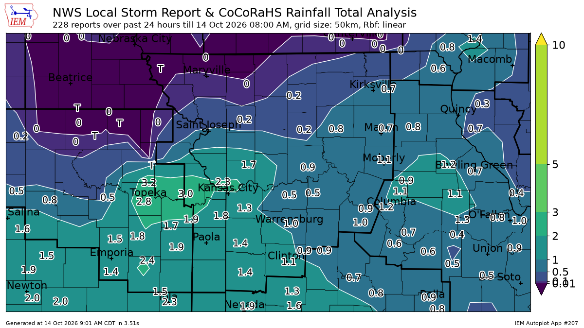 See Kansas City rainfall totals after overnight storms prompted tornado warning
Strong overnight storms brought heavy rain and damaging winds to the Kansas City area, leaving parts of the metro soaked with 1 to 2 inches of rain. Rainfall totals from automated weather stations show that several…
Air quality
Air quality is satisfactory, and air pollution poses little or no risk.
Topeka, KS reporting area · 1 hr ago. Data from AirNow (EPA and its state, local and tribal partners); preliminary and subject to change.
Sun & moon
Almanac
MonthlyTopeka Area, records since 1887. Normals 1991–2020. Data from NOAA's Regional Climate Centers (ACIS).
Nearby
- Lawrence 41 km
- Ottawa 60 km
- Eudora 53 km
- Tonganoxie 54 km
- Baldwin City 53 km
- Wamego 55 km
- Holton 48 km
- Osage City 46 km
- Saint Marys 37 km
Forecasters' discussion
From the National Weather Service office in TOP, issued 8 hrs ago
Key Messages
- Spotty showers or sprinkles are possible today and tonight. Slightly better rain chances (15-40%) come this weekend into early next week.
- A slow warming trend is expected the rest of this week before cooling down slightly early next week.
Discussion
Issued at 305 AM CDT Tue Oct 20 2026
Upper low continues to deepen off the Pacific coast with southwest flow aloft covering the Rockies and Plains. VAD wind profilers are indicative of a weaker shortwave in the OK/TX panhandle vicinity. A weak area of sfc low pressure is noted in the lee of the Rockies with weak isentropic ascent in OK and south central KS. In response to this, mid/high clouds are moving into the region with some light returns on radar, but only one observation of rain reaching the ground thus far in Wichita. Isentropic lift remains weak through the morning, but looks to increase somewhat into the afternoon with better upper support this evening and overnight from the passing shortwave. Overall, limited moisture through the column may mean less actual rainfall compared to what is shown on CAMs through the day today and overnight tonight. The thinking is that there is still enough to support a few light showers or sprinkles, which will likely be hit or miss over the next 24 hours, so have gone with a broad mention of this area-wide through early Wednesday morning. Otherwise, expect increasing cloud cover with enough southerly wind to keep high temperatures around 70 degrees.
Once the shortwave passes Wednesday morning, the upper ridge axis builds and inches closer to the area while the Pacific trough slowly moves onto the coast. This favors warmer temperatures for the middle and end of the work week, bringing highs to the mid and upper 70s while lows slowly climb through the 50s each morning. Models still diverge on their evolution of the western trough by the weekend, which results in differences in timing of the sfc front and associated rain chances. Some solutions are trying to stall the front nearby, or potentially still northwest of the area through the weekend and delay it until Monday. This leads to overall low confidence, low probability rain chances mainly in western portions of the area Saturday, which spread across the area into Monday. Temperatures overall trend a bit cooler (closer to seasonal norms) into early next week, but it remains to be seen exactly when we see that cool-down as spreads become larger Sunday and beyond.
Aviation
Issued at 544 AM CDT Tue Oct 20 2026
VFR conditions are forecast with increasing mid/high clouds this morning and persisting through the period. A few showers or sprinkles may move through terminals around midday and again later this evening and tonight, but this would be brief and would not have enough impact to mention in TAFs. Winds stay under 10 kts from the south to southeast.
Top Watches
None.
Forecasts, observations and alerts in the United States come from the National Weather Service (NOAA); radar from NOAA's Multi-Radar Multi-Sensor system; satellite imagery from NASA's Global Imagery Browse Services (GIBS) and NOAA's GOES satellites; the map from the U.S. Geological Survey's National Map; air quality from AirNow (EPA and its partners); hurricane information from the National Hurricane Center; climate normals and records from NOAA's Regional Climate Centers (ACIS). Forecasts outside the United States and the UV index: MET Norway (CC BY 4.0); observations outside the U.S.: airport reports via NOAA's Aviation Weather Center. Place names: GeoNames (CC BY 4.0). Data are copied on a schedule and may lag the sources; for warnings that affect your safety, follow your local National Weather Service office and emergency officials. Weather news is drawn from the 4Search index and reflects what the press published. Terms of use.