Install
Tonganoxie, KS Weather
Current conditions
Observed at Olathe, New Century Aircenter · 1 hr ago
Forecast
10-day-
Sunday Night
Mostly cloudy, with a low around 55. South southeast wind around 5 mph.
-
Monday
Mostly sunny, with a high near 78. South wind 3 to 9 mph.
-
Monday Night
Mostly cloudy, with a low around 56. South wind around 7 mph.
National Weather Service forecast updated 14 hrs ago.
Hourly
Hourly forecast- Now76°
- 7 PM72°
- 8 PM69°
- 9 PM64°
- 10 PM63°
- 11 PM62°
- Mon12 AM61°
- 1 AM59°
- 2 AM58°
- 3 AM58°
- 4 AM57°
- 5 AM56°
- 6 AM56°
- 7 AM55°
- 8 AM55°
- 9 AM57°
- 10 AM63°
- 11 AM68°
- 12 PM72°
- 1 PM75°
- 2 PM76°
- 3 PM76°
- 4 PM77°
- 5 PM76°
10-day forecast
Details- TonightOct 24Mostly Cloudy54°
- TodayOct 25Mostly Sunny55°80°
- MonOct 26Mostly Sunny10%56°78°
- TueOct 27Slight Chance Rain Showers15%57°73°
- WedOct 28Sunny20%60°79°
- ThuOct 29Slight Chance Showers And Thunderstorms20%60°81°
- FriOct 30Slight Chance Rain Showers28%59°78°
- SatOct 31Rain Showers Likely60%74°
- SunNov 1Light rain0.24 in63°75°
- MonNov 2Cloudy0.04 in59°81°
Days after the National Weather Service's seven are MET Norway's outlook, a computer model with no forecaster's review.
Radar
Full mapWeather news near Tonganoxie
More weather news-
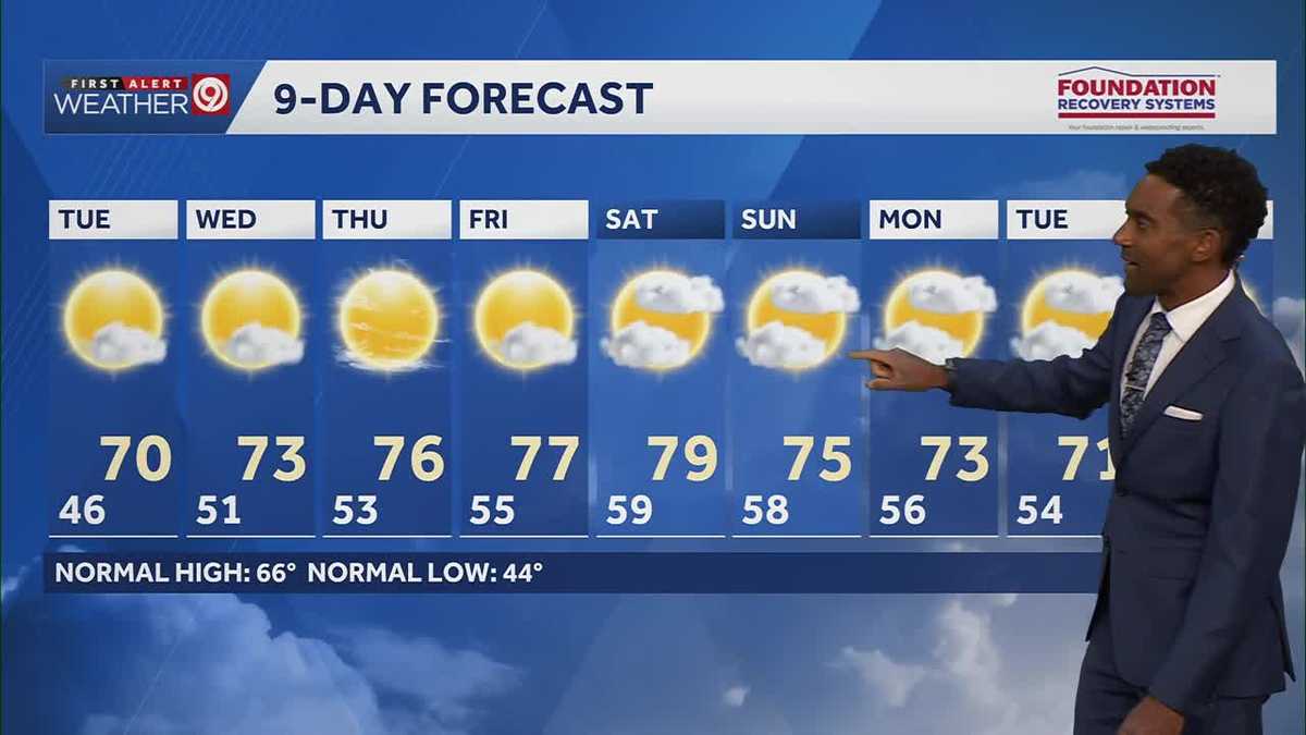 After a cool few days, warmer temperatures return starting Tuesday in Kansas City
After some cool and comfortable fall temperatures, things start to warm up once again for the rest of the week! Expect sunshine and dry conditions for the next few days. Tuesday will be partly cloudy with highs in the…
-
 KSHB 41 Weather | Sunshine and highs in the 60s Sunday in Kansas City
KSHB 41 Weather | Sunshine and highs in the 60s Sunday KSHB 41 Kansas City KSHB 41 Weather | Sunshine and highs in the 60s Sunday in Kansas City KANSAS CITY, Mo. — Hosting an event or gathering? Send your weather…
-
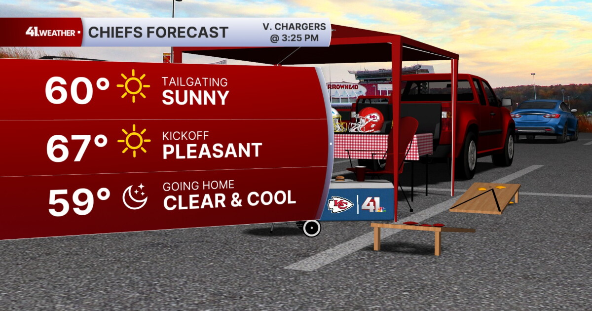 KSHB 41 Weather Blog | Pleasant stretch of weather in store for Kansas City
KANSAS CITY, Mo. — Pleasant, fall weather is sticking around for the next few days, before highs reach near 80° by the end of the week. Sunday is going to be the ideal fall day. Chilly in the morning, then reaching the…
-
 Fantastic fall Sunday, warmer days ahead
KCTV KANSAS CITY, Mo. (KCTV) - Chilly temperatures blanket the region for the start of your Sunday. SUNDAY: Sunshine is expected all day, so that will help our crisp fall conditions feel a bit more pleasant. We have a…
- Warmer & quiet pattern upcoming
First Warn: That First Fall Chill Is Here! KCTV KANSAS CITY, Mo. (KCTV) - After our coldest highs since March yesterday & lows since May 1st this morning, temps will slowly warm, with dry conditions likely persisting…
- Kansas City Weather Forecast: Freeze Watch Before 80-Degree Warmup
Kansas City was expected to wake to temperatures in the lower 40s Friday morning, with skies possibly clear at first and stratus potentially moving through, and a sharp north wind making the October air feel colder than…
-
 KSHB 41 Weather Blog | Sunny and cool over the weekend
KANSAS CITY, Mo. — After a chilly morning, Kansas City will turn out to be a bit more comfortable for the rest of the weekend. After a cold start in the 30s for most across the area, temperatures will start to warm up…
-
 KSHB 41 Weather | A cool and sunny weekend forecast
A cool and sunny weekend forecast KSHB 41 Kansas City Hosting an event or gathering? Send your weather question to Lauren, Wes, Caleb and Jade by sending an email to [email protected].âWEATHER HEADLINESA sunny, cool…
-
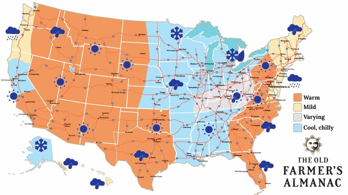 Snow, Rain or Sun? Old Farmer’s Almanac Thanksgiving Weather Forecast 2026, Region by Region
The Old Farmer’s Almanac released its 2026 Thanksgiving weather forecast for the United States. It calls for a mix of snow, rain, and sunshine on Thursday, November 26. The Almanac published the outlook on October 15…
-
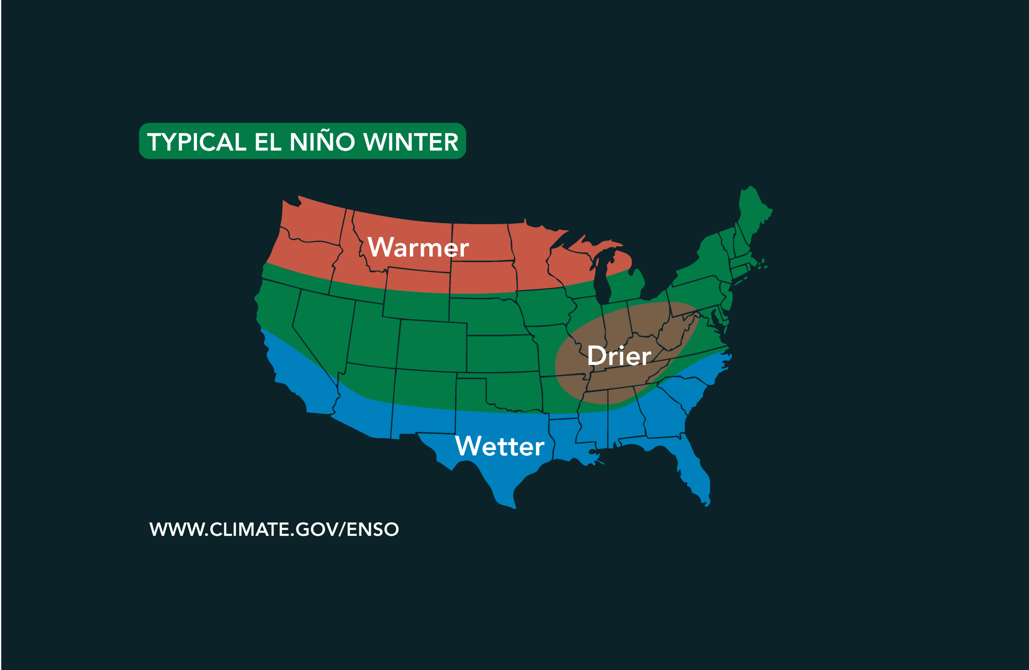 Potential El Niño to affect Kansas agriculture
Student critically injured after falling 70 feet in effort to avoid incoming vehicle • 2338 views College of Arts and Sciences to face future budget cuts • 2090 views K-State President Richard Linton to leave Wildcats…
Air quality
Acceptable. Unusually sensitive people should consider limiting prolonged outdoor exertion.
Forecast
- SunModerate (51)
- MonModerate (58)
Kansas City, MO reporting area · 1 hr ago. Data from AirNow (EPA and its state, local and tribal partners); preliminary and subject to change.
Sun & moon
Almanac
MonthlyLawrence, records since 1868. Normals 1991–2020. Data from NOAA's Regional Climate Centers (ACIS).
Nearby
- Kansas City 44 km
- Overland Park 39 km
- Kansas City 40 km
- Olathe 34 km
- Topeka 51 km
- Independence 58 km
- Lawrence 20 km
- Shawnee 33 km
- Lenexa 35 km
- Leavenworth 27 km
- Leawood 44 km
- Liberty 60 km
Forecasters' discussion
From the National Weather Service office in EAX, issued 4 hrs ago
Key Messages
- Above normal temperatures through the week, but trending closer to normal for the weekend.
- Isolated to scattered showers Tuesday.
- Scattered to widespread showers, possibly a few thunderstorms, Friday through Sunday.
Discussion
Issued at 149 PM CDT Sun Oct 25 2026
Upper-level ridging will shift eastward and become less amplified Monday into Tuesday. This will will allow a short wave trough to move out of Mexico and southwestern Texas and into the Middle to Lower Missouri valley by Tuesday evening. Forcing associated with this shortwave may be enough to wring out the marginal moisture available to the system. As a result, isolated to scattered showers, and potentially a thunderstorm or two, look possible during the day across eastern Kansas and western Missouri. The potential for measurable rainfall is about 20-30%. The potential for any storms is still very low and generally less than 10%. So, while there is some potential, it's more than likely just going to be showers moving through, if there is any precipitation.
Otherwise, above normal temperatures will continue. For the Kansas City area, normal high temperatures range from 63 on Monday, to 60 by Sunday. Forecast highs on Monday are in the upper 70s, about 15 degrees above normal for this time of year. Temperatures drop off slightly on Tuesday with the shortwave and associated cloud cover and precipitation chances moving into the area through the day. For the middle part of the work week, while the ridging remains mostly situated southeast of the region, persistent southerly flow around the ridging/ surface high to our southeast, will maintain warm advection across the Southern and Central Plains. So it looks likely we'll see highs rebound back into the upper 70s to potentially lower 80s, about 15-20 degrees above normal. Late in the week, precipitation chances start to increase, with scattered to widespread rainfall by Saturday. Thursday, a front sags southward into the area, pushed southward by a shortwave tracking across the Northern Plains and Upper Midwest. That front interacts with increasing moisture from the persistent southerly flow to give us our increasing precipitation chances. For the weekend, a series of waves moves through the area, with front still in the vicinity. With broad upper forcing, the boundary in the area, and moisture available, we should see scattered to widespread showers Friday night into Saturday. Right now, it looks like a 40-60% chance for rain from Saturday afternoon into Saturday evening, with decreasing chances after midnight. So umbrellas may be needed for anyone outside during that time frame. Still, though it looks like we'll see scattered to widespread precipitation, rain amounts look relatively low through the weekend. For the 48 hour period ending at 6 am Sunday morning, there is roughly a 1 in 3 (30-35%) chance for rain amounts exceeding 1 inch and just over a coin flip (50-60%) for exceeding half an inch.
Aviation
Issued at 1159 AM CDT Sun Oct 25 2026
VFR conditions are expected through the forecast. Scattered to broken high-level clouds will stream over the area with light southerly surface winds around 5kts through the entire forecast period.
Eax Watches
MO...None. KS...None.
Forecasts, observations and alerts in the United States come from the National Weather Service (NOAA); radar from NOAA's Multi-Radar Multi-Sensor system; satellite imagery from NASA's Global Imagery Browse Services (GIBS) and NOAA's GOES satellites; the map from the U.S. Geological Survey's National Map; air quality from AirNow (EPA and its partners); hurricane information from the National Hurricane Center; climate normals and records from NOAA's Regional Climate Centers (ACIS). Forecasts outside the United States and the UV index: MET Norway (CC BY 4.0); observations outside the U.S.: airport reports via NOAA's Aviation Weather Center. Place names: GeoNames (CC BY 4.0). Data are copied on a schedule and may lag the sources; for warnings that affect your safety, follow your local National Weather Service office and emergency officials. Weather news is drawn from the 4Search index and reflects what the press published. Terms of use. How to use Weather