Install
Macon, GA 31205 Weather
Current conditions
Forecast for this hour (no station report in the last two hours)
Forecast
10-day-
This Afternoon
Sunny, with a high near 79. Northeast wind around 5 mph.
-
Tonight
Clear, with a low around 47. Northeast wind 0 to 5 mph.
-
Friday
Sunny, with a high near 75. Northeast wind 5 to 10 mph.
National Weather Service forecast updated 1 hr ago.
Hourly
Hourly forecast- Now78°
- 4 PM78°
- 5 PM78°
- 6 PM74°
- 7 PM69°
- 8 PM64°
- 9 PM60°
- 10 PM58°
- 11 PM55°
- Fri12 AM54°
- 1 AM52°
- 2 AM51°
- 3 AM51°
- 4 AM49°
- 5 AM48°
- 6 AM48°
- 7 AM48°
- 8 AM48°
- 9 AM51°
- 10 AM58°
- 11 AM65°
- 12 PM69°
- 1 PM72°
- 2 PM74°
10-day forecast
Details- TodayOct 22Sunny47°79°
- FriOct 23Sunny47°75°
- SatOct 24Sunny47°74°
- SunOct 25Sunny48°73°
- MonOct 26Sunny44°75°
- TueOct 27Sunny44°77°
- WedOct 28Mostly Sunny49°76°
- ThuOct 29Cloudy0.03 in60°78°
- FriOct 30Mostly sunny56°80°
- SatOct 31Sunny56°77°
Days after the National Weather Service's seven are MET Norway's outlook, a computer model with no forecaster's review.
Radar
Full mapWeather news near Macon
More weather news-
 Dry weather leads to possible High Fire Danger Conditions
41NBC News Dry weather leads to possible High Fire Danger Conditions MACON, Georgia (41NBC/WMGT) – High pressure over the southeast is expected to sit and spin in place through the rest of the work week. There is no…
-
 A beautiful stretch of Fall weather ahead
41NBC News A beautiful stretch of Fall weather ahead MACON, Georgia (41NBC/WMGT) – A Fire Danger Statement is in effect for portions of North and Middle Georgia through 8 PM this evening. Autumn, it would appear, is…
-
 First Alert: Looking ahead to a sunny and seasonable next several days
MONTGOMERY, Ala. (WSFA) - Conditions have turned much quieter across central and southern Alabama over the past several days, and that very quiet pattern is expected to stick around for the ... MONTGOMERY, Ala. (WSFA)…
- Sunny Atlanta Turns Tinderbox As Dry Winds Trigger High Fire Danger
The National Weather Service’s Peachtree City office says humidity could fall to 30% or lower for at least four hours Sunday afternoon into the evening, while northeast winds run 10 to 15 mph with gusts up to 20 to 25…
-
 First freeze of fall expected in western North Carolina mountains Sunday morning
A Frost Advisory is in effect Sunday morning from 1 AM to 9 AM for the southern NC mountains, eastern foothills, Upstate SC, and NE Georgia. A Freeze Warning is in effect Sunday morning from 1 AM to 9 AM for counties…
- Cold front will send Georgia temperatures plunging this weekend
Georgia is in for a noticeable cooldown this weekend, with temperatures expected to fall by more than 20 degrees in some parts of the state from a strong cold front. The National Weather Service forecast calls for sunny…
-
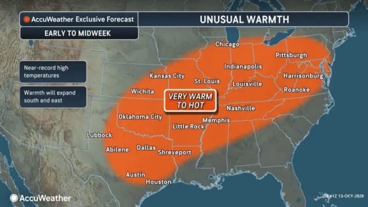 Georgia just broke heat records, what happened to fall?
Georgia just broke October heat records, and if you've been wondering when fall is finally going to arrive, you'll have to wait just a little longer. Wednesday, Oct. 14, brought another round of unusually warm weather…
-
 Crisp Fall temperatures finally reach Middle Georgia this weekend
41NBC News Crisp Fall temperatures finally reach Middle Georgia this weekend MACON, Georgia (41NBC/WMGT) – The main story for the weekend will be a sharp cold front pushing through North and Middle Georgia later today…
-
 Where are the Fall colors? | When Central Georgia can expect peak foliage
MACON, Ga. — Fall is officially here, but it doesn't necessarily feel like it, and with cooler temperatures on the way this weekend, many across Central Georgia may be wondering when we'll begin seeing those beautiful…
- Atlanta Weather: 88 Degrees Before Weekend Chill
Atlanta is starting Thursday clear and in the mid-60s, with one more summerlike afternoon ahead before fall finally barges in. Temperatures are expected to climb to around 88 degrees under sunny skies, while the weekend…
Air quality
Acceptable. Unusually sensitive people should consider limiting prolonged outdoor exertion.
Forecast
- ThuGood (44)
- FriGood (46)
Macon, GA reporting area · 1 hr ago. Data from AirNow (EPA and its state, local and tribal partners); preliminary and subject to change.
Sun & moon
Almanac
MonthlyMacon Area, records since 1892. Normals 1991–2020. Data from NOAA's Regional Climate Centers (ACIS).
Nearby
- Warner Robins 22 km
- Milledgeville 53 km
- Perry 39 km
- Fort Valley 34 km
- Centerville 20 km
- Barnesville 51 km
- Byron 18 km
- Jackson 60 km
- Cochran 56 km
- Forsyth 34 km
- Hardwick 52 km
- Gray 27 km
Forecasters' discussion
From the National Weather Service office in FFC, issued 1 hr ago
Key Messages
- Elevated fire danger conditions will likely persist for at least parts of the area through Friday afternoon due to low relative humidity.
- Rain-free conditions and near-seasonal temperatures will remain for the next 7 days, with a slight cool-down Friday through early next week.
Short Term
(This afternoon through Friday) Issued at 159 PM EDT Thu Oct 22 2026
Dry conditions and pleasant temperatures (within about 5 degrees of seasonal normals) are expected through tomorrow (Friday) night. Northerly flow aloft and high pressure across the Southeast will maintain zero chance for rain and very little in the way of clouds. Another Fire Danger Statement is in effect across most of north and central Georgia this afternoon and evening due to low relative humidity and dry fuels. Similar conditions tomorrow will lead to low relative humidity likely supportive of yet another Fire Danger Statement across at least parts of the forecast area. While winds remain relatively light, the dry air could support rapid fire development.
High temperatures tomorrow are forecast to be around 4-8 degrees cooler than those today, as something of a cold air damming "wedge" pushes across the forecast area with surface/low-level easterly winds and weak cold air advection (CAA) in tow.
Long Term
(Saturday morning through next Wednesday) Issued at 159 PM EDT Thu Oct 22 2026
Continued Dry and Mild Conditions:
High pressure continues to dominate the weather pattern into the the extended periods with high temps in the 70s and lows in the 40s. By Sat morning the main ridge will be centered over the New England states with its axis angled SW down the eastern seaboard and out across the LA/MS gulf coast. This ridge stays fairly stationary through the weekend with only a slight movement to just off the MA/ME coast line by Mon morning. This will but GA in more of an E to NE flow pattern and we could see a little bit of moisture return across the area from the Atlantic going into next week. As for now only expecting increased cloud cover across the state days 5 through 7. This ridge does weaken a bit by Tue/Wed as an approaching low pressure system moves E out of the Central Plains. The main low center is expected to track across the central Great Lake states Wed and into the New England states Thu morning. Its associated cold frontal boundary moves into NW GA around daybreak Wed and quickly sweeps through the state exiting the GA coast by sunset. The good dynamics and moisture with the front all push NE closer to the parent low center allowing this dry cold front to push through the SERN U.S. keeping things dry for north and central GA.
Aviation
(18Z TAFS) Issued at 105 PM EDT Thu Oct 22 2026
VFR conditions will prevail through the TAF period. Winds will be light (generally less than 6 kts) and variable in direction through tonight, likely waffling on either side of due north at times at ATL. Winds will pick up at 5-10 kts out of the ENE tomorrow (Friday) morning into afternoon.
//ATL Confidence...18Z Update... High confidence on all elements.
Martin
Forecasts, observations and alerts in the United States come from the National Weather Service (NOAA); radar from NOAA's Multi-Radar Multi-Sensor system; satellite imagery from NASA's Global Imagery Browse Services (GIBS) and NOAA's GOES satellites; the map from the U.S. Geological Survey's National Map; air quality from AirNow (EPA and its partners); hurricane information from the National Hurricane Center; climate normals and records from NOAA's Regional Climate Centers (ACIS). Forecasts outside the United States and the UV index: MET Norway (CC BY 4.0); observations outside the U.S.: airport reports via NOAA's Aviation Weather Center. Place names: GeoNames (CC BY 4.0). Data are copied on a schedule and may lag the sources; for warnings that affect your safety, follow your local National Weather Service office and emergency officials. Weather news is drawn from the 4Search index and reflects what the press published. Terms of use.