Install
Colchester, VT 05439 Weather
Current conditions
Forecast for this hour (no station report in the last two hours)
Forecast
10-day-
Saturday
Sunny, with a high near 59. Southwest wind around 2 mph.
-
Saturday Night
Clear, with a low around 30. Southeast wind around 3 mph.
-
Sunday
Sunny, with a high near 62. South wind 3 to 7 mph.
National Weather Service forecast updated 1 day ago.
Hourly
Hourly forecast- Now29°
- 8 AM33°
- 9 AM38°
- 10 AM43°
- 11 AM48°
- 12 PM52°
- 1 PM55°
- 2 PM56°
- 3 PM57°
- 4 PM59°
- 5 PM55°
- 6 PM51°
- 7 PM47°
- 8 PM44°
- 9 PM42°
- 10 PM40°
- 11 PM38°
- Sun12 AM37°
- 1 AM36°
- 2 AM35°
- 3 AM34°
- 4 AM33°
- 5 AM33°
- 6 AM32°
10-day forecast
Details- ThuOct 22Mostly Sunny31°55°
- FriOct 23Sunny29°54°
- TodayOct 24Sunny30°59°
- SunOct 25Sunny39°62°
- MonOct 26Mostly Sunny35°60°
- TueOct 27Mostly Sunny28°50°
- WedOct 28Mostly Sunny34°52°
- ThuOct 29Cloudy0.02 in45°59°
- FriOct 30Partly cloudy0.23 in42°54°
- SatOct 31Partly cloudy40°52°
Days after the National Weather Service's seven are MET Norway's outlook, a computer model with no forecaster's review.
Radar
Full mapWeather news near Colchester
More weather news-
 Top wind gusts Friday before cold air filters into the region this evening
BURLINGTON, Vt. (WCAX) - A strong cold front swept through northern New York and Vermont Friday morning into early afternoon, bringing the strongest wind gusts of the fall so far. Our crews found storm damage across…
-
 NOAA’s Winter Outlook Predicts Warmer Temperatures and Less Snow for Vermont
At SSBCrack News, our dedicated editorial team brings you the latest and most reliable updates on Defence, Geopolitics, Military Affairs, Science, and Technology. Driven by a passion for national security and strategic…
- Vermont Woolly Bear Points to Mild Winter in Predicting A Harsh Winter Using Wildlife
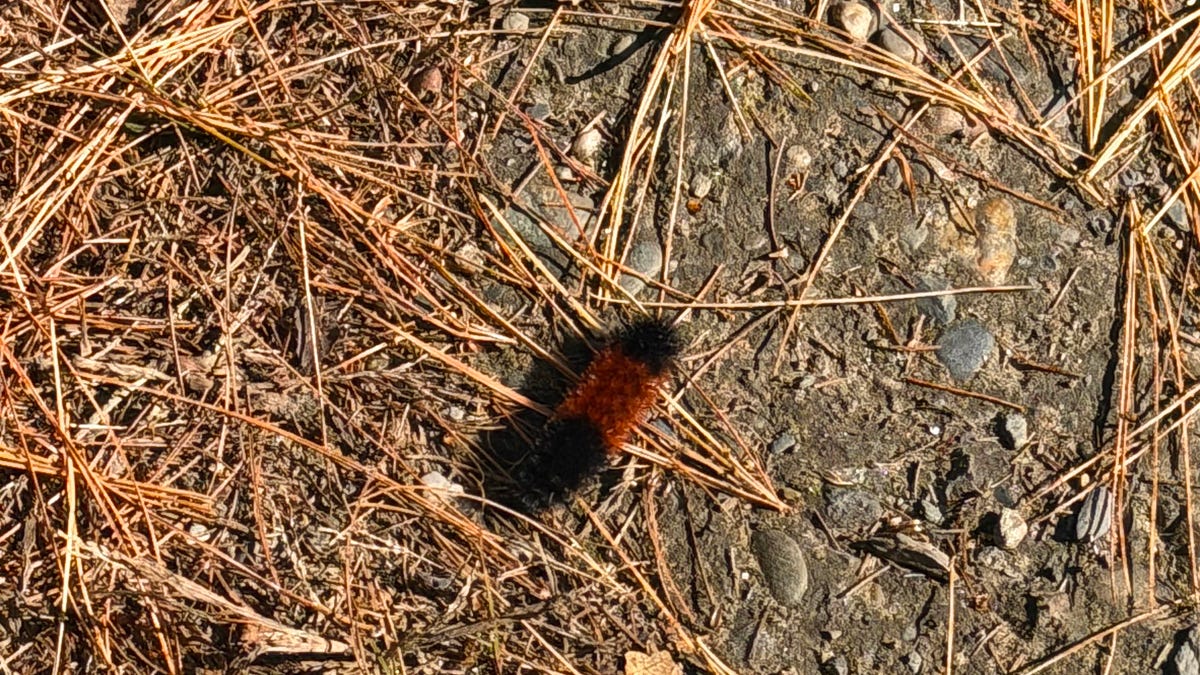
A Vermont woolly bear crossing a patch of pine needles on an access road this week is feeding the old habit of predicting a harsh winter using wildlife, and this one pointed toward a mild season. Its black ends and wide…
-
 PHOTOS: First snowflakes fly around Vermont
VTDigger Member-supported journalism. Informing and engaging Vermont. This year, VTDigger is teaming up with Henry’s Weather Channel to help answer the annual question of when and where peak foliage will make its…
-
 A Vermont Woolly Bear Calls for a Mild Winter. NOAA Mostly Agrees.
The federal government released its official winter forecast on Thursday. Compass Vermont got a second opinion from a caterpillar. We found him crossing a patch of pine needles on a Vermont access road this week. He’s a…
Air quality
Air quality is satisfactory, and air pollution poses little or no risk.
Forecast
- SatGood (40)
Burlington, VT reporting area · 2 hrs ago. Data from AirNow (EPA and its state, local and tribal partners); preliminary and subject to change.
Sun & moon
Almanac
MonthlyBurlington Area, records since 1883. Normals 1991–2020. Data from NOAA's Regional Climate Centers (ACIS).
Nearby
- Burlington 4 km
- Plattsburgh 32 km
- South Burlington 3 km
- Essex Junction 4 km
- Williston 10 km
- Montpelier 54 km
- Winooski 2 km
- Saint Albans 36 km
- Middlebury (village) 53 km
- Morristown 43 km
- Hinesburg 19 km
- Stowe 38 km
Forecasters' discussion
From the National Weather Service office in BTV, issued 11 hrs ago
What Has Changed
As of 210 PM EDT Friday...
No significant changes have been made to the forecast.
Key Messages
As of 210 PM EDT Friday...
1. Dry and quiet weather will continue into the start of next week, with seasonably warm temperatures expected
2. Dry weather will persist much of next week with high pressure slowly crossing the region.
Discussion
As of 210 PM EDT Friday...
KEY MESSAGE 1: The stretch of dry and quiet weather will persist across the region as high pressure continues to build into the region, with the center of the high overhead tomorrow into Sunday before gradually shifting eastward. Ideal radiational cooling conditions will allow for some cold overnight lows tonight, with temperatures dropping into the teens and 20s, likely a few degrees cooler than the last few nights. Temperatures will gradually moderate throughout the weekend, with high temperatures warming into the lower 60s for Sunday and Monday. Dewpoints will be fairly low, dropping into the 20s or so, but no fire weather concerns are anticipated given the lack of winds across the region with the high pressure overhead. A weak cold front looks to move through the region on Monday, but with such dry air ahead of the feature and lack of moisture, no precipitation is expected just a slight increase in cloud cover.
KEY MESSAGE 2: Our prolonged period of dry weather will continue through at least the middle part of next week as sprawling high pressure returns on Tuesday. Longer range models continue to show another cold frontal passage late week, accompanied by light QPF. Given the lack of a deep plume of moisture ahead of this front, wouldn't be surprised if we get nothing but a period of increased cloud cover, much like our frontal passage yesterday. Still, it's a week out, so have stayed with the NBM/WPC forecast for now, which gives low chances of showers late next week. Temperatures will remain seasonable, coolest on Tuesday but warming as the week progresses.
Aviation
Through 00Z Sunday...VFR conditions will prevail through the entire TAF period. The potential for fog is fairly low due to our recent dry spell, but could briefly occur between 10z and 12z at KMSS, KSLK, or KMPV. Reductions in visibility, if any, will likely last no longer than a half hour. Some passing high clouds will be possible, but high pressure will be centered over our region. Winds will be light and variable over the next 24 hours.
Outlook...
Saturday Night: VFR. NO SIG WX. Sunday: VFR. NO SIG WX. Sunday Night: VFR. NO SIG WX. Monday: Mainly VFR, with local MVFR possible. NO SIG WX. Monday Night: VFR. NO SIG WX. Tuesday: VFR. NO SIG WX. Tuesday Night: VFR. NO SIG WX. Wednesday: VFR. NO SIG WX.
Forecasts, observations and alerts in the United States come from the National Weather Service (NOAA); radar from NOAA's Multi-Radar Multi-Sensor system; satellite imagery from NASA's Global Imagery Browse Services (GIBS) and NOAA's GOES satellites; the map from the U.S. Geological Survey's National Map; air quality from AirNow (EPA and its partners); hurricane information from the National Hurricane Center; climate normals and records from NOAA's Regional Climate Centers (ACIS). Forecasts outside the United States and the UV index: MET Norway (CC BY 4.0); observations outside the U.S.: airport reports via NOAA's Aviation Weather Center. Place names: GeoNames (CC BY 4.0). Data are copied on a schedule and may lag the sources; for warnings that affect your safety, follow your local National Weather Service office and emergency officials. Weather news is drawn from the 4Search index and reflects what the press published. Terms of use.