Install
Sun Prairie, WI Weather
Current conditions
Observed at Madison, Dane County Regional-Truax Field · 1 hr ago
Forecast
10-day-
Friday Night
Partly cloudy, with a low around 52. South wind around 5 mph.
-
Saturday
Partly sunny, with a high near 72. South wind 5 to 15 mph.
-
Saturday Night
Mostly cloudy, with a low around 53. South wind 5 to 10 mph.
National Weather Service forecast updated 1 day ago.
Hourly
Hourly forecast- Now66°
- 7 PM64°
- 8 PM61°
- 9 PM59°
- 10 PM57°
- 11 PM56°
- Sat12 AM55°
- 1 AM54°
- 2 AM53°
- 3 AM53°
- 4 AM53°
- 5 AM52°
- 6 AM52°
- 7 AM52°
- 8 AM54°
- 9 AM56°
- 10 AM59°
- 11 AM62°
- 12 PM66°
- 1 PM69°
- 2 PM70°
- 3 PM71°
- 4 PM71°
- 5 PM69°
10-day forecast
Details- TonightOct 21Clear then Patchy Fog46°
- ThuOct 22Patchy Fog then Sunny47°72°
- TodayOct 23Mostly Sunny52°72°
- SatOct 24Partly Sunny53°72°
- SunOct 25Partly Sunny50°71°
- MonOct 26Partly Sunny then Slight Chance Rain Showers25%43°62°
- TueOct 27Chance Rain Showers29%43°58°
- WedOct 28Partly Sunny13%62°
- ThuOct 29Rain0.06 in41°49°
- FriOct 30Cloudy34°52°
Days after the National Weather Service's seven are MET Norway's outlook, a computer model with no forecaster's review.
Radar
Full mapWeather news near Sun Prairie
More weather news-
 A calmer, mild week ahead for north central Wisconsin
It's another quiet day across the region with mainly sunny to partly cloudy skies. Plenty more of these days are to come. WAUSAU, Wis. (WSAW) - If you enjoyed all the sunshine over the weekend, get used to plenty more…
-
 A very quiet and unfall-like week ahead
MADISON, Wis. (WMTV) - Sunshine is sticking around for the rest of Sunday afternoon across southern Wisconsin, with temperatures climbing into the lower and mid-60s. Madison should reach around 62 degrees, a noticeable…
-
 Sunshine brings late October warmth
Sunshine continues Saturday afternoon, with highs reaching the middle and upper 50s - A warming trend could push temperatures into the 70s by the middle of next week MADISON, Wis. (WMTV) - After Saturday got off to a…
-
 Madison braces for freezing temperatures on heels of record heat
Wisconsin State Journal Javascript is required to use this website. Wisconsin is in for a chilly night. People are also reading⦠- Hereâs where grocery giant Woodmanâs wants to build its next store - Remnants of…
-
 First Freeze Tonight, Then a Big Warmup
WMTV 15 NEWS MADISON, Wis. (WMTV) -Blustery and chilly conditions continue this afternoon, with scattered showers gradually ending from northwest to southeast. A few showers could even contain graupel or small ice…
-
 Dangerous Freeze Warnings Issued for Iowa, Wisconsin, Minnesota and Illinois as Temperatures Drop
Freeze Warnings take effect early Saturday across much of Iowa, Wisconsin, southeast and central Minnesota and northern Illinois, with lows as cold as 26 degrees expected. Seven National Weather Service offices issued…
-
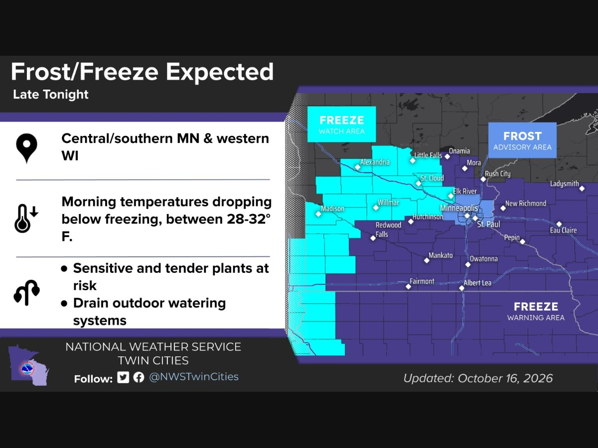 Frost Advisory, Freeze Warning Issued For Parts Of MN: See Map
MINNEAPOLIS, MN — Frost and freezing temperatures are expected across much of Minnesota and western Wisconsin late Friday night into Saturday morning, according to the National Weather Service. A Frost Advisory is in…
-
 Friday winds, Saturday freeze
MADISON, Wis. (WMTV) - We’re waking up to a windy and chilly Friday across southern Wisconsin, with a few scattered showers possible through the morning. Northwest winds will frequently gust between 30 and 40 mph, while…
-
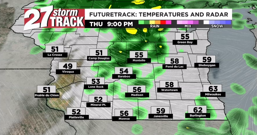 Scattered showers continue as temperatures continue to cool
Scattered rainfall will continue on and off throughout the evening and into our Friday. By the time itâs all said and done late Friday morning or early tomorrow afternoon, some of us will have received more than an…
-
 Rain Likely Today, Tonight & Friday
WMTV 15 NEWS MADISON, Wis. (WMTV) - Rain will take center stage across South Central Wisconsin today, with periods of showers expected through the afternoon and into tonight. Rainfall totals will vary, but some…
Air quality
Acceptable. Unusually sensitive people should consider limiting prolonged outdoor exertion.
Forecast
- FriModerate
- SatModerate
- SunModerate
Madison Area, WI reporting area · 1 hr ago. Data from AirNow (EPA and its state, local and tribal partners); preliminary and subject to change.
Sun & moon
Almanac
MonthlyMadison Area, records since 1869. Normals 1991–2020. Data from NOAA's Regional Climate Centers (ACIS).
Nearby
- Madison 20 km
- Janesville 58 km
- Fitchburg 32 km
- Watertown 39 km
- Middleton 25 km
- Beaver Dam 43 km
- Oconomowoc 59 km
- Whitewater 55 km
- Waunakee 20 km
- Stoughton 30 km
- Verona 34 km
- Fort Atkinson 42 km
Forecasters' discussion
From the National Weather Service office in MKX, issued 4 hrs ago
Key Messages
- Lingering fog along the immediate Lake Michigan shoreline through mid-afternoon (~3 PM).
- Above normal temperatures & rain-free conditions continue into the weekend.
- Temperatures closer to normal next week, with chances for rain northwest Monday night/Tuesday & areawide at some point Wednesday through Friday.
Short Term
Issued 200 PM CDT Fri Oct 23 2026
This Afternoon through Saturday Night:
Synopsis/Mesoanalysis: Low pressure is centered over northeastern Montana this afternoon. Water vapor imagery places an upper trough over the north-central Rocky Mountains. The trough will eject northeast into the Canadian Prairies tonight, allowing the surface low to concurrently deepen and build northeast. Both the low and the upper trough will continue on toward the Hudson Bay Saturday night, pulling a cold front into the western Great Lakes in the process. The front will remain north of the region through Saturday night/the conclusion of the short term period, with prefrontal southwesterly winds maintaining above normal high temperatures.
This Afternoon: Areas of fog will continue to linger along the immediate Lake Michigan shoreline through ~3 PM. Persistent southeasterly surface flow has helped maintain marine fog longer than modeled by forecast guidance, with the western edge of the fog bank leaking into portions of the immediate lakeshore areas in Ozaukee, Milwaukee, Racine and Kenosha Counties. Abrupt drops in visibility have been noted in these areas, with drastic improvements to full visibility occurring just a few miles inland. Given the impactful but limited areal scope of the inland fog, have handled pockets of lakeshore fog with a Special Weather Statement through 3 PM. With satellite trends showing steady erosion of the responsible marine fog bank, not expecting the need to extend this statement beyond 3 PM or upgrade to any Dense Fog Advisories at this time. Slow down, use low beam headlights, and allow for extra following distance if traveling lakeside through early afternoon.
Tonight: Will need to watch for some patchy fog across far northeastern parts of the CWA. More widespread fog potential should be curbed by increasing southerly winds as the surface pressure gradient tightens ahead of the developing Canadian Prairies surface low. Will be monitoring visibility trends. Increasing warm advection in the 925-700 mb layer will support increasing mid-upper level clouds, with any appreciable rain chances expected to remain over northern Wisconsin. Will be monitoring for any possible changes into this evening.
Quigley
Long Term
Issued 200 PM CDT Fri Oct 23 2026
Sunday through Friday:
Synopsis: The cold front lingering to the north of the region will progress through the area on Sunday, slowly washing out in the process. North-northeast winds will become established in the wake of the boundary, and will be reinforced into Monday as high pressure moves into Ontario from the Canadian Prairies. Affiliated with upper troughing currently moving into southern California, an upper wave will slowly eject from the Rockies into the Northern Plains on Monday. The wave will deamplify as it tries to work toward northern Wisconsin on Tuesday, decaying over the general vicinity Tuesday night. Rain is possible in the vicinity of the upper wave Monday night into Tuesday, particularly over the northwest half of the area. Uncertainty increases---both in deterministic and ensemble guidance---moving into the mid-late portions of next week, with an upper trough & affiliated surface front expected to move through the western Great Lakes at some point during the Wednesday-Friday time frame. Amplitude, strength, and precise passage timing of the features remain uncertain, making it difficult to offer exact details regarding precipitation chances and any post-frontal temperature drops at this time. Will continue to provide updates as trends clarify over coming forecasts.
Monday night into Tuesday: Will be monitoring for possible rain chances ahead of an approaching upper shortwave. General consensus depicted in guidance is for the wave to induce weak surface cyclogenesis from the Dakotas into Iowa, with rain blossoming along the northeast periphery of the surface low where 1) mid-level DPVA and 2) frontogenesis will be maximized in the 1000-700 mb layer. Some uncertainty remains regarding where exactly these forcing mechanisms will overlap, with the strength of high pressure in the Ohio Valley being the primary northwest-southeast modulator of precip placement. As of this forecast, appears that the northwest half of the area will be most favored for precip, as this is where separation from the Ohio Valley high pressure will be greatest. Blended precip probability solution from the NBM thus appears reasonable at this time, and has been largely maintained in the afternoon update. Will continue to provide updates in coming forecasts.
Wednesday through Friday: Expecting that rain chances & cooler temperatures will return areawide at some point as an upper trough and cold front move through the region. Primary question is that of timing, with a number of different solutions evident in current global forecast guidance. As such, blended precip probabilities from the current NBM depict a wide range of chance (~20-40%) rain potential during this portion of the period, when in reality a narrower window of widespread rain potential will emerge as the forecast picture clarifies into next week. With a multitude of potential solutions in place & none more favored than the other, have maintained the wider window of precip potential in the afternoon update. Will continue to monitor trends into next week.
Quigley
Aviation
Issued 200 PM CDT Fri Oct 23 2026
Predominantly VFR flight categories prevail through the period at all terminals. Earlier day fog has largely dissipated region-wide, though VIS reductions continue to linger along the immediate Lake Michigan shoreline. While said reductions have remained east of MKE and ENW, they have resulted in reports of FEW clouds based near FL010 at MKE. Have accounted for these trends near-term at MKE, with the expectation for VIS reductions to remain largely in place/without any inland expansion prior to their dissipation later this afternoon. SCT to BKN mid-upper level clouds will gradually build in tonight into Saturday as a disturbance moves from the Northern Plains toward Lake Superior. Not anticipating any precipitation with this disturbance at this time.
Quigley
Forecasts, observations and alerts in the United States come from the National Weather Service (NOAA); radar from NOAA's Multi-Radar Multi-Sensor system; satellite imagery from NASA's Global Imagery Browse Services (GIBS) and NOAA's GOES satellites; the map from the U.S. Geological Survey's National Map; air quality from AirNow (EPA and its partners); hurricane information from the National Hurricane Center; climate normals and records from NOAA's Regional Climate Centers (ACIS). Forecasts outside the United States and the UV index: MET Norway (CC BY 4.0); observations outside the U.S.: airport reports via NOAA's Aviation Weather Center. Place names: GeoNames (CC BY 4.0). Data are copied on a schedule and may lag the sources; for warnings that affect your safety, follow your local National Weather Service office and emergency officials. Weather news is drawn from the 4Search index and reflects what the press published. Terms of use.