Install
Newport News, VA Weather
Current conditions
Forecast for this hour (no station report in the last two hours)
Forecast
10-day-
Today
Patchy fog between 8am and 9am. Sunny, with a high near 69. North wind 1 to 7 mph.
-
Tonight
Clear, with a low around 52. West wind 1 to 7 mph.
-
Tuesday
Sunny, with a high near 68. North wind around 9 mph.
National Weather Service forecast updated 12 hrs ago.
Hourly
Hourly forecast- Now68°
- 5 PM66°
- 6 PM64°
- 7 PM62°
- 8 PM60°
- 9 PM59°
- 10 PM57°
- 11 PM56°
- Tue12 AM54°
- 1 AM54°
- 2 AM53°
- 3 AM53°
- 4 AM53°
- 5 AM53°
- 6 AM52°
- 7 AM52°
- 8 AM53°
- 9 AM57°
- 10 AM61°
- 11 AM63°
- 12 PM65°
- 1 PM66°
- 2 PM66°
- 3 PM67°
Daily forecast
Details- TodayOct 26Patchy Fog then Sunny52°69°
- TueOct 27Sunny55°68°
- WedOct 28Mostly Sunny58°67°
- ThuOct 29Mostly Sunny57°70°
- FriOct 30Sunny58°72°
- SatOct 31Partly Sunny61°70°
- SunNov 1Chance Rain Showers36%62°70°
- MonNov 2Cloudy63°70°
- TueNov 3Partly cloudy61°69°
Days after the National Weather Service's seven are MET Norway's outlook, a computer model with no forecaster's review.
Radar
Full mapWeather news in Virginia
More weather news-
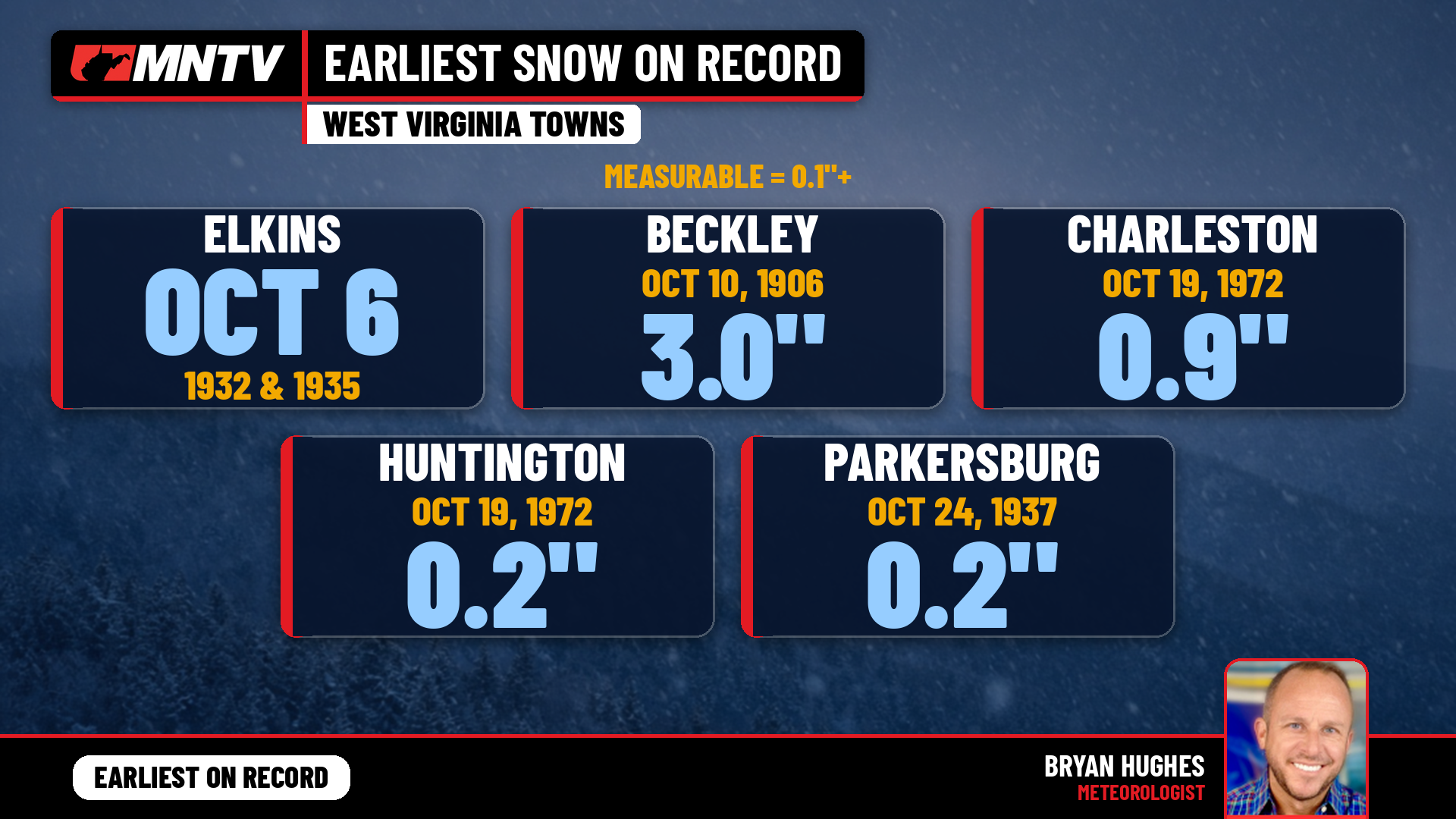 When does West Virginia usually see its first snow? Earlier than you might think
Every fall somebody asks the same question: when does the first snow usually show up in West Virginia? It’s a fair one. Leaves are still hanging on in a lot of places, football season is in full swing, and Halloween…
-
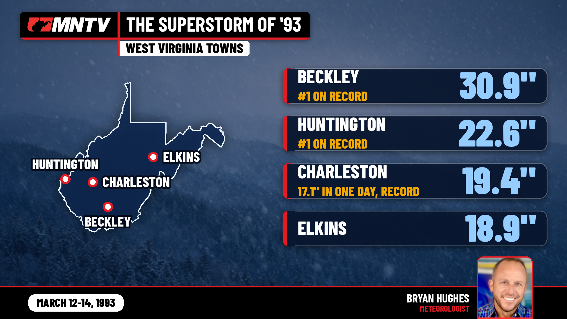 The Storm of the Century: When West Virginia Disappeared Under Feet of Snow
I’ve been forecasting West Virginia weather for 27 years, and there’s one storm folks still bring up at the grocery store, at ballgames, and in my Facebook comments: March 12-14, 1993. You might know it as the…
-
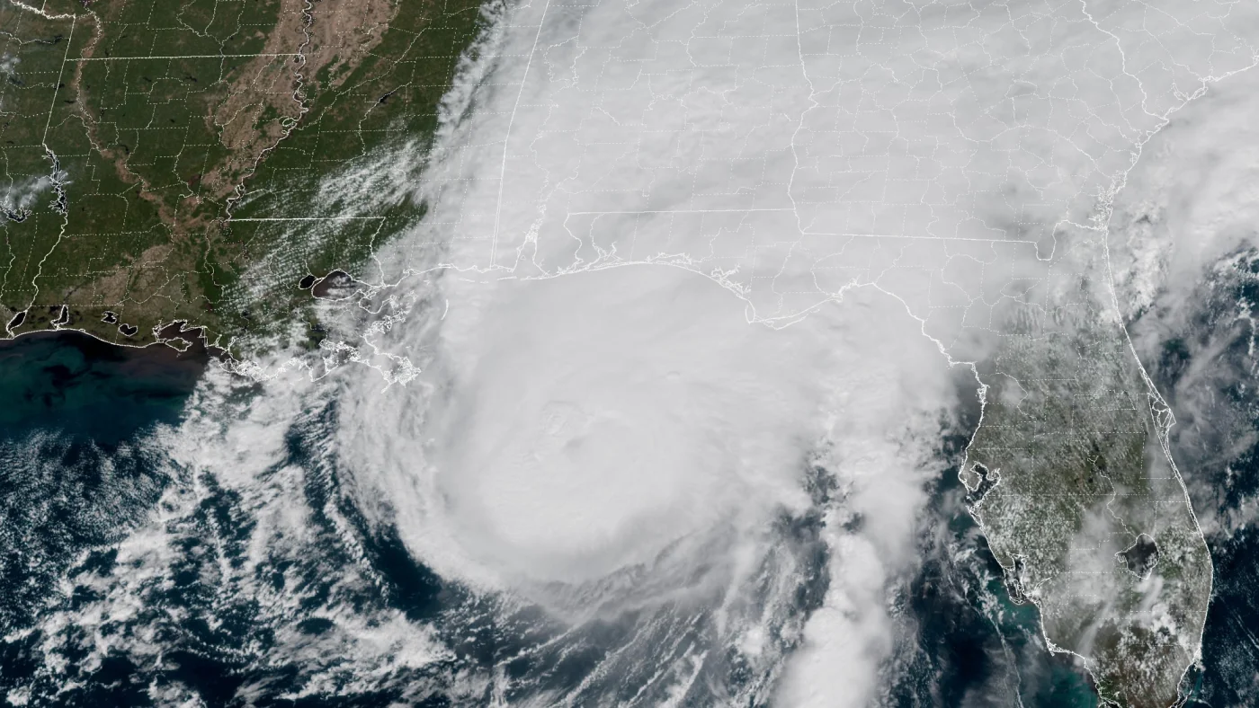 How AI is transforming hurricane forecasts
A satellite image provided by the National Oceanic and Atmospheric Administration (NOAA) shows Hurricane Isaias approaching the Gulf Coast of Alabama and Florida on Friday, Oct. 9 2026. NOAA/NOAA hide caption Hurricane…
-
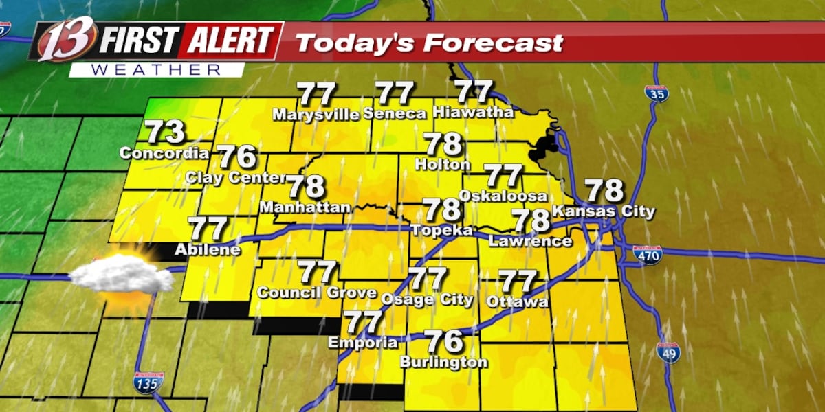 Monday forecast: Staying mild
TOPEKA, Kan. (WIBW) - The unseasonably warm weather continues all week with several opportunities for rain. The chance of rain remain low overall to begin the week with most of the rain staying in north-central KS today…
- Warmth Continues With Scattered Rain Chances, Better Odds Late Week
TOPEKA, Kan. (WIBW) - Above-normal temperatures continue through the forecast, so enjoy the warm stretch! Low rain chances move into north-central Kansas tonight into Monday, spreading east Tuesday, with greater chances…
-
 Seasonable temperatures for October's final weekend
RICHMOND, Va. -- Sunshine will mix with more clouds this afternoon, especially east and south of Richmond. Highs will be in the low to mid 60s in most areas, with some upper 60s to the southwest. Minor coastal flooding…
- Dry and Warm Through Sunday, Low-End Rain Chances Continue Through Thursday
TOPEKA, Kan. (WIBW) - A quiet, warm weekend is ahead, before low-end chances continue off and on through Thursday, but most of the area stays dry. - Low-End Rain Chances Continue Through Thursday: Low-end chances for…
-
 Drought advisory in Hampton Roads escalates
Southeast Virginia, including Hampton Roads, has moved from a drought watch to a warning as of Thursday, according to the Virginia Department of Environmental Quality. This escalation was recommended by the Drought…
-
 VDOT lists Fredericksburg District lane closures for Oct. 25–31
VDOT listed scheduled lane closures for road work in the Fredericksburg District for Oct. 25–31, weather permitting, the agency said. On I-95, mobile single lane closures to clean and wash bridges run Monday–Friday, 7…
-
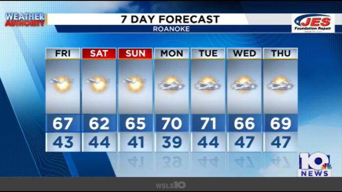 Here’s what is bringing a a mini cool down this weekend
Keep layering up this weekend- morning lows range from the upper 30s to the low 40s. Saturday and Sunday highs will trend cooler. Instead of highs in the 70s, Roanoke will warm to the low-to-mid 60s. This is as cool air…
Air quality
Air quality is satisfactory, and air pollution poses little or no risk.
Forecast
- MonGood (33)
- TueModerate (53)
Hampton Roads, VA reporting area · 1 hr ago. Data from AirNow (EPA and its state, local and tribal partners); preliminary and subject to change.
Sun & moon
Almanac
MonthlyNorfolk Area, records since 1874. Normals 1991–2020. Data from NOAA's Regional Climate Centers (ACIS).
Nearby
- Virginia Beach 43 km
- Norfolk 20 km
- Chesapeake 23 km
- East Hampton 11 km
- Hampton 9 km
- Portsmouth Heights 19 km
- Portsmouth 20 km
- Suffolk 31 km
- South Suffolk 33 km
- Williamsburg 41 km
- Poquoson 17 km
- Gloucester Point 31 km
Forecasters' discussion
From the National Weather Service office in AKQ, issued 2 hrs ago
What Has Changed
- No significant changes/Updated discussions
Key Messages
1) Remaining dry through the week. Above normal (but still seasonable) temperatures prevail through the end of the week into next weekend.
Discussion
As of 145 PM EDT Monday...
KEY MESSAGE 1...Remaining dry through the week, with temperatures running near to just above normal through the end of the week into next weekend.
The latest WX analysis indicates an amplified upper pattern, with deep upper troughing digging across the west coast, an upper-level ridge in place from the west-central Gulf coast to the Great Lakes and an upper trough sliding offshore. At the surface, ~1030 mb high pressure is centered just west of the local area, bringing seasonably mild temperatures and light/variable winds.
Not quite as cool tonight, though efficient decoupling under a weak pressure gradient will still support some upper 30s in the normally colder spots of rural south-central VA. Lows will range mainly in the upper 30s to lower 40s inland, and mid to upper 40s along the coast. Some patchy fog possible late tonight over south central VA/interior NE NC.
A weak, dry front is forecast to drop south through the area tomorrow, veering winds to the N-NE with a modest speed increase along the coast. High pressure becomes centered north of the local area Tuesday night through Wednesday, maintaining near- normal temperatures. The high then anchors off the southern New England to Mid-Atlantic coast Wednesday night and Thursday while low pressure remains suppressed well south near the Bahamas. With the high offshore, SSW winds trend highs above normal late in the week, with highs warming well into the 70s Fri/Sat.
Remaining dry into the weekend, as upper ridging builds over the region. A northern stream shortwave traversing central Canada will flatten the upper pattern Friday into the weekend. Halloween looks dry, pleasant, and mild across the region, though some increasing clouds will be possible ahead of a weak cold front, and a more unsettled pattern which is looming for the first half of next week. Trends from 12z/26 probabilistic models do show increasing potential for light rain as early as late Sunday into Monday, more likely on Monday. However, this progressive regime (at least at first) is unlikely to deliver any substantial drought-busting rain through early November, with both GEFS and EPS showing a very low probability for 24-hr QPF AOA 0.50" through at least early next week. Climatologically, despite ongoing precipitation deficits across much of the area, and even with no rain prospects on the horizon through Halloween, none of our climate sites will rank among the top 10 driest Octobers on record, owing to several past Octobers with monthly rainfall below 0.50".
Aviation
As of 145 PM EDT Monday...
Mainly SKC/VFR across area terminals this afternoon on light W-NW winds inland RIC and SBY, and N/NE along the coast at PHF, ORF, and ECG. Remaining mainly clear tonight/early Tuesday, though some patchy fog again possible mainly across interior southern VA and NE NC.
Outlook: High pressure builds north of the region Tue, and settles off to our NE Wed. N-NE winds Tue will become elevated near the coast at 10-15 kt (generally less than 10 kt inland). Winds shift to the E at 5-10 kt Wed. Other than some potential for patchy AM fog, dry WX and VFR conditions continue through late in the week.
Forecasts, observations and alerts in the United States come from the National Weather Service (NOAA); radar from NOAA's Multi-Radar Multi-Sensor system; satellite imagery from NASA's Global Imagery Browse Services (GIBS) and NOAA's GOES satellites; the map from the U.S. Geological Survey's National Map; air quality from AirNow (EPA and its partners); hurricane information from the National Hurricane Center; climate normals and records from NOAA's Regional Climate Centers (ACIS). Forecasts outside the United States and the UV index: MET Norway (CC BY 4.0); observations outside the U.S.: airport reports via NOAA's Aviation Weather Center. Place names: GeoNames (CC BY 4.0). Data are copied on a schedule and may lag the sources; for warnings that affect your safety, follow your local National Weather Service office and emergency officials. Weather news is drawn from the 4Search index and reflects what the press published. Terms of use. How to use Weather