Install
Webster, SD Weather
Current conditions
Observed at Watertown, Watertown Municipal Airport · 1 hr ago
Forecast
10-day-
Today
Sunny, with a high near 69. South wind 9 to 14 mph, with gusts as high as 25 mph.
-
Tonight
Mostly clear, with a low around 46. South wind 3 to 9 mph.
-
Wednesday
Sunny, with a high near 69. East northeast wind 2 to 7 mph.
National Weather Service forecast updated 1 hr ago.
Hourly
Hourly forecast- Now45°
- 9 AM48°
- 10 AM52°
- 11 AM56°
- 12 PM60°
- 1 PM64°
- 2 PM67°
- 3 PM68°
- 4 PM69°
- 5 PM68°
- 6 PM65°
- 7 PM62°
- 8 PM57°
- 9 PM55°
- 10 PM54°
- 11 PM54°
- Wed12 AM52°
- 1 AM51°
- 2 AM51°
- 3 AM50°
- 4 AM49°
- 5 AM47°
- 6 AM47°
- 7 AM47°
Daily forecast
Details- TodayOct 20Sunny46°69°
- WedOct 21Sunny47°69°
- ThuOct 22Sunny16%55°72°
- FriOct 23Chance Light Rain34%54°70°
- SatOct 24Chance Light Rain25%41°61°
- SunOct 25Slight Chance Light Rain15%35°54°
- MonOct 26Slight Chance Light Rain17%35°51°
- TueOct 27Cloudy37°44°
- WedOct 28Partly cloudy38°55°
Days after the National Weather Service's seven are MET Norway's outlook, a computer model with no forecaster's review.
Radar
Full mapWeather news near Webster
More weather news-
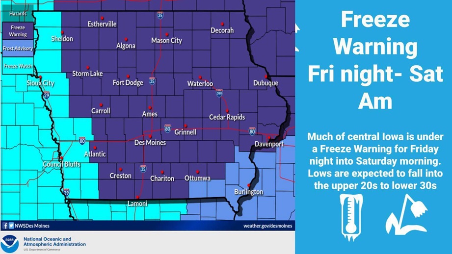 First wide freeze of the season, Iowans need to cover garden plants
by Radio Iowa Contributor | Oct 16, 2026 Iowans who have flowers and other outdoor plants they’d like to enjoy a little longer will need to cover them later today as a Freeze Warning is posted for 80 Iowa counties for…
-
 Weather Service Issues Rochester Storm Warning October 16
Severe thunderstorms threatened Rochester and four surrounding counties in western New York on Friday morning, October 16, 2026, prompting the National Weather Service to issue a warning for potentially damaging winds…
- South Dakota Winter Weather: Sioux Falls Snow Near Nov. 6?
Sioux Falls, SD – South Dakota residents wondering when the first measurable snowfall of the 2026 winter season might arrive have an early November date to watch. Sioux Falls typically records its first accumulating…
-
 Freeze Warning Issued for Parts of South Dakota and Minnesota
Forecasters say sub‑freezing temperatures could dip to around 30 degrees, bringing the first significant freeze of the season to the region. Areas in the warning in South Dakota include Codington, Deuel, Grant, and…
-
 Freeze Watch Posted for Eastern South Dakota
Go Watertown Radio SIOUX FALLS, S.D.–Low temperatures are forecasted to fall down to near to just below freezing near and east of the James River early Saturday morning. These freezing temperatures could be hazardous to…
-
 South Dakota Declares October 28 Winter Weather Preparedness Day
Like it or not, it's coming. According to the calendar, winter doesn't officially arrive until December 21st, but we know better around here. To get ready for everything winter can throw at us, the National Weather…
-
 NOAA: El Niño Likely to Bring Warmer-Than-Average Winter to South Dakota
Northeast Radio SD News – Watertown, SD - The National Weather Service says the Northern Plains should prepare for a warmer‑than‑average winter, as strong El Niño conditions are expected to influence temperatures and…
-
 South Dakota PUC Encourages Consumers to Prepare for the Season Ahead on Winter Weather Preparedness Day
“The best time to prepare for severe weather is before it becomes an emergency. Simple steps like preparing an at-home emergency kit, reviewing generator safety guidelines, and ensuring you have a carbon monoxide…
-
 South Dakota PUC Encouraging Winter Weather Preparedness
Go Watertown Radio PIERRE, S.D.–The National Weather Service has selected October 28th as Winter Weather Preparedness Day in South Dakota. Public Utilities Commissioners (PUC) encourage South Dakotans to use the day as…
-
 Dangerous Freeze Warnings Issued for North and South Dakota as Temperatures Plummet
Freeze Warnings take effect overnight across North Dakota and northern South Dakota, with lows as low as 28 degrees in Bismarck, Minot and Williston, likely ending the growing season for many areas. The warnings run…
Air quality
Acceptable. Unusually sensitive people should consider limiting prolonged outdoor exertion.
Watertown, SD reporting area · 39 min ago. Data from AirNow (EPA and its state, local and tribal partners); preliminary and subject to change.
Sun & moon
Almanac
MonthlyWebster, records since 1893. Normals 1991–2020. Data from NOAA's Regional Climate Centers (ACIS).
Nearby
Forecasters' discussion
From the National Weather Service office in ABR, issued 7 hrs ago
Key Messages
- Temperatures today and Wednesday will be 10-20 degrees warmer than normal, with highs in the upper 60s to mid 70s. Then there is the potential for temperatures to be 15-25 degrees above normal Thursday and Friday.
- Dry conditions continue through Thursday with rain chances (30- 50%) potentially returning Friday night into Saturday. Low confidence in exact track and of the system along with estimated rainfall amounts at this time.
Discussion
Issued at 122 AM CDT Tue Oct 20 2026
An upper-level ridge has moved over SD and it will stick around over the areas through Thursday. It is helping to support southerly winds moving warm temperatures into central and northeastern SD. Temperatures will be between 10-20 degrees warmer than normal today and Wednesday, with highs in the upper 60s to mid 70s. There is a small shortwave aloft that will move along the contours of the ridge. This will push a weak low pressure and front through central and northeastern SD tonight and Wednesday morning. Luckily, there is drier air over SD, which will stop the front from developing precipitation. The only thing one would notice from the front moving through will be a change in the wind direction. As dry air sticks around today and on Wednesday, there will be sunny to mostly sunny skies.
Things will start to change Thursday, as an upper-level trough helps to push a surface low pressure from NV to the northeast over MT and then Saskatchewan. While this low pressure will not move over SD, it will have a couple of fronts that move over the state. Additionally, it will cause the pressure gradient to tighten over SD as the low pressure interacts with a strong high pressure over the Great Lakes. This tight pressure gradient will start to strengthen the winds aloft that will then mix down to the surface, causing strong southerly wind gusts to occur. The strongest of these wind gusts will occur Friday afternoon through Saturday morning. Ensembles show that there is a 30-50% chance for the winds to gust up to and over than 45 mph. These winds will need to be watched in upcoming model runs to see if a wind headline might be needed. These southerly winds will help to push more warm air into SD, which will increase the temperatures. The temperatures will be 15-25 degrees warmer than normal Thursday and Friday, with highs getting up into the 70s to low 80s. The warmest temperatures will be over south central SD, with a 40-60% chance that they get over 80 degrees.
The winds are not the only thing that will need to be watched in upcoming model runs. While this low pressure system will bring our next chance for rain, the models still vary the timing, track, and amounts. The models agree that the warm front for this low will be moving over SD Thursday and stay over the state into Friday. The models vary when and where rain and potentially storms start to develop along this front and how quickly the front (and its rain) moves out. The models then vary when the cold front moves in, when the rain might develop along it, as well as how long the front and rain stays over portions of northeastern SD Saturday into Sunday. There is still a 30-50% chance of precipitation occurring a some point Friday and at sometime on Saturday, there is just lower confidence on when and where.
Aviation
Issued at 1221 AM CDT Tue Oct 20 2026
Terminals KABR,KATY,KPIR,KMBG
Good VFR conditions are forecast throughout the TAF valid period.
Abr Watches
SD...None. MN...None.
Forecasts, observations and alerts in the United States come from the National Weather Service (NOAA); radar from NOAA's Multi-Radar Multi-Sensor system; satellite imagery from NASA's Global Imagery Browse Services (GIBS) and NOAA's GOES satellites; the map from the U.S. Geological Survey's National Map; air quality from AirNow (EPA and its partners); hurricane information from the National Hurricane Center; climate normals and records from NOAA's Regional Climate Centers (ACIS). Forecasts outside the United States and the UV index: MET Norway (CC BY 4.0); observations outside the U.S.: airport reports via NOAA's Aviation Weather Center. Place names: GeoNames (CC BY 4.0). Data are copied on a schedule and may lag the sources; for warnings that affect your safety, follow your local National Weather Service office and emergency officials. Weather news is drawn from the 4Search index and reflects what the press published. Terms of use.