Install
Beaverton, OR Weather
Current conditions
Observed at Pearson Airfield · 29 min ago
Forecast
10-day-
Tonight
Mostly cloudy. Low around 47, with temperatures rising to around 49 overnight. North northwest wind around 3 mph.
-
Tuesday
Sunny. High near 75, with temperatures falling to around 73 in the afternoon. North northeast wind around 5 mph.
-
Tuesday Night
Partly cloudy. Low around 47, with temperatures rising to around 49 overnight. North northeast wind around 3 mph.
National Weather Service forecast updated 1 hr ago.
Hourly
Hourly forecast- Now52°
- 1 AM52°
- 2 AM51°
- 3 AM49°
- 4 AM49°
- 5 AM49°
- 6 AM48°
- 7 AM49°
- 8 AM49°
- 9 AM51°
- 10 AM57°
- 11 AM61°
- 12 PM65°
- 1 PM69°
- 2 PM72°
- 3 PM73°
- 4 PM74°
- 5 PM73°
- 6 PM70°
- 7 PM67°
- 8 PM61°
- 9 PM59°
- 10 PM57°
- 11 PM55°
10-day forecast
Details- TonightOct 19Mostly Cloudy47°
- TodayOct 20Sunny47°75°
- WedOct 21Sunny47°75°
- ThuOct 22Mostly Sunny42°66°
- FriOct 23Patchy Fog then Mostly Sunny40°62°
- SatOct 24Chance Light Rain54%42°59°
- SunOct 25Chance Light Rain40%42°61°
- MonOct 26Partly Sunny then Slight Chance Light Rain21%62°
- TueOct 27Light rain0.06 in47°64°
- WedOct 28Sunny50°67°
Days after the National Weather Service's seven are MET Norway's outlook, a computer model with no forecaster's review.
Radar
Full mapWeather news in Oregon
More weather news-
 Nearly 90% of Oregon is in drought as rain year begins
PORTLAND, Ore. (KATU) — Rain has started trickling into the Pacific Northwest for the season. October 1 marks the beginning of the new rain year, and in Portland, we’ve seen about 0.1” so far through the month, which is…
-
 Southern Oregon Opens the Week in Sunshine as Cooler Nights and Rain Chances Follow
Cooler air will lower Medford’s high to about 66 and Klamath Falls to 61. Grants Pass is forecast near 73, Roseburg near 64 and Brookings near 59. Clouds will be more prominent across the region, with isolated showers…
-
 Central Oregon will see mixed sun and clouds through Monday
BEND, Ore. — Central Oregon will see a mix of clouds and sunshine Sunday, with afternoon temperatures reaching the low 60s, followed by another mostly cloudy and mild day Monday. For Bend, the National Weather Service…
-
 Pleasant weather is on the way this week with a slow warmup for Eastern Washington and Northern Oregon
Nonstop Local News High pressure is building over the Pacific Northwest through the rest of the week, keeping skies mostly sunny with daytime highs in the mid to low 70s and overnight lows in the upper 30s and low 40s…
-
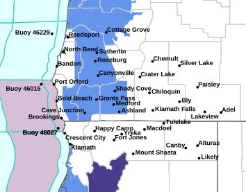 FROST ADVISORY FOR WIDE AREA OF SOUTHERN OREGON
October 13, 2026 4:00 a.m. A Frost Advisory is in effect for a wide area of southern Oregon through 9:00 a.m. Tuesday. Forecasters at the National Weather Service in Medford said temperatures as low as 33 degrees will…
Air quality
Air quality is satisfactory, and air pollution poses little or no risk.
Beaverton, OR reporting area · 1 hr ago. Data from AirNow (EPA and its state, local and tribal partners); preliminary and subject to change.
Sun & moon
Nearby
- Portland 11 km
- Vancouver 20 km
- Gresham 29 km
- Hillsboro 15 km
- Tigard 7 km
- Aloha 5 km
- Lake Oswego 13 km
- Keizer 58 km
- Oregon City 21 km
- McMinnville 44 km
- Tualatin 12 km
- West Linn 20 km
Forecasters' discussion
From the National Weather Service office in PQR, issued 2 hrs ago
Synopsis
Largely dry weather expected through midweek. Near normal temperatures today will warm above average Tuesday and Wednesday. Chances for wetter and cooler weather return late in the week with potential for a more robust system next weekend.
Discussion
Now through Sunday...An upper-level trough over the Northeast Pacific is taking on an elongated appearance in satellite imagery as it begins to cutoff from the mean flow. The developing upper low is centered near 44.5N/131.5W as of midday Monday, or just over 350 miles west of Newport, and is expected to track south off the California coast through tonight. A narrow band of clouds within a deformation zone on the eastern flank of the trough is continuing to produce modest radar returns east of the Cascade crest, however observations of rain reaching the surface have been few and far between. As this feature pivots west, there are low chances, 10-20%, of light rain in the Linn and Lane County Cascades through this evening.
Otherwise, dry conditions are expected through at least Thursday. Upper-level ridging developing over top of the closed low will support offshore flow, although the magnitude of the pressure gradient should not be enough to yield impactful winds. Nonetheless, typically windy spots in the western Columbia Gorge and near exposed ridges in the Cascades will likely see period of breezy east winds, especially overnight and in the early morning. This offshore flow will also support temperatures reaching around 10 degrees above normal Tuesday and Wednesday, translating to afternoon highs in the 60s on the coast and in terrain, and in the low to mid 70s within inland valleys.
There continues to be good consensus that progressive troughing will return to the region Thursday into Friday, while the upper low also moves inland over California supporting moisture transport about its eastern flank and into Central Oregon. This combination will support modest precipitation chances as high as 25-50% in the Lane and Linn County Cascades, but more widespread chances of 10-15%. Where rain does fall, it will likely be very light and fail to amount to significant accumulations. The approaching trough will also restore onshore flow and see temperatures fall back to more seasonable values from Thursday through the weekend.
Uncertainty in the forecast increases this weekend as long-range guidance remains mixed on the evolution of yet another trough over the Gulf of Alaska. Most ensemble members depict an occluding surface low approaching the coast somewhere between Florence and Cape Flattery at the northwestern tip of the Olympic Peninsula, with some then bringing the system inland while others see it fill and retrograde over the waters off Washington state. The intensity of this low also remains in question, with a low to moderate chance of deepening to around 990 hPa or lower. Impacts from this system may be two-fold: there is potential for widespread rainfall and strong winds cannot be ruled out. In terms of rainfall, eastward moisture transport on the southern flank of the low could amount to the first atmospheric river of the season, however the duration of the moisture flux as well as the moisture flux magnitude do not at this point appear sufficient to yield precipitation totals which would raise flooding concerns as area rivers remain near annual minimum streamflow thanks to a largely dry October thus far. If the surface low becomes deep enough and approaches near enough to the coast, coastal communities may experience strong winds. At this point, the chances for peak wind gusts of 40 mph or higher at the coast on Saturday are 15-25%.
Aviation
Through 06Z Wednesday...At 05z Tue, satellite imagery indicates a band of BKN to OVC mid to high level clouds along and east of Interstate 5 due to a low pressure system dropping southward well offshore. This cloud cover will become more widespread across NW OR and SW WA over the next few hours, then will become more scattered after 12-15z Tue as the low pressure system continues moving east. These high clouds should prevent fog and low stratus development Tuesday morning. Confidence is high (>90% chance) for predominantly VFR flight conditions through the TAF period. Winds will remain light tonight less than 5-10 kt at most terminals, though developing offshore flow and easterly winds over the Cascades will cause an increase in winds through the western Columbia River Gorge with gusts up to 25 kts. Offshore flow continues to increase after 15-18Z Tuesday, bringing increasing easterly winds to KTTD and Portland metro terminals and increasing northeast winds to KUAO. Winds will increase out of the north from KSLE to KEUG. Strongest winds will be at KTTD and east into the Gorge with gusts up to 25 kts at KTTD and up to 30-35 kts through the western Gorge. Elsewhere, winds will be lighter up to 8-10 mph.
KPDX AND APPROACHES...VFR flights conditions will continue through the TAF period with BKN high clouds tonight, scattering after 12-15z Tue. Northwest winds around 5 kt into Tuesday morning. Easterly winds are expected to develop at KPDX around 18-20Z Tuesday, sustained around 8-11 kt with occasional gusts up to 22 kts. Winds begin decreasing after 00-02z Wed. -03
Marine
A low pressure system dropping southward well offshore will generate a stronger westerly swell arriving this evening which will push seas to near 10 ft, highest beyond 10-20 NM offshore where a Small Craft Advisory is in effect starting at 5 PM today.
Winds turn northerly after sunset today and increase noticeably tonight in the wake of the passing system. Widespread wind gusts up to 25 kt will be possible over the outer waters beyond 10 nm offshore late tonight into tomorrow afternoon. Although wave heights will be on the decrease tomorrow, the increase in wind speeds will maintain hazardous conditions for small craft. Therefore, the Small Craft Advisory in effect for the outer waters beginning at 5 PM today will remain in effect through 5 PM tomorrow. Beyond 5 PM tomorrow, winds and seas will be on the decrease as high pressure returns.
Winds and seas are set to increase again Thursday into Friday morning with the passage of a weak cold front, especially over the northern waters to the north of Cape Falcon where conditions will likely be hazardous to small craft. There is the potential for a stronger low pressure system over the upcoming weekend, bringing a 20-40% chance for gale force wind gusts and seas over 10 feet. Overall confidence in the exact track and strength of this potential low pressure system is low at this time, and the forecast is worth monitoring over the next several days. -23
Forecasts, observations and alerts in the United States come from the National Weather Service (NOAA); radar from NOAA's Multi-Radar Multi-Sensor system; satellite imagery from NASA's Global Imagery Browse Services (GIBS) and NOAA's GOES satellites; the map from the U.S. Geological Survey's National Map; air quality from AirNow (EPA and its partners); hurricane information from the National Hurricane Center; climate normals and records from NOAA's Regional Climate Centers (ACIS). Forecasts outside the United States and the UV index: MET Norway (CC BY 4.0); observations outside the U.S.: airport reports via NOAA's Aviation Weather Center. Place names: GeoNames (CC BY 4.0). Data are copied on a schedule and may lag the sources; for warnings that affect your safety, follow your local National Weather Service office and emergency officials. Weather news is drawn from the 4Search index and reflects what the press published. Terms of use.