Install
Holly Springs, MS Weather
Current conditions
Observed at Memphis International Airport · 37 min ago
Forecast
10-day-
Tonight
Partly cloudy, with a low around 49. East southeast wind 0 to 5 mph.
-
Monday
Partly sunny, with a high near 75. Southeast wind around 5 mph.
-
Monday Night
Patchy fog after 2am. Partly cloudy, with a low around 49. East southeast wind around 0 mph.
National Weather Service forecast updated 8 hrs ago.
Hourly
Hourly forecast- Now55°
- Mon12 AM54°
- 1 AM53°
- 2 AM52°
- 3 AM52°
- 4 AM51°
- 5 AM50°
- 6 AM49°
- 7 AM49°
- 8 AM50°
- 9 AM56°
- 10 AM64°
- 11 AM68°
- 12 PM70°
- 1 PM72°
- 2 PM73°
- 3 PM74°
- 4 PM75°
- 5 PM73°
- 6 PM71°
- 7 PM66°
- 8 PM60°
- 9 PM57°
- 10 PM56°
10-day forecast
Details- TodayOct 25Mostly Sunny49°77°
- MonOct 26Partly Sunny49°75°
- TueOct 27Areas Of Fog then Partly Sunny50°76°
- WedOct 28Mostly Sunny50°77°
- ThuOct 29Sunny52°79°
- FriOct 30Mostly Sunny17%59°78°
- SatOct 31Chance Rain Showers78%62°78°
- SunNov 1Rain0.30 in64°73°
- MonNov 2Cloudy60°74°
- TueNov 3Sunny56°75°
Days after the National Weather Service's seven are MET Norway's outlook, a computer model with no forecaster's review.
Radar
Full mapWeather news in Mississippi
More weather news- Precipitation in the first 30 days of fall was extreme in many parts of the US. The Northwestern US and lower Mississippi River were parched, while the Southwest, South Plains and Southeast got much above normal precipitation. — Denise Gutzmer
Visit the post for more. Leave a Reply Cancel reply Discover more from Coyote Gulch
-
 Dry and breezy conditions lead to fire concerns across South Mississippi
Tonight stays mostly clear with a lows dropping to the low and mid 50s inland, while we sit a little closer to the upper 50s at the coast. We won’t see many changes over the weekend as Saturday is looking sunny again…
-
 Cool jackets Thursday morning, T-shirts by lunch! Perfect fall day ahead in South Mississippi
WLOX If you’re heading out the door Thursday morning, take a light jacket! Temps are running from the 40s and 50s inland to right around 60 on the coast. It’s that crisp, fall feel to start the day. Now, the bigger…
-
 The fall-like feel continues for South Mississippi
It’s already feeling a little cool tonight, and even more so by morning as temperatures fall back to the upper 40s and low 50s. Expect plenty of sunshine over the next several days, with afternoon highs mostly in the…
-
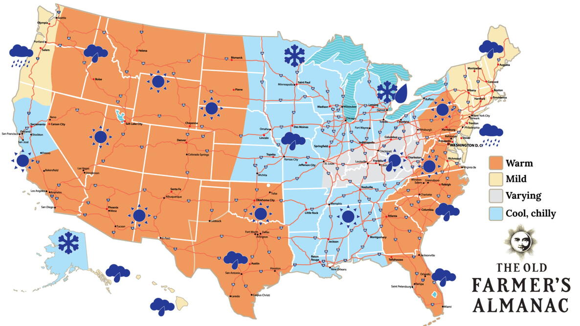 Old Farmer’s Almanac predicts Thanksgiving weather in Mississippi
The Old Farmer’s Almanac has released its weather forecast for Thanksgiving 2026, predicting a mix of sunshine, rain, and snow across the country. But what does the forecast have in store for Mississippi? According to…
-
 Your Mississippi forecast for Tuesday, October 20
Tuesday will be sunny and dry, and there's an elevated risk of fires across Mississippi. According to the Mississippi Forestry Commission, over 30 counties Tuesday will be sunny and dry, and there’s an elevated risk of…
-
 Clear nights and sunny skies on tap for south Mississippi
We are in for a beautiful stretch of fall weather this week, with plenty of sunshine and comfortable temperatures expected through early next week. Tuesday through Friday will bring sunny skies and highs near 80…
- Lunch-hour check: That chilly start is gone — gorgeous mid-70s afternoon ahead in South Mississippi
Perfect weather to eat outside, walk the beach — and you’ll need the jacket again Tuesday morning Well, that chilly morning is behind us, South Mississippi! Hope you grabbed the jacket earlier. If you’re stepping out…
Air quality
Air quality is satisfactory, and air pollution poses little or no risk.
Forecast
- SunModerate (51)
- MonGood (50)
- TueModerate
Hernando, MS reporting area · 1 hr ago. Data from AirNow (EPA and its state, local and tribal partners); preliminary and subject to change.
Sun & moon
Almanac
MonthlyHolly Springs 4 N, records since 2008. Normals 1991–2020. Data from NOAA's Regional Climate Centers (ACIS).
Nearby
- Cordova 52 km
- Southaven 57 km
- Collierville 36 km
- Germantown 48 km
- Olive Branch 41 km
- Horn Lake 57 km
- Oxford 45 km
- Hernando 50 km
- Lakeland 58 km
- New Albany 51 km
- Senatobia 50 km
- Oakland 52 km
Forecasters' discussion
From the National Weather Service office in MEG, issued 1 hr ago
Key Messages
Issued at 1029 PM CDT Sun Oct 25 2026
- Dry conditions and above-normal temperatures will persist across the Mid-South through the work week.
- Elevated fire weather conditions will continue into midweek due to warm temperatures, low relative humidity, and dry vegetation.
- Precipitation chances begin to increase this weekend as a slight pattern change occurs.
Discussion
(Tonight through next Sunday) Issued at 1029 PM CDT Sun Oct 25 2026
Rinse and repeat. Above normal temperatures and dry conditions will persist as an anomalous 592dam ridge remains parked over the central CONUS. Chilly mornings with lows in the 40s to mid 50s and warm afternoons with highs in the mid 70s to lower 80s will remain the story. A very dry airmass also remains fixed over the Mississippi Valley with a very dry air column present as PWATs remain around the 25th percentile for this time of the year, 0.5- 0.7". It goes without saying, this airmass will not be able to sustain any precipitation over the next several days. Through midweek, very efficient diurnal mixing will result in afternoon dewpoints in the 40s. A combination of low relative humidity, dry fuels, and warm temperatures will result in elevated fire weather concerns through this period.
By midweek, upper-level southwest flow will begin to build across the region. In terms of precipitation and temperatures, little to no change is to note as we remain dry and above normal. As persistent ridging flattens, dewpoints may be able to surge ever so slightly Wednesday through the end of the workweek, however, fire weather concerns will continue given dry vegetation and worsening drought conditions. To answer the question, when will we see rain next, late Friday, a subtropical jet will begin to strengthen over the Southern Plains. This will finally promote an end to our persistent dry spell as moisture begins to increase over the Middle Mississippi Valley this weekend. Latest LREF guidance has a 40% chance of exceeding 0.5" of precipitation and a 50-60% chance of exceeding 0.25". Bottom line, we're not looking at a washout, but we'll take what we can get with extreme drought (D3) and exceptional drought (D4) over portions of the Mid-South.
AEH
Aviation
(00Z TAFS) Issued at 633 PM CDT Sun Oct 25 2026
VFR will prevail at all four terminals through the period. Expect light east-southeasterly winds with an increase in upper level cloud cover.
Fire Weather
Issued at 1029 PM CDT Sun Oct 25 2026
Elevated fire weather concerns will persist through at least midweek. The latest Energy Release Component is forecast to remain above the 90th percentile through Tuesday. This, combined with dry fuels and minimum relative humidity around 30 percent, will promote increased fire starts and growth. The main limiting factor for high fire danger will be 20 ft winds, which are forecast to remain below 10 mph. A Rangeland Fire Danger Statement has been issued for Monday and additional Statements are anticipated through midweek. Otherwise, expect each day to feature dry conditions with isolated patchy fog in low-lying areas.
Forecasts, observations and alerts in the United States come from the National Weather Service (NOAA); radar from NOAA's Multi-Radar Multi-Sensor system; satellite imagery from NASA's Global Imagery Browse Services (GIBS) and NOAA's GOES satellites; the map from the U.S. Geological Survey's National Map; air quality from AirNow (EPA and its partners); hurricane information from the National Hurricane Center; climate normals and records from NOAA's Regional Climate Centers (ACIS). Forecasts outside the United States and the UV index: MET Norway (CC BY 4.0); observations outside the U.S.: airport reports via NOAA's Aviation Weather Center. Place names: GeoNames (CC BY 4.0). Data are copied on a schedule and may lag the sources; for warnings that affect your safety, follow your local National Weather Service office and emergency officials. Weather news is drawn from the 4Search index and reflects what the press published. Terms of use. How to use Weather