Install
Gulf Hills, MS Weather
Current conditions
Observed at Keesler Air Force Base / Biloxi · 1 hr ago
Forecast
10-day-
Saturday Night
Clear, with a low around 57. Northeast wind 10 to 15 mph.
-
Sunday
Sunny, with a high near 76. Northeast wind 10 to 15 mph.
-
Sunday Night
Mostly clear, with a low around 55. Northeast wind 5 to 10 mph.
National Weather Service forecast updated 2 days ago.
Hourly
Hourly forecast- Now60°
- 2 AM59°
- 3 AM59°
- 4 AM58°
- 5 AM58°
- 6 AM57°
- 7 AM57°
- 8 AM60°
- 9 AM62°
- 10 AM64°
- 11 AM67°
- 12 PM70°
- 1 PM73°
- 2 PM74°
- 3 PM75°
- 4 PM76°
- 5 PM74°
- 6 PM72°
- 7 PM69°
- 8 PM66°
- 9 PM64°
- 10 PM62°
- 11 PM60°
- Mon12 AM59°
10-day forecast
Details- ThuOct 22Sunny58°78°
- FriOct 23Sunny58°78°
- SatOct 24Sunny57°75°
- TodayOct 25Sunny55°76°
- MonOct 26Mostly Sunny56°75°
- TueOct 27Mostly Sunny56°76°
- WedOct 28Mostly Sunny56°77°
- ThuOct 29Mostly sunny59°77°
- FriOct 30Cloudy61°77°
- SatOct 31Cloudy56°73°
Days after the National Weather Service's seven are MET Norway's outlook, a computer model with no forecaster's review.
Radar
Full mapWeather news in Mississippi
More weather news-
 Dry and breezy conditions lead to fire concerns across South Mississippi
Tonight stays mostly clear with a lows dropping to the low and mid 50s inland, while we sit a little closer to the upper 50s at the coast. We won’t see many changes over the weekend as Saturday is looking sunny again…
- Precipitation in the first 30 days of fall was extreme in many parts of the US. The Northwestern US and lower Mississippi River were parched, while the Southwest, South Plains and Southeast got much above normal precipitation. — Denise Gutzmer
Visit the post for more. Leave a Reply Cancel reply Discover more from Coyote Gulch
-
 Cool jackets Thursday morning, T-shirts by lunch! Perfect fall day ahead in South Mississippi
WLOX If you’re heading out the door Thursday morning, take a light jacket! Temps are running from the 40s and 50s inland to right around 60 on the coast. It’s that crisp, fall feel to start the day. Now, the bigger…
-
 The fall-like feel continues for South Mississippi
It’s already feeling a little cool tonight, and even more so by morning as temperatures fall back to the upper 40s and low 50s. Expect plenty of sunshine over the next several days, with afternoon highs mostly in the…
-
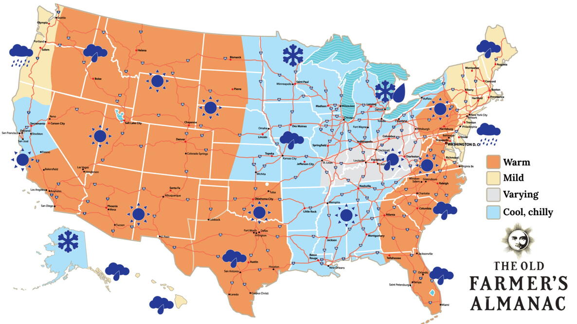 Old Farmer’s Almanac predicts Thanksgiving weather in Mississippi
The Old Farmer’s Almanac has released its weather forecast for Thanksgiving 2026, predicting a mix of sunshine, rain, and snow across the country. But what does the forecast have in store for Mississippi? According to…
-
 Your Mississippi forecast for Tuesday, October 20
Tuesday will be sunny and dry, and there's an elevated risk of fires across Mississippi. According to the Mississippi Forestry Commission, over 30 counties Tuesday will be sunny and dry, and there’s an elevated risk of…
-
 Clear nights and sunny skies on tap for south Mississippi
We are in for a beautiful stretch of fall weather this week, with plenty of sunshine and comfortable temperatures expected through early next week. Tuesday through Friday will bring sunny skies and highs near 80…
- Lunch-hour check: That chilly start is gone — gorgeous mid-70s afternoon ahead in South Mississippi
Perfect weather to eat outside, walk the beach — and you’ll need the jacket again Tuesday morning Well, that chilly morning is behind us, South Mississippi! Hope you grabbed the jacket earlier. If you’re stepping out…
Air quality
Acceptable. Unusually sensitive people should consider limiting prolonged outdoor exertion.
Forecast
- SunModerate (51)
- MonModerate
- TueModerate
Mississippi Gulf Coast, MS reporting area · 1 hr ago. Data from AirNow (EPA and its state, local and tribal partners); preliminary and subject to change.
Sun & moon
Almanac
MonthlyGulfport Area, records since 1893. Normals 1991–2020. Data from NOAA's Regional Climate Centers (ACIS).
Nearby
- Gulfport 25 km
- West Gulfport 24 km
- Biloxi 6 km
- Pascagoula 28 km
- Gautier 23 km
- Ocean Springs 3 km
- Long Beach 31 km
- Moss Point 30 km
- D'Iberville 5 km
- Bay Saint Louis 49 km
- Diamondhead 50 km
- Saint Martin 3 km
Forecasters' discussion
From the National Weather Service office in LIX, issued 52 min ago
Key Messages
Updated at 1225 AM CDT Sun Oct 25 2026
- Elevated fire danger will continue through much of the work week. The current and worsening drought conditions and dry fuels combined with low humidity and moderate winds will lead to potential for rapid fire growth. Residents should obey all burn bans in place and exercise extreme caution with any open flames outdoors even in areas that do not currently have burn bans in place.
- Strong winds will continue to result in hazardous conditions for small craft across most coastal waters of southeast Louisiana and Mississippi into at least Tuesday.
Short Term
(Now through Wednesday) Issued at 1225 AM CDT Sun Oct 25 2026
Upper ridging extended from the western Gulf to Michigan during the evening, with troughs over the western Atlantic south to Cuba, and over Utah/Arizona. At the surface, high pressure extended southwestward from Pennsylvania into south Texas. Clear skies across the area at midnight with most temperatures in the 50s.
The upper ridge will drift eastward over the next several days and be centered near Savannah Georgia on Wednesday. A weak upper low will be over the Bahamas at that time, with troughing over the eastern Pacific. At the surface, high pressure will remain pretty much where it's at right now. Precipitable water values will remain near the 25th percentile (0.75 inches).
Don't expect much in the way of clouds, let alone rain, through Wednesday. Very little day to day change in high and low temperatures. High temperatures about 5 to 10 degrees above normal, with lows 3 to 5 degrees above normal.
Long Term
(Wednesday night through Saturday) Issued at 1225 AM CDT Sun Oct 25 2026
Longer term forecast continues to look pretty quiet as stubborn high pressure dominates the southeastern CONUS. Could see some moisture return undercut the upper ridging by next weekend, but generally speaking, air mass should remain pretty dry through the period.
Diurnal ranges will continue to be fairly large with lows in the 50s and lower 60s area-wide and highs in the low to mid 80s most places.
Will be monitoring trends regarding the potential for a frontal passage in early November, though latest model runs have backed off on this solution a bit. Bottom line - doesn't look like we'll have any meaningful rain chances for at least the next week.
Aviation
(06Z TAFS) Issued at 1225 AM CDT Sun Oct 25 2026
High pressure will keep VFR conditions in place through the period. Winds generally easterly, and 10-12 knots at most at forecast terminals.
Forecasts, observations and alerts in the United States come from the National Weather Service (NOAA); radar from NOAA's Multi-Radar Multi-Sensor system; satellite imagery from NASA's Global Imagery Browse Services (GIBS) and NOAA's GOES satellites; the map from the U.S. Geological Survey's National Map; air quality from AirNow (EPA and its partners); hurricane information from the National Hurricane Center; climate normals and records from NOAA's Regional Climate Centers (ACIS). Forecasts outside the United States and the UV index: MET Norway (CC BY 4.0); observations outside the U.S.: airport reports via NOAA's Aviation Weather Center. Place names: GeoNames (CC BY 4.0). Data are copied on a schedule and may lag the sources; for warnings that affect your safety, follow your local National Weather Service office and emergency officials. Weather news is drawn from the 4Search index and reflects what the press published. Terms of use.