Install
Excelsior Springs, MO Weather
Current conditions
Observed at Kansas City, Kansas City Downtown Airport · 55 min ago
Forecast
10-day-
Sunday
Partly sunny, with a high near 78.
-
Sunday Night
Mostly cloudy, with a low around 54.
-
Monday
Partly sunny, with a high near 75.
National Weather Service forecast updated 2 days ago.
Hourly
Hourly forecast- Now78°
- 4 PM78°
- 5 PM76°
- 6 PM74°
- 7 PM71°
- 8 PM68°
- 9 PM65°
- 10 PM62°
- 11 PM60°
- Mon12 AM59°
- 1 AM58°
- 2 AM57°
- 3 AM56°
- 4 AM56°
- 5 AM55°
- 6 AM54°
- 7 AM54°
- 8 AM56°
- 9 AM59°
- 10 AM62°
- 11 AM66°
- 12 PM70°
- 1 PM72°
- 2 PM74°
10-day forecast
Details- TonightOct 22Mostly Clear51°
- FriOct 23Sunny55°78°
- SatOct 24Mostly Sunny54°78°
- TodayOct 25Partly Sunny54°78°
- MonOct 26Partly Sunny54°75°
- TueOct 27Mostly Cloudy52°71°
- WedOct 28Mostly Sunny29%53°74°
- ThuOct 29Chance Rain Showers31%69°
- FriOct 30Partly cloudy43°56°
- SatOct 31Cloudy0.13 in45°61°
Days after the National Weather Service's seven are MET Norway's outlook, a computer model with no forecaster's review.
Radar
Full mapWeather news near Excelsior Springs
More weather news-
 30 years since ‘October Surprise’ snowstorm hit Kansas City
KANSAS CITY, Mo. -- The thought of snow this October seems far away with the first part of the month still feeling like summer with temperatures reaching 90 degrees and severe weather last week. Thursday marks 30 years…
-
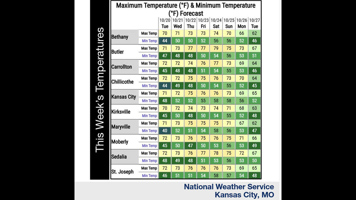 Kansas City’s warm, mostly dry stretch lasts through Sunday. What comes next?
Fall temperatures are climbing in Kansas City again Tuesday, with warmer-than-normal weather expected through the weekend, the National Weather Service says. Skies will become increasingly cloudy as metro temperatures…
-
 KSHB 41 Weather | Sunshine and highs in the 60s Sunday in Kansas City
KSHB 41 Weather | Sunshine and highs in the 60s Sunday KSHB 41 Kansas City KSHB 41 Weather | Sunshine and highs in the 60s Sunday in Kansas City KANSAS CITY, Mo. — Hosting an event or gathering? Send your weather…
-
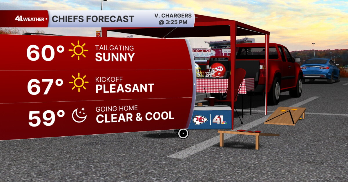 KSHB 41 Weather Blog | Pleasant stretch of weather in store for Kansas City
KANSAS CITY, Mo. — Pleasant, fall weather is sticking around for the next few days, before highs reach near 80° by the end of the week. Sunday is going to be the ideal fall day. Chilly in the morning, then reaching the…
-
 KSHB 41 Weather Blog | Freeze and frost potential Saturday morning
KANSAS CITY, Mo. — Lows are expected to drop into the 30s Saturday morning — the coldest Kansas City has been since early May. Temperatures on Friday will struggle to make it out of the low 50s. Strong, chilly winds out…
-
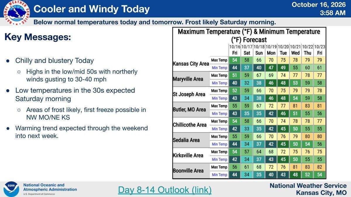 Cold night ahead: Season’s first frost likely, freeze possible in Kansas City area
A cool, cloudy and windy day is expected in the Kansas City area Friday, with frost and maybe the season’s first freeze overnight, according to the National Weather Service. Temperatures across the region will likely…
- WEATHER BLOG: Chilly temperatures for Friday night football; frost likely Saturday
Fall is in the air this weekend, and a little bit of winter's chill will sneak in as well! Strong north winds this afternoon will average 20 mph, with gusts up to 35 mph. Combined with a mostly cloudy sky, temperatures…
-
 Significantly cooler Friday, first frost possible tonight
KANSAS CITY, Mo. (KCTV) - A sharp cooldown with weekend frost will give way to a warming trend by next week. FRIDAY: Extra layers are the name of the game today! It is significantly cooler out the door for the morning…
-
 Thursday Evening Forecast: Mid-Missouri Weather Update
KRCG has released its Thursday evening forecast for the mid-Missouri viewing area covering October 22, 2026. The update details expected temperatures, cloud cover and precipitation chances for the coming hours and…
-
 Missouri farmers wait as rains stall fieldwork
A farmer in west-central Missouri says the recent rains are delaying early planting, and while the moisture is needed, it’s heavier than expected. “So far, we’ve had a little more than four inches since the start of the…
Air quality
Acceptable. Unusually sensitive people should consider limiting prolonged outdoor exertion.
Forecast
- SunModerate (51)
- MonModerate (58)
Kansas City, MO reporting area · 1 hr ago. Data from AirNow (EPA and its state, local and tribal partners); preliminary and subject to change.
Sun & moon
Almanac
MonthlySmithville Lake, records since 1985. Normals 1991–2020. Data from NOAA's Regional Climate Centers (ACIS).
Nearby
- Kansas City 40 km
- Overland Park 55 km
- Kansas City 43 km
- Independence 32 km
- Lee's Summit 49 km
- Shawnee 54 km
- Blue Springs 36 km
- Leavenworth 60 km
- Leawood 53 km
- Liberty 20 km
- Raytown 42 km
- Gladstone 32 km
Forecasters' discussion
From the National Weather Service office in EAX, issued 9 hrs ago
Key Messages
- Warm and dry through the weekend. Temperatures trend cooler by the end of next week, but remain above seasonal norms.
- Minimal precipitation chances return Tuesday through Wednesday (10- 25% chances, mainly AM); highest potential late week into next weekend (30-60% chances).
Discussion
Issued at 317 AM CDT Sun Oct 25 2026
Quiet and seasonably warm remains the name of the game today and to begin the new work week, but gradually gives way to more unsettled conditions. Especially by late week and into next weekend.
The current big picture view across CONUS continues to be highlighted by surface high pressure and mid-level ridging dominating the east and multiple mid-level troughs or cut-off lows providing active conditions over the Mountain West and Pacific Coast areas. While Central CONUS is the transition between the two regimes, the local area remains dominantly under the influence of the mid-level ridge and the westward ooze of the large surface high. For today, that means yet another rinse and repeat day for the most part with temperatures again well above seasonal norms and in the upper 70s to low 80s. Winds will be lighter than previous days given the position of the surface high, and high level cloud cover will continue to drift across the region. The work-week starts out much the same, albeit likely a couple degrees cooler as 925-850mb temps are expected to come down from around 13 deg C to 11 deg C. By Monday, the current mid-level cutoff low over the SW CONUS will have begun to drift NE through the Intermountain West and become more of an open wave. Model trends continue to push best large scale lift and thus precipitation chances W/NW of the area, yielding no mentionable PoPs through Monday evening.
By Tuesday, the aforementioned mid-level open wave will have effectively flattened and shunted the mid-level ridge eastward. This most readily allows more southwesterly flow across the region. Deterministic guidance depicts a shortwave moving through this flow and a smattering of QPF. The QPF may be a bit generous as lift is concentrated above 700mb and in an environment with lackluster lapse rates / no instability and a dry sub-cloud layer. NBM did populate with some low (<25 percent) PoPs at times Tuesday, mainly over W/NW areas of the CWA, but have left them in place as some light rain cannot be completely ruled out. Wednesday sees steeper lapse rates and some increasing low-level moisture helping yield some instability, but the lack of a lifting mechanism and cap should keep the area dry through the day. By Wednesday night, question becomes just how far southward a synoptic front is able to progress. Near/along that boundary will be the best opportunity for any precipitation, and is reflected in 25-50 percent PoPs mainly over northern areas of the CWA Wednesday evening/overnight. Thursday yields similar questions to Wednesday, with the position of the synoptic front looking to dictate where and if any precipitation will be see in the area. Prevailing sentiment among ensemble guidance keeps best chances primarily over northern half of the area. Temperatures at least partially hinge on cloud cover and precipitation chances, but prevailing ensemble solutions point to ongoing seasonably warm conditions well into the 70s.
Rounding out the work week and into the weekend, conditions become more active, at least primed for precipitation/showers. Modest low- mid level moisture return is well corroborated, along with a series of shortwaves expected to move through the SW mid-level flow. Given timing differences in shortwave arrivals, result tends to be broad/area-wide 30-60 percent PoPs moving in late Friday and through the weekend. Inevitably, it will not rain that entire time, but a wait and see as shortwave timing gets resolved in coming days. Unfortunately, this also potentially means a soggy Halloween across the area. Temperatures likely cool during this time frame as well, but uncertainty in shortwave / potential precip timing yields MaxT 25th/75th temp spreads approaching 7 to 10+ deg F.
Aviation
Issued at 608 AM CDT Sun Oct 25 2026
VFR conditions to prevail through the period. Winds will be light, largely around 4-7 kts or less. Predominant direction being out of the south to southeast. Cloud cover tends to increase through the period, but of the high level cloud deck variety.
Eax Watches
MO...None. KS...None.
Forecasts, observations and alerts in the United States come from the National Weather Service (NOAA); radar from NOAA's Multi-Radar Multi-Sensor system; satellite imagery from NASA's Global Imagery Browse Services (GIBS) and NOAA's GOES satellites; the map from the U.S. Geological Survey's National Map; air quality from AirNow (EPA and its partners); hurricane information from the National Hurricane Center; climate normals and records from NOAA's Regional Climate Centers (ACIS). Forecasts outside the United States and the UV index: MET Norway (CC BY 4.0); observations outside the U.S.: airport reports via NOAA's Aviation Weather Center. Place names: GeoNames (CC BY 4.0). Data are copied on a schedule and may lag the sources; for warnings that affect your safety, follow your local National Weather Service office and emergency officials. Weather news is drawn from the 4Search index and reflects what the press published. Terms of use. How to use Weather