Install
Saginaw Township North, MI Weather
Current conditions
Forecast for this hour (no station report in the last two hours)
Forecast
10-day-
Sunday Night
Patchy fog after 2am. Mostly cloudy, with a low around 48.
-
Monday
Patchy fog before 9am. Partly sunny, with a high near 62.
-
Monday Night
Mostly cloudy, with a low around 42.
National Weather Service forecast updated 3 days ago.
Hourly
Hourly forecast- Now49°
- 6 AM48°
- 7 AM48°
- 8 AM48°
- 9 AM50°
- 10 AM52°
- 11 AM55°
- 12 PM57°
- 1 PM59°
- 2 PM60°
- 3 PM61°
- 4 PM61°
- 5 PM61°
- 6 PM60°
- 7 PM58°
- 8 PM55°
- 9 PM53°
- 10 PM51°
- 11 PM49°
- Tue12 AM47°
- 1 AM46°
- 2 AM46°
- 3 AM45°
- 4 AM44°
10-day forecast
Details- TonightOct 22Widespread Fog43°
- FriOct 23Widespread Fog then Mostly Sunny42°65°
- SatOct 24Patchy Fog then Sunny45°67°
- SunOct 25Patchy Fog then Mostly Sunny48°71°
- TodayOct 26Patchy Fog then Partly Sunny42°62°
- TueOct 27Partly Sunny39°57°
- WedOct 28Partly Sunny19%44°62°
- ThuOct 29Slight Chance Light Rain19%64°
- FriOct 30Cloudy34°51°
- SatOct 31Sunny32°53°
Days after the National Weather Service's seven are MET Norway's outlook, a computer model with no forecaster's review.
Radar
Full mapWeather news in Michigan
More weather news-
 Severe weather possible Tuesday in Southeast Michigan. Here's the timing and what to look for.
Updated on: April 14, 2026 / 11:50 PM EDT / CBS Detroit A severe weather threat exists for Tuesday, and Southeast Michigan is squarely in the path. A potent weather system is dragging unseasonably warm, humid air into…
-
 Old Farmer’s Almanac predicts Thanksgiving weather in Michigan for 2026
The Old Farmer's Almanac released their 2026 Thanksgiving Day weather outlook. The Old Farmer’s Almanac, known for its long-range weather forecasts, has released its Thanksgiving weather outlook for 2026, and it’s…
-
 Early Halloween forecast points to mild, mostly dry weather for Michigan
With Halloween set to take place next weekend, initial forecast projections are beginning to be made for the region. While forecasts are generally inaccurate this far out, initial outlooks are showing a solid day for…
-
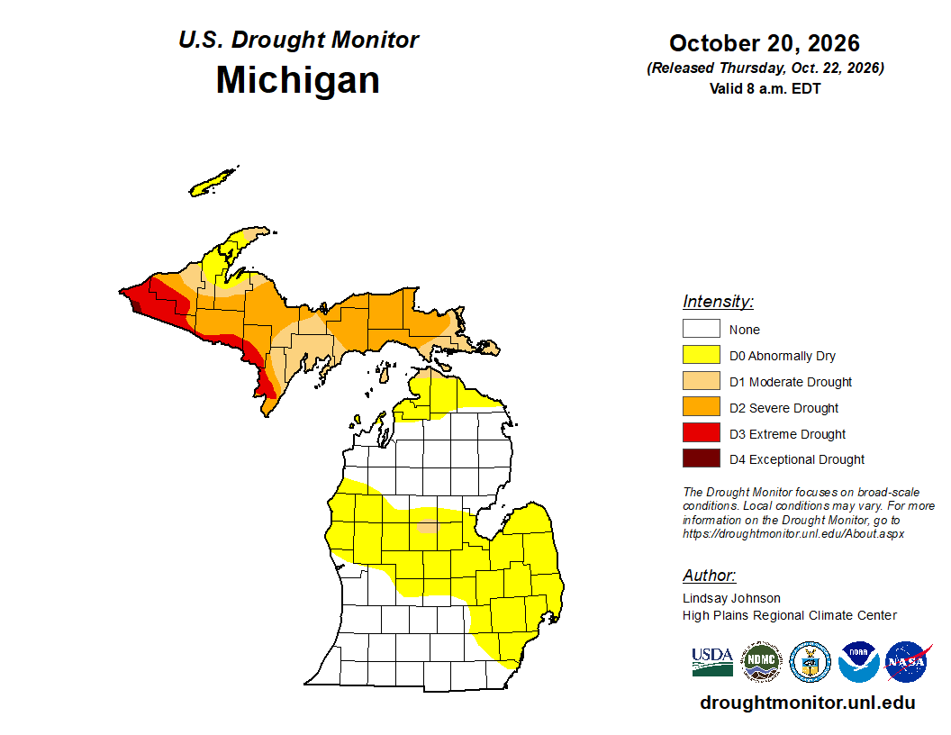 Mid-Michigan turns abnormally dry after a relatively dry October
Minor drought conditions are being observed in Mid-Michigan after a dry month. Minor drought conditions have been noted across the Mid-Michigan area as October has been notably dry. Currently, much of the Lower…
-
 Michigan's first snow: Average first snow dates by city for 2026
Most Michigan cities typically see their first snowfall between late October and mid-November. While cooler temperatures are expected to continue statewide, the question remains: When will the season’s first snowfall…
-
 Sunshine and Mild Temperatures Continue Across Southeast Michigan
ClickOnDetroit | WDIV Local 4 Trader Joe’s is expanding nationwide, including new Metro Detroit store Sunshine and Mild Temperatures Continue Across Southeast Michigan Oakland County Little League umpire shared child…
-
 How El Niño could impact the coming Michigan winter
The National Oceanic and Atmospheric Administration's seasonal weather outlook for winter 2026-27 is here, and it suggests the current El Niño could have a significant impact on Michigan. The NOAA predicts…
Air quality
Air quality is satisfactory, and air pollution poses little or no risk.
Forecast
- MonModerate
Bay Area-Thumb Area, MI reporting area · 1 hr ago. Data from AirNow (EPA and its state, local and tribal partners); preliminary and subject to change.
Sun & moon
Almanac
MonthlySaginaw Area, records since 1912. Normals 1991–2020. Data from NOAA's Regional Climate Centers (ACIS).
Nearby
- Flint 56 km
- Saginaw 6 km
- Midland 26 km
- Bay City 18 km
- Owosso 53 km
- Beecher 48 km
- Alma 54 km
- Flushing 46 km
- Saint Louis 49 km
- Freeland 12 km
- Bridgeport 15 km
- Buena Vista 10 km
Forecasters' discussion
From the National Weather Service office in DTX, issued 2 hrs ago
Key Messages
- Dry weather continues today through Thursday.
- Temperatures remain at or slightly above normal today and Tuesday, despite a shallow cold front sagging southward across the region.
- A low chance of fog or low clouds across the Thumb and Tri-Cities tonight and Tuesday morning.
- A renewed warming trend begins Wednesday and Thursday as high temperatures return to the 70s.
- The next chance for measurable rainfall holds off until Thursday night and Friday along the next weak cold front.
Discussion
A weakly forced cold front lean on moisture is the weather highlight for SE Mi today. The initial wind shift passes through the Tri Cities and northern Thumb leading up to sunrise while any remaining pockets of rain continue dissipating. The front lacks moisture and is just too far south of the Ontario mid level trough and upper jet to sustain precipitation, however clouds are plentiful along and behind the surface boundary. This helps sharpen an already respectable boundary layer temperature gradient, but which takes nearly the entire day to reach the Ohio border. The weak and slow low level cold advection allows another day of above normal high temperatures south of I-69, and especially from metro Detroit to the Ohio border where highs around 70 are once again in reach. Boundary layer cold advection then gains traction tonight as the surface front settles into the Ohio valley and high pressure slides across northern Ontario to strengthen NE flow into the central Great Lakes. Low to mid level frontal clouds linger overhead with the chance for a stratocu component inland from Lake Huron. Guidance temperatures still only drop to normal lows in the upper 30s Tri Cities and Thumb to mid 40s metro Detroit southward by sunrise.
Tuesday ends up being cooler compared to recent days, however still at or slightly above normal. Mid level clouds hold through the day within the mid levels of the frontal zone stalled overhead while the surface boundary remains located across the Ohio valley. The clouds combine with steady NE wind into Lower Mi to produce high temperatures in the mid 50s to lower 60s. Broad low pressure developing from the central Plains into central Canada then begins a new warming trend across the Midwest which spreads into the Great Lakes Wednesday. There are additional clouds but still not much sign of rain in the warm advection pattern among the 26/00Z models, however guidance temperatures quickly return to around 70 Wednesday afternoon and lower to mid 70s Thursday. Records are in the upper 70s for Thursday/29th as recently as 2024.
The larger scale upper air pattern maintains a split flow in the northern stream jet during the late week which directs surface low tracks from the SW States into central Canada and then eastward. This keeps the associated cold fronts more benign upon reaching Lower Mi with the next one projected for Thursday night into Friday. It presents the next chance of rain but not much of a temperature drop by Friday. NBM guidance high temperatures hold in the mid to upper 60s through the weekend, ahead of these low tracks and in SW flow off high pressure pinned near the mid Atlantic coast.
Marine
A dry cold frontal passage will clear into the eastern Great Lakes this morning resulting northerly post-frontal flow. The surface pressure gradient should sufficiently constrict for an uptick in winds and waves heading into the evening hours. A brief period of occasional wave heights above 5 feet may develop for Outer Bay and portions of the southern Lake Huron shoreline, where fetch is maximized. A short-fused Small Craft Advisory may still be needed this evening. High pressure then translates southeastward across Ontario on Tuesday, before settling over New England by Wednesday. In response, local winds will veer easterly. Several additional waves of low pressure are expected to track northeastward from The Plains through the Upper Midwest during the the mid-late week time- frame, but winds and waves largely hold below headline criteria.
Prev Discussion
Issued at 1146 PM EDT Sun Oct 25 2026
AVIATION...
A weak cold front remains on pace to gradually sag across the region late tonight and Monday. Existing pre-frontal low level southwest gradient combined with renewed increase in cirrus will provide a notably less favorable overall environment for fog formation during the early hours. Despite this, forecast leans into persistence with expectation for at least some potential mainly across the Detroit corridor as winds lighten and thickening cloud holds off a bit later into the night. Thicker mid cloud to mark the early day period with the frontal passage, with a wind shift to northerly affording some saturation within the lower layers and an associated reduction in ceiling height with time through the time. Confidence in cigs below VFR remains low given the general retention of drier conditions below 3000 ft.
D21/DTW Convection... Thunderstorms are not forecast through the TAF period.
DTW THRESHOLD PROBABILITIES...
* Low for cigs/vsby below 200 ft and/or 1/2SM Monday morning.
Forecasts, observations and alerts in the United States come from the National Weather Service (NOAA); radar from NOAA's Multi-Radar Multi-Sensor system; satellite imagery from NASA's Global Imagery Browse Services (GIBS) and NOAA's GOES satellites; the map from the U.S. Geological Survey's National Map; air quality from AirNow (EPA and its partners); hurricane information from the National Hurricane Center; climate normals and records from NOAA's Regional Climate Centers (ACIS). Forecasts outside the United States and the UV index: MET Norway (CC BY 4.0); observations outside the U.S.: airport reports via NOAA's Aviation Weather Center. Place names: GeoNames (CC BY 4.0). Data are copied on a schedule and may lag the sources; for warnings that affect your safety, follow your local National Weather Service office and emergency officials. Weather news is drawn from the 4Search index and reflects what the press published. Terms of use. How to use Weather