Install
Fort Riley North, KS Weather
Current conditions
Observed at Manhattan, Manhattan Municipal Airport · 31 min ago
Forecast
10-day-
Overnight
Rain showers likely. Cloudy, with a low around 58. Southwest wind around 5 mph. Chance of precipitation is 70%.
-
Tuesday
A chance of rain showers before 10am. Mostly cloudy, with a high near 70. South wind 5 to 10 mph. Chance of precipitation is 50%.
-
Tuesday Night
Mostly cloudy, with a low around 59. South wind 5 to 10 mph.
National Weather Service forecast updated 3 hrs ago.
Hourly
Hourly forecast- Now60°66%
- 5 AM59°63%
- 6 AM59°53%
- 7 AM58°52%
- 8 AM58°42%
- 9 AM59°24%
- 10 AM61°11%
- 11 AM63°
- 12 PM65°
- 1 PM67°
- 2 PM68°
- 3 PM69°
- 4 PM70°
- 5 PM70°
- 6 PM69°
- 7 PM68°
- 8 PM66°
- 9 PM64°
- 10 PM64°
- 11 PM63°
- Wed12 AM63°
- 1 AM63°
- 2 AM63°
- 3 AM62°
10-day forecast
Details- TonightOct 26Rain Showers Likely66%58°
- TodayOct 27Chance Rain Showers then Mostly Cloudy53%59°70°
- WedOct 28Sunny33%59°79°
- ThuOct 29Mostly Sunny20%60°78°
- FriOct 30Showers And Thunderstorms Likely66%55°74°
- SatOct 31Rain Showers Likely56%53°68°
- SunNov 1Partly Sunny then Slight Chance Rain Showers64%56°71°
- MonNov 2Rain Showers Likely74%68°
- TueNov 3Cloudy0.35 in45°55°
- WedNov 4Heavy rain0.62 in47°51°
Days after the National Weather Service's seven are MET Norway's outlook, a computer model with no forecaster's review.
Radar
Full mapWeather news in Kansas
More weather news-
 Tracking a Few Showers on Tuesday
Mike Bracciano has been the Storm Tracker Chief Meteorologist at KQ2 News for over 38 years. Tuesday is shaping up to be another changeable fall weather day across Northwest Missouri and Northeast Kansas. We will be…
-
 Partly cloudy & warm Tuesday
PINE BELT, Miss. (WDAM) - Good evening, Pine Belt! After seeing wildfires over the weekend and even today, we are asking that you please do not burn, and please heed any local burn bans! Wednesday and Thursday will be…
-
 A week of warmth ahead of looming Halloween rain
KANSAS CITY, Mo. (KCTV) - A NEW FIRST WARN is in place on Halloween as confidence in rain grows. While rain is not a guarantee at this time, it’s a good idea to plan ahead for a potentially soggy day. In the meantime…
- Staying unseasonably warm. Potentially soggy Halloween
KANSAS CITY, Mo. (KCTV) - Morning lows and highs continue to stay above normal for this time of the year. Low-impact rain chances begin Tuesday, with the best chance on Halloween Saturday. Temps dip to the 60s by 7 pm &…
-
 Tracking A Sunny & Warm Sunday
Our warmer-than-normal weather will stick around for a while longer. The normal high is 65 and we will stay well above that for the next several days. After a low Saturday night of 57 (normal low is 40), Sunday will be…
-
 A spectacularly warm late October weekend
KANSAS CITY, Mo. (KCTV) - Fall is on hiatus, resulting in a warm and spring-like late October weekend! A few clouds may move over the area tonight. Low temperatures only fall to the upper 50s, around 57 degrees. No…
-
 Tracking a mostly sunny and toasty October weekend
Jared Shelton is the weekend Storm Tracker Meteorologist and Weather Wise reporter at KQ2 News. Jump to comments ↓ Jared Shelton is the weekend Storm Tracker Meteorologist and Weather Wise reporter at KQ2 News. KQ2 is…
-
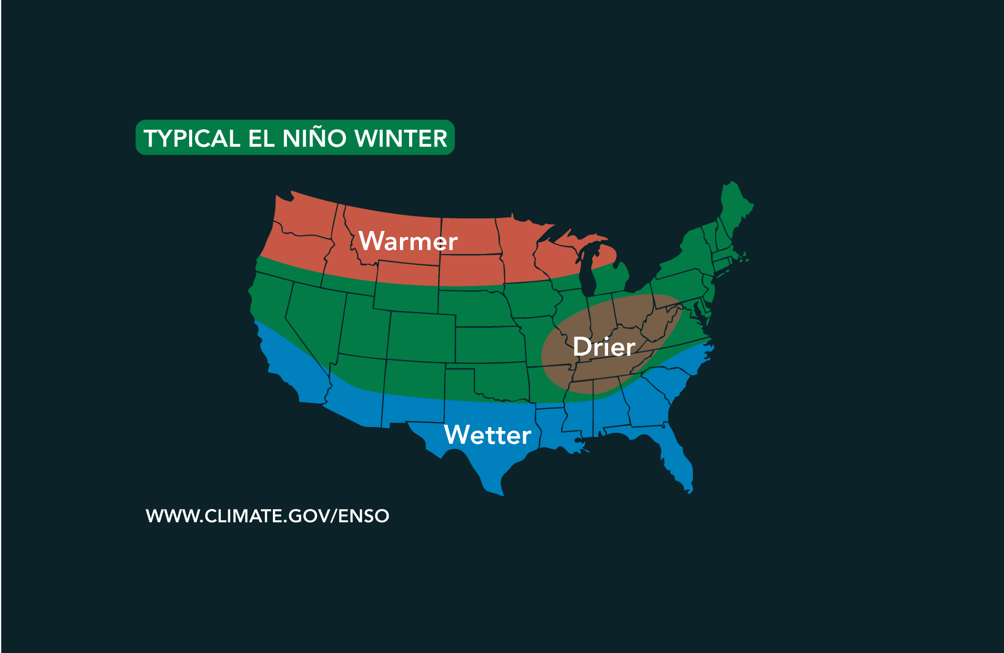 Potential El Niño to affect Kansas agriculture
Student critically injured after falling 70 feet in effort to avoid incoming vehicle • 2338 views College of Arts and Sciences to face future budget cuts • 2090 views K-State President Richard Linton to leave Wildcats…
-
 Tracking a warm & mostly dry weekend ahead
Abigail McCluskey is the Hometown This Morning Storm Tracker Meteorologist at KQ2 News. Good morning and happy Friday! We are wrapping up the workweek with another beautiful, unseasonably warm day across northwest…
-
 No tricks, just treats! Great weather through the weekend
KANSAS CITY, Mo. (KCTV) - With Halloween just around the corner, you could say this forecast is a real treat! Warm, dry and pleasant conditions last through the weekend. Friday: Another Great Day! Warm Weekend with…
Sun & moon
Almanac
MonthlyManhattan, records since 1893. Normals 1991–2020. Data from NOAA's Regional Climate Centers (ACIS).
Nearby
- Manhattan 22 km
- Junction City 9 km
- Abilene 41 km
- Wamego 45 km
- Clay Center 40 km
- Herington 50 km
- Ogden 9 km
- Council Grove 57 km
Forecasters' discussion
From the National Weather Service office in TOP, issued 1 hr ago
Key Messages
- Cooler today with rain chances coming to an end this morning. Some isolated showers and weak storms may return late tonight into Wednesday morning.
- Next rain/storm chances return by Wednesday night as a cold front moves into northern Kansas. Any storms are expected to remain sub- severe.
- The best chances (50-70%) for rain/storms come Thursday night into Saturday morning then again on Monday.
Discussion
Issued at 306 AM CDT Tue Oct 27 2026
Latest water vapor imagery this morning shows a subtle shortwave working its way into eastern Kansas as a deeper shortwave pushes into the northern Rockies/Plains. The shortwave over Kansas has deepened an inverted trough over central and northeastern Kansas that has increased low-level isentropic ascent across the CWA. Light showers continue within this corridor of ascent. As the shortwave slowly moves into western Missouri later this morning, subsidence behind the wave should bring a quick end to precipitation. Given the ample cloud cover and weak troughing across the area, temperatures will not warm much this afternoon, topping out in the lower 70s with some upper 60s across far north-central Kansas. Overnight tonight, the shortwave over the northern Rockies region begins to move into the WY Basin with subtle mid-level energy embedded in the southwest flow to its south. The subtle cooling aloft ahead of the shortwave axis and low-level isentropic ascent may be enough to develop some isolated to scattered showers/weak thunderstorms in the early morning hours Wednesday.
The shortwave over the northern Plains will continue to track east through the day Wednesday and help to push a lee surface trough ahead through the region. As the surface trough moves across the Plains, tight pressure gradients will return gusty southerly flow across Kansas and push a corridor of 60 degree Tds into eastern Kansas. The surface boundary tracks into northern Kansas by the later afternoon/evening creating a focal point for showers and storms. Storms that do develop along the front in the evening will likely remain sub-severe given the lack of deep shear aloft, but given RAP analysis depicting 1000-1500 J/kg of MLCAPE, a few storms could briefly be on the stronger side.
Persistent rain/storm chances (30-60%) look to continue again Thursday night into Friday morning as the surface boundary stalls near the KS/NE border. With warm and moist southerly flow overriding the boundary, widespread showers will be expected. This will quickly be follow up with the next system moving in from the southern Plains, keeping rain and storm chances across the region into Saturday (50-70%). Given the precipitation chances and ample cloud cover, temperatures will not warm much above the low 70 Saturday into next week. The active pattern appears to remain in place as we head into next week. That said, some dry weather should find eastern Kansas by Saturday night into most of Sunday as subsidence and mid- level ridging build in from the southwest.
Aviation
Issued at 1229 AM CDT Tue Oct 27 2026
Rain showers will shortly move into the KMHK terminal with showers expected to persist until around sunrise today. High-res models keep MVFR and IFR CIGs further west behind the cold front, but could see some scattered lower decks accompany rain showers at KMHK. KTOP and KFOE will remain mostly dry with rain mostly falling apart by mid morning. Cannot rule out some isolated showers, but confidence in the coverage of showers was not enough to add mention at this point. The remainder of the period will see VFR stratus overspreading the terminals as the boundary layer mixes out through the afternoon.
Top Watches
None.
Forecasts, observations and alerts in the United States come from the National Weather Service (NOAA); radar from NOAA's Multi-Radar Multi-Sensor system; satellite imagery from NASA's Global Imagery Browse Services (GIBS) and NOAA's GOES satellites; the map from the U.S. Geological Survey's National Map; air quality from AirNow (EPA and its partners); hurricane information from the National Hurricane Center; climate normals and records from NOAA's Regional Climate Centers (ACIS). Forecasts outside the United States and the UV index: MET Norway (CC BY 4.0); observations outside the U.S.: airport reports via NOAA's Aviation Weather Center. Place names: GeoNames (CC BY 4.0). Data are copied on a schedule and may lag the sources; for warnings that affect your safety, follow your local National Weather Service office and emergency officials. Weather news is drawn from the 4Search index and reflects what the press published. Terms of use. How to use Weather