Install
White Hall, IL Weather
Current conditions
Observed at Jacksonville Municipal Airport · 1 hr ago
Forecast
10-day-
Overnight
Partly cloudy, with a low around 47. Southeast wind around 5 mph.
-
Saturday
Mostly sunny, with a high near 76. Southeast wind around 6 mph.
-
Saturday Night
Partly cloudy, with a low around 48. Southeast wind around 3 mph.
National Weather Service forecast updated 4 hrs ago.
Hourly
Hourly forecast- Now51°
- 3 AM50°
- 4 AM49°
- 5 AM48°
- 6 AM47°
- 7 AM47°
- 8 AM48°
- 9 AM54°
- 10 AM61°
- 11 AM65°
- 12 PM70°
- 1 PM72°
- 2 PM74°
- 3 PM74°
- 4 PM75°
- 5 PM73°
- 6 PM70°
- 7 PM65°
- 8 PM59°
- 9 PM58°
- 10 PM56°
- 11 PM55°
- Sun12 AM54°
- 1 AM53°
10-day forecast
Details- TonightOct 23Partly Cloudy47°
- TodayOct 24Mostly Sunny48°76°
- SunOct 25Mostly Sunny50°78°
- MonOct 26Partly Sunny50°77°
- TueOct 27Partly Sunny50°75°
- WedOct 28Mostly Sunny51°77°
- ThuOct 29Mostly Sunny13%46°74°
- FriOct 30Slight Chance Rain Showers17%71°
- SatOct 31Cloudy57°76°
- SunNov 1Light rain0.61 in63°78°
Days after the National Weather Service's seven are MET Norway's outlook, a computer model with no forecaster's review.
Radar
Full mapWeather news in Illinois
More weather news- Capitol Fax.com - Your Illinois News Radar » Good morning!
Thursday, Oct 22, 2026 - Posted by Isabel Miller DOMi & JD BECK, Herbie Hancock… - Barton - Thursday, Oct 22, 26 @ 8:53 am: Oh yeah, and you have to monitor comments between it all. Thank you for the lessons…
-
 Strong El Niño likely means a milder winter for northern Illinois, climatologist says
After a record tornado year, northern Illinois may get a break: forecasters favor a warmer-than-average winter as El Niño strengthens in the Pacific. El Niño refers to a warming of the Pacific Ocean’s surface that…
-
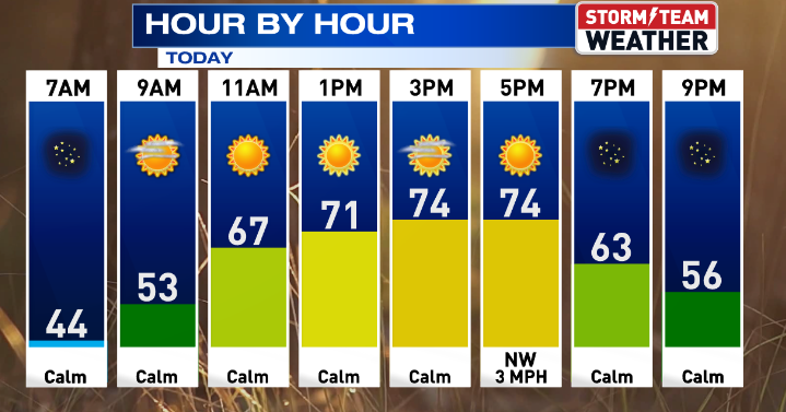 Gorgeous weather continues for Central Illinois
WEDNESDAY: Warming up with sunny skies and calm conditions. High: 75 Low: 47 THURSDAY: Above average with sunny skies. High: 76 Low: 47 FRIDAY: Nice weather continues with sunny skies. High: 76 Low: 46 SATURDAY: Some…
-
 Another beautiful day ahead for Central Illinois
DECATUR, Ill. (WAND) – If you’re looking for a reason to get outside, Tuesday is your day. A high-pressure system settling over the Midwest is bringing abundant sunshine and calm winds to Central Illinois, with…
- Central Illinois Winter Weather Outlook
The winter weather outlook for central and southeast Illinois has been released, and a detailed summary is available at this link. Some of the highlights: Current Conditions Latest Observations Daily Climate Maps…
-
 One of the year’s most pleasant weather stretches arrives in Central Illinois
DECATUR, Ill. (WAND) – A beautiful stretch of sunshine and mild temperatures is settling into the region, and it’s the perfect time to get outside and enjoy it. High pressure is taking control of the Midwest, locking in…
-
 A great week ahead for Central Illinois
WAND DECATUR, Ill. (WAND) – A wonderful weekend across Central Illinois carries into the start of the workweek. Overnight lows dip back into the upper 30s tonight with a small risk for patchy frost, though coverage will…
-
 Sunshine, chilly mornings and a big warm-up ahead for central Illinois
CENTRAL ILLINOIS (25News Now) - Fall is making an appearance across central Illinois this weekend, but don’t get too comfortable with the chilly temperatures. After a cold start on Sunday morning, sunshine will help…
-
 Overnight Frost Advisory for parts of Illinois, NW Indiana
CBS News Colorado 10pm Saturday CBS News Detroit Weekend 11pm CBS News Los Angeles Weekend 9pm CBS News Philadelphia Weekend 11pm KDKA News Weekend 11pm CBS News Texas Weekend 10pm
-
 Frost advisory back in effect for Central Illinois
WAND DECATUR, Ill. (WAND) – Another cool day starts the weekend across Central Illinois with highs Saturday only reaching the upper 50s under plenty of sunny skies. Strong high pressure remains in control keeping skies…
Air quality
Acceptable. Unusually sensitive people should consider limiting prolonged outdoor exertion.
Forecast
- SatModerate
- SunModerate
- MonModerate
Springfield, IL reporting area · 1 hr ago. Data from AirNow (EPA and its state, local and tribal partners); preliminary and subject to change.
Sun & moon
Almanac
MonthlyWhite Hall 1 E, records since 1887. Normals 1991–2020. Data from NOAA's Regional Climate Centers (ACIS).
Nearby
- Jacksonville 36 km
- Godfrey 57 km
- Jerseyville 36 km
- Carlinville 48 km
- Auburn 59 km
- Pittsfield 39 km
- Virden 55 km
- Louisiana 56 km
- South Jacksonville 34 km
- Carrollton 15 km
- Brighton 50 km
- Girard 53 km
Forecasters' discussion
From the National Weather Service office in LSX, issued 2 hrs ago
Key Messages
- High pressure remains in place allowing for our dry and warm weather continues well into next week.
Short Term
Issued at 148 PM CDT Fri Oct 23 2026
An upper-level ridge will remain positioned over the Mid-Mississippi River Valley through Sunday, stagnated by the configuration of the wave pattern into an Omega Block. This pattern will result in very little change in sensible weather from day to day with seasonably warm temperatures and dry conditions. The only change through the weekend will be the very slow departure of a surface high pressure center and upper-level clouds of varying thickness streaming overhead by Saturday through Sunday. The most pronounced nocturnal radiational cooling during the period will be across southeastern MO/southwestern IL and/or river valleys with low temperatures in the 40s F and patchy morning fog, mainly low temperatures in the 50s F elsewhere. High temperatures will continue to be in the 70s F, near 80 F on Sunday depending on the thickness of cloud cover.
Long Term
Issued at 148 PM CDT Fri Oct 23 2026
Global model guidance is coming into better agreement on the ejection of an upper-level trough into the Central/Northern Plains and Upper Midwest Monday through Tuesday as the Omega Block breaks down. With this track of the trough, it is increasingly likely that the associated cold front does not reach the CWA, favoring similar, seasonably warm temperatures continuing along with dry conditions.
It is not until late next week now, that there are any signs for our sensible weather to change with varying signals for an upper-level trough to propagate into the north-central CONUS. However, the track and amplitude of the trough is uncertain which will influence its ability to force an associated cold front east/southeastward. If the front reaches the CWA, it would be accompanied by an opportunity for rain and temperatures cooling closer to average late next week. If the front fails to reach the CWA, there would be no clear catalyst for seasonably warm temperatures and dry conditions to end. Ensemble model guidance cluster analysis depicts these scenarios all being valid possible outcomes at this point. Taking all scenarios into consideration, probabilities of measurable rainfall range from 20 to 50 percent Thursday, onward, along with NBM interquartile ranges increasing to between 10 and 20 F.
Aviation
Issued at 1220 AM CDT Sat Oct 24 2026
High pressure continues to bring calm winds and VFR conditions. There continues to be a daily threat of fog in the valleys each morning, but thus far some high level cirrus clouds are providing enough of a blanket tonight to make this less likely than previous nights. However, if these clouds disperse then locally greater cooling may lead to local instances of fog through 12 or 13Z. The greatest chances are at SUS or CPS.
Forecasts, observations and alerts in the United States come from the National Weather Service (NOAA); radar from NOAA's Multi-Radar Multi-Sensor system; satellite imagery from NASA's Global Imagery Browse Services (GIBS) and NOAA's GOES satellites; the map from the U.S. Geological Survey's National Map; air quality from AirNow (EPA and its partners); hurricane information from the National Hurricane Center; climate normals and records from NOAA's Regional Climate Centers (ACIS). Forecasts outside the United States and the UV index: MET Norway (CC BY 4.0); observations outside the U.S.: airport reports via NOAA's Aviation Weather Center. Place names: GeoNames (CC BY 4.0). Data are copied on a schedule and may lag the sources; for warnings that affect your safety, follow your local National Weather Service office and emergency officials. Weather news is drawn from the 4Search index and reflects what the press published. Terms of use.