Install
Davenport, IA Weather
Current conditions
Observed at Moline Quad-City Airport · 34 min ago
Forecast
10-day-
Sunday
Mostly sunny, with a high near 77. South wind around 5 mph.
-
Sunday Night
Mostly cloudy, with a low around 54.
-
Monday
Partly sunny, with a high near 72.
National Weather Service forecast updated 1 day ago.
Hourly
Hourly forecast- Now54°
- 8 AM55°
- 9 AM58°
- 10 AM62°
- 11 AM66°
- 12 PM70°
- 1 PM73°
- 2 PM75°
- 3 PM77°
- 4 PM77°
- 5 PM75°
- 6 PM72°
- 7 PM68°
- 8 PM65°
- 9 PM63°
- 10 PM61°
- 11 PM60°
- Mon12 AM59°
- 1 AM58°
- 2 AM57°
- 3 AM56°
- 4 AM55°
- 5 AM54°
- 6 AM54°
10-day forecast
Details- TonightOct 23Partly Cloudy55°
- SatOct 24Mostly Sunny54°76°
- TodayOct 25Mostly Sunny54°77°
- MonOct 26Partly Sunny51°72°
- TueOct 27Mostly Cloudy11%53°69°
- WedOct 28Mostly Sunny16%52°73°
- ThuOct 29Slight Chance Rain Showers18%46°68°
- FriOct 30Slight Chance Rain Showers23%65°
- SatOct 31Partly cloudy40°60°
- SunNov 1Cloudy55°67°
Days after the National Weather Service's seven are MET Norway's outlook, a computer model with no forecaster's review.
Radar
Full mapWeather news near Davenport
More weather news- Newly released winter outlook favors milder winter as super El Nino builds
DAVENPORT, Iowa (KWQC) - NOAA has released its official winter weather outlook for the 2026-2027 season, highlighting the Quad Cities region in a potential pattern for above-average temperatures. The primary driver…
-
 First Alert Forecast: October warmth on the way
KWQC First Alert Forecast: October warmth on the way River Drive to be reduced to one lane ‘Get drunk enough’: Davenport man arrested for allegedly grooming, providing child with alcohol
- Eastern Iowa Weather This Weekend: Frost Risk, Then 70° Monday Oct 19
Davenport, IA – A chilly start to Saturday, October 17, will give way to sunshine and a noticeable warmup across the Quad Cities, although another cold night could bring patchy frost Sunday morning. Temperatures are…
-
 Dangerous Freeze Warnings Issued for Iowa, Wisconsin, Minnesota and Illinois as Temperatures Drop
Freeze Warnings take effect early Saturday across much of Iowa, Wisconsin, southeast and central Minnesota and northern Illinois, with lows as cold as 26 degrees expected. Seven National Weather Service offices issued…
-
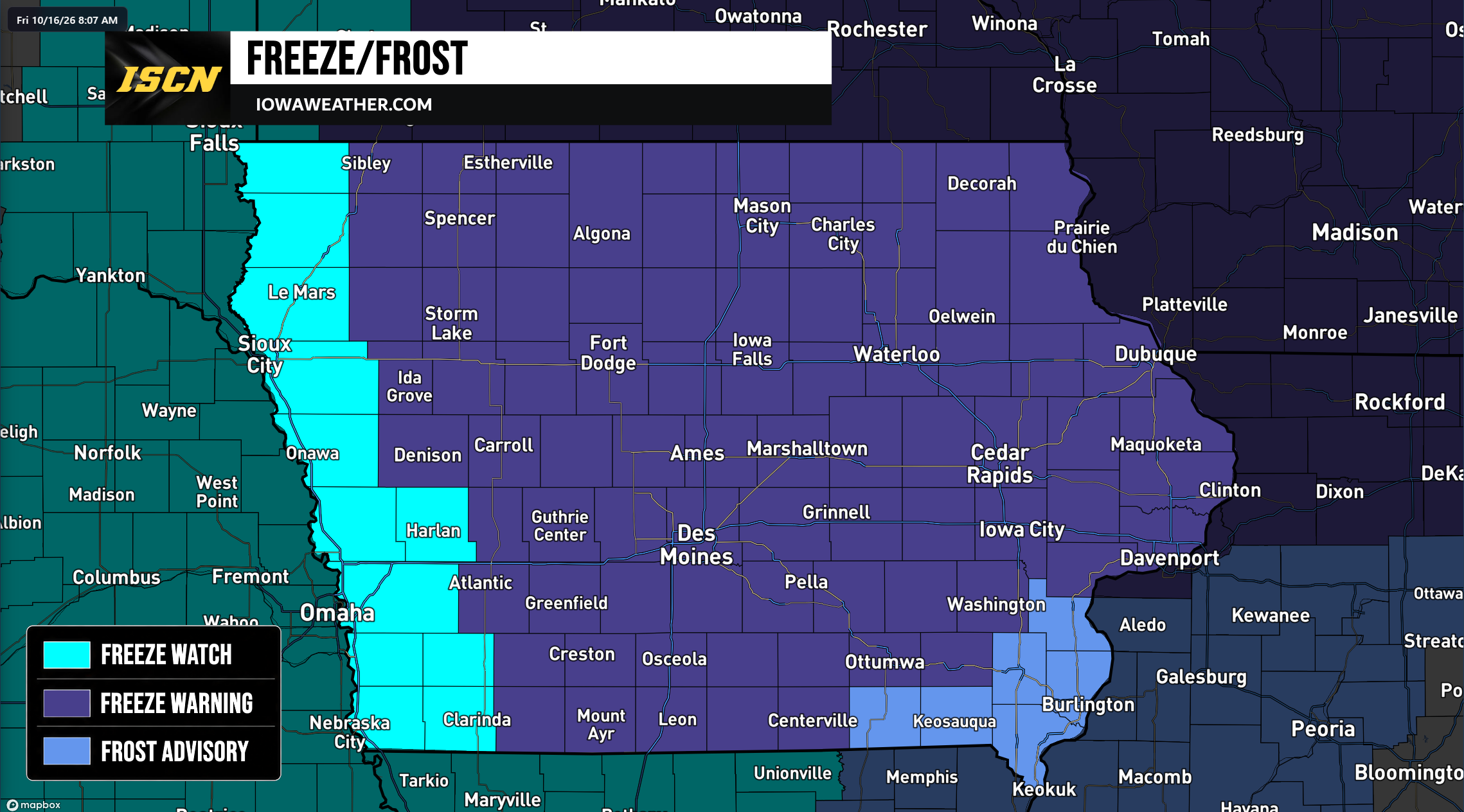 Widespread Freeze Warnings Issued Across Iowa as Temperatures Could Drop Into the 20s Saturday Morning
A widespread round of freezing temperatures is expected across Iowa early Saturday morning, prompting the National Weather Service to issue Freeze Warnings, Freeze Watches, and Frost Advisories for the entire state…
- Orlando Weather Forecast: Sunny Thursday Before Stormy, Windy Weekend
Thursday should remain mostly sunny, with a high near 90 and an east-northeast breeze of 5 to 10 mph. Rain chances stay low through the day, though a few coastal showers could drift inland later in the afternoon…
-
 Trudy strengthens to a hurricane as system nears Mexico’s coast with major storm expected
KWQC Trudy was located about 300 miles (480 kilometers) southwest of Acapulco, Mexico, with maximum sustained winds of 75 mph (120 kph), according to the U.S. National Hurricane Center in Miami. The hurricane was moving…
-
 Matt Davenport's Storm Tracker Forecast for Thursday, October 15
KPVI Warmer weather is on the way for the weekend. Local Woman Sentenced to Prison One of Colorado's Most Wanted Sex Offenders Was Found in Wyoming Rooster Makes an Appearance on Tail-Wagger Wednesday Friends of…
-
 Fall Yard Cleanup in the Quad Cities: What to Do Before Winter Arrives
Other News Of Interest As fall arrives in the Quad Cities, homeowners in Davenport, Bettendorf, Moline, and Rock Island begin preparing their yards for colder weather. Falling leaves, cooler temperatures, and shorter…
-
 Matt Davenport's Storm Tracker Forecast for Tuesday, October 13
KPVI One more day of rainy weather before things begin to warm up. American Falls Police Seeking Information on Missing Person Rain Didn't Stop the Community from Coming Out for ISU Homecoming Parade The City of Idaho…
Air quality
Air quality is satisfactory, and air pollution poses little or no risk.
Forecast
- SunModerate
- MonModerate
Rock Island-Moline, IL reporting area · 2 hrs ago. Data from AirNow (EPA and its state, local and tribal partners); preliminary and subject to change.
Sun & moon
Almanac
MonthlyMoline Area, records since 1874. Normals 1991–2020. Data from NOAA's Regional Climate Centers (ACIS).
Nearby
- Moline 6 km
- Rock Island 2 km
- Bettendorf 5 km
- Clinton 48 km
- Muscatine 40 km
- East Moline 11 km
- Silvis 14 km
- Geneseo 36 km
- Eldridge 15 km
- De Witt 33 km
- Colona 19 km
- Milan 8 km
Forecasters' discussion
From the National Weather Service office in DVN, issued 57 min ago
Key Messages
- Unseasonably mild fall weather will continue through the work week with passing clouds and light winds.
- Mostly dry conditions are expected through Tuesday with rain chances gradually increasing as we head towards the end of the week.
Short Term
Issued at 1248 AM CDT Sun Oct 25 2026
Today is going to be another unseasonably mild day with highs in the mid-to-upper 70s as a dry cold front stalls out near the Highway 20 corridor. A 1038 mb Canadian high pressure will eventually push the boundary further south towards the Highway 34 corridor overnight tonight, but the limited dry air behind the front is expected to keep lows in the upper 40s to mid-50s.
Heading into Monday, a low pressure will deepen across the Central Plains as a shortwave trough lifts into the Dakotas. With easterly flow across much of the CWA, some slightly cooler air advects in from the Great Lakes with highs in the upper 60s to mid-70s. By Monday night, the low pressure skirts off to the north-northeast into the southern Minnesota and pulls the boundary near Highway 34 northward. A narrow band of mid-level moisture from the tropical Pacific could support spotty rain showers (< 10% coverage).
Long Term
Issued at 1248 AM CDT Sun Oct 25 2026
Tuesday-Thursday...The next shortwave trough rotates into the Northern Plains, spawning another low pressure system across the Dakotas. Diffluent flow ahead of a jet streak in the base of this trough is expected to slowly deepen this new low as it treks into Minnesota and southern Ontario Tuesday night into Wednesday. A weak cold front will slide into Iowa, but similar to today, it will stall out across the state heading into Wednesday night. Lingering moisture from the Pacific though keeps isolated PoPs (20-40%) around Wednesday into Thursday.
Friday-Saturday...Another weak trough in the subtropical jet stream is pulled northward into the Central Plains by a longwave trough digging into the western CONUS. A sense of deju vu sets in on Friday with surface cyclogenesis occurring along the Front Range of the Rockies and easterly surface flow returning with a high pressure over the Great Lakes. By Saturday, the remnants of the boundary left across Iowa is lifted northward, and southerly flow returns. This will set the stage for a more active pattern going into the first days of November.
Aviation
Issued at 603 AM CDT Sun Oct 25 2026
VFR conditions are expected through the next 24hours with light winds and high clouds moving over the area. A weak front will move southeast over the area late tonight, (early Monday), which will bring some light wind northeast winds north of Interstate 80. Dry air will keep any rain from falling from the mid and high cloud tonight around the front.
Forecasts, observations and alerts in the United States come from the National Weather Service (NOAA); radar from NOAA's Multi-Radar Multi-Sensor system; satellite imagery from NASA's Global Imagery Browse Services (GIBS) and NOAA's GOES satellites; the map from the U.S. Geological Survey's National Map; air quality from AirNow (EPA and its partners); hurricane information from the National Hurricane Center; climate normals and records from NOAA's Regional Climate Centers (ACIS). Forecasts outside the United States and the UV index: MET Norway (CC BY 4.0); observations outside the U.S.: airport reports via NOAA's Aviation Weather Center. Place names: GeoNames (CC BY 4.0). Data are copied on a schedule and may lag the sources; for warnings that affect your safety, follow your local National Weather Service office and emergency officials. Weather news is drawn from the 4Search index and reflects what the press published. Terms of use.