Install
Vail, CO Weather
Current conditions
Observed at GW3823 VAIL · 1 hr ago
Forecast
10-day-
Today
Mostly sunny, with a high near 57. West wind 0 to 5 mph.
-
Tonight
Mostly clear, with a low around 34. South southeast wind 0 to 5 mph.
-
Wednesday
Partly sunny, with a high near 62. South wind 0 to 5 mph.
National Weather Service forecast updated 5 hrs ago.
Hourly
Hourly forecast- Now35°
- 8 AM35°
- 9 AM38°
- 10 AM42°11%
- 11 AM48°12%
- 12 PM52°14%
- 1 PM54°14%
- 2 PM55°14%
- 3 PM57°14%
- 4 PM57°12%
- 5 PM55°11%
- 6 PM52°
- 7 PM48°
- 8 PM45°
- 9 PM43°
- 10 PM42°
- 11 PM40°
- Wed12 AM38°
- 1 AM38°
- 2 AM36°
- 3 AM36°
- 4 AM35°
- 5 AM35°
- 6 AM35°
10-day forecast
Details- TodayOct 20Mostly Sunny14%34°57°
- WedOct 21Partly Sunny61%40°62°
- ThuOct 22Showers And Thunderstorms83%40°60°
- FriOct 23Slight Chance T-storms29%32°56°
- SatOct 24Chance Snow Showers44%29°51°
- SunOct 25Slight Chance Snow Showers then Sunny15%31°55°
- MonOct 26Mostly Sunny32°58°
- TueOct 27Cloudy0.02 in24°45°
- WedOct 28Partly cloudy22°51°
- ThuOct 29Cloudy27°52°
Days after the National Weather Service's seven are MET Norway's outlook, a computer model with no forecaster's review.
Radar
Full mapWeather news near Vail
More weather news-
 Trudy strengthens to a hurricane as system nears Mexico’s coast with major storm expected
Trudy has intensified into a Category 1 hurricane as it approaches the Pacific coast of Mexico. Trudy was located about 300 miles (480 kilometers) southwest of Acapulco, Mexico, with maximum sustained winds of 75 mph…
-
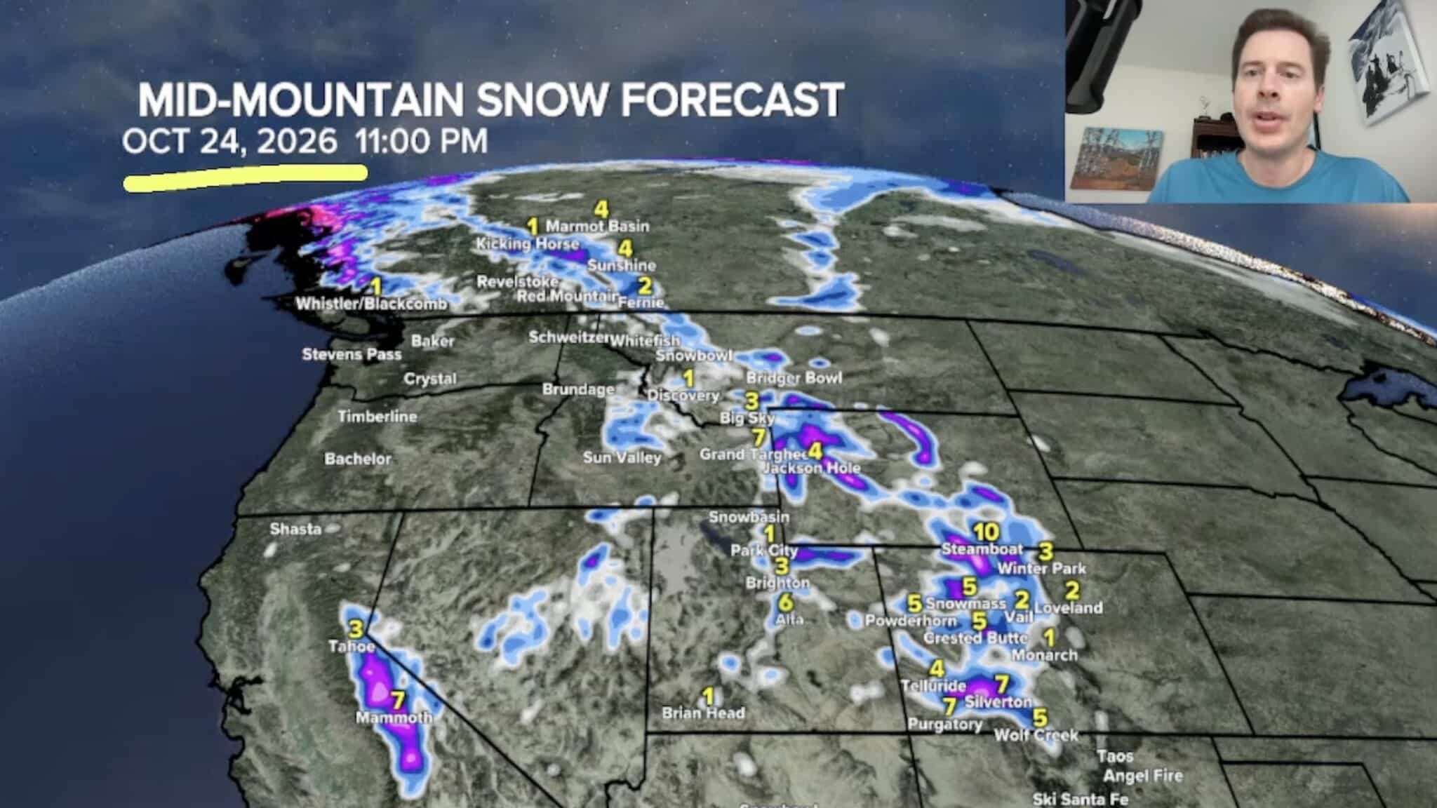 Sierra Nevada, Colorado, and Wyoming Could See A Lot More Snow Next Week
The Sierra Nevada is positioned to receive some of the highest snowfall totals in Tomer’s latest forecast. The incoming storm is expected to dig south into California, generating snowfall across the High Sierra. Tomer…
-
 Rain and mountain snow end, now we’re turning colder
The last of the rain and mountain snow will end tonight and Thursday morning, then we’ll turn noticeably colder. GRAND JUNCTION, Colo. (KKCO) - The last of the rain and mountain snow will end tonight and Thursday…
-
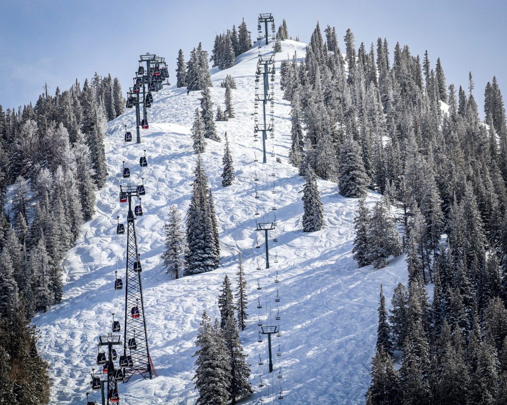 Colorado mountains see first real snow of the season, with more on the way
NewsNews | Oct 14, 2026 As rain transitions to snow in the forecast, several Colorado mountains are preparing to receive their first meaningful snow of the season. As of Wednesday morning, Oct. 14, weather station…
-
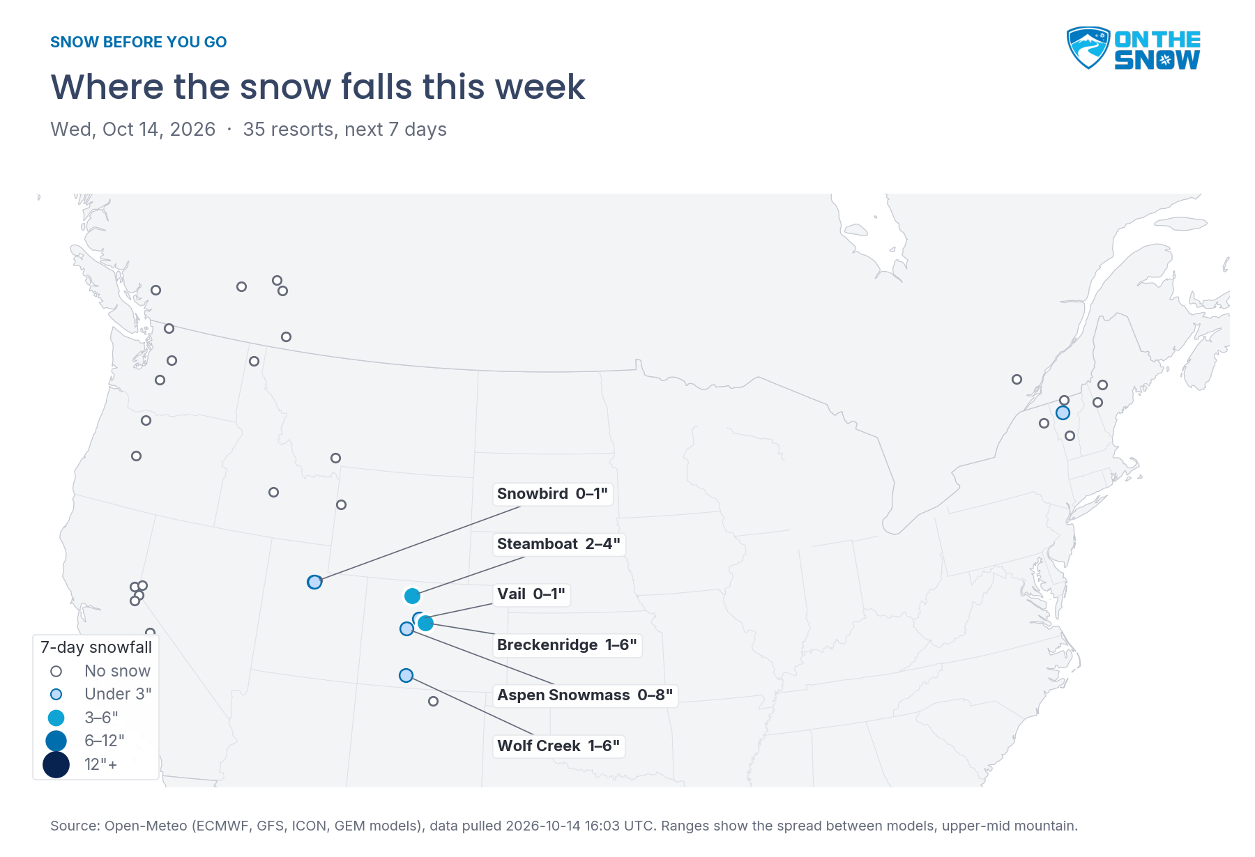 Snow Before You Go: Where to Find the Best Snow This Week
OnTheSnow.com Colorado gets a real taste of winter today through Thursday. Steamboat picks up 2–4 inches, and Breckenridge, Aspen Snowmass, and Wolf Creek could see a few inches each, though the models disagree on how…
-
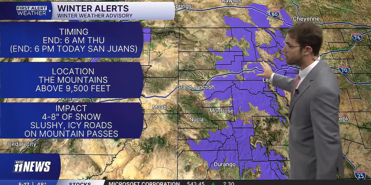 Periods of valley rain & mountain snow with winter weather advisories, clearing Thursday afternoon
Periods of rain in the valleys with mountain snow continuing until Thursday afternoon. Near and cooler than normal temperatures this week. GRAND JUNCTION, Colo. (KKCO) - Periods of rain in the valleys with mountain snow…
-
 Colorado Winter Weather Advisory: Up to 12 Inches of Snow Expected as Winter Storm Approaches
DENVER, Aktualita.co — Colorado is preparing for a significant round of early-season winter weather as the National Weather Service (NWS) issues multiple Winter Weather Advisories across the state's mountain regions…
- Vail Mountain & Beaver Creek to begin snowmaking operations after 1st snowfall
The first snow of the season has fallen at Vail Mountain, Beaver Creek Resort and Butte Mountain Resort. According to officials, Vail Mountain received nearly three inches of snow and Beaver Creek got around an inch of…
-
 Urgent Winter Weather Advisories Issued for 30 Counties in Colorado as Conditions Intensify
Winter Weather Advisories take effect Wednesday for Colorado’s high country, with 4 to 12 inches of snow expected near Aspen, Vail, Winter Park, Breckenridge, Telluride and Wolf Creek Pass. Four National Weather Service…
-
 Snowfall to reach double digits on some Western Slope mountains
NewsNews | Oct 13, 2026 Colorado’s High Country could see up to 12 inches of snow through Thursday morning as a storm moves through the western mountains, according to a winter weather advisory published by the National…
Air quality
Air quality is satisfactory, and air pollution poses little or no risk.
Forecast
- TueGood
Aspen, CO reporting area · 46 min ago. Data from AirNow (EPA and its state, local and tribal partners); preliminary and subject to change.
Sun & moon
Almanac
MonthlyClimax, records since 1895. Normals 1991–2020. Data from NOAA's Regional Climate Centers (ACIS).
Nearby
- Edwards 19 km
- Gypsum 49 km
- Eagle 39 km
- Avon 13 km
- Breckenridge 34 km
- Silverthorne 26 km
- Frisco 25 km
- Leadville 44 km
Forecasters' discussion
From the National Weather Service office in GJT, issued 1 hr ago
Key Messages
- Isolated showers and seasonable temperatures continue Tuesday.
- Widespread rain returns Wednesday through Friday.
- The potential for flooding increases Thursday and Friday especially for portions of southeast Utah and southwest Colorado.
- Rainfall amounts in the southern mountains range from 1-3 inches with locally higher amounts possible in the San Juans.
Discussion
Issued at 1102 PM MDT Mon Oct 19 2026
High pressure over the Gulf drifting west into Mexico and a deep low currently off the Oregon Coast descending south off the West Coast will dominate the weather pattern through the rest of the week and possibly into early next week. The current southwesterly flow is pulling Pacific moisture up through Southern California and the Desert Southwest into the region that supported weak isolated light showers with a few thunderstorms today, and will again tomorrow, but coverage does look to be a little more isolated. As the low bottoms out off the Southern California Coast by Wednesday morning, turning to the northeast to track up across the Great Basin and Utah by Friday, the High pressure moves in over northeastern Mexico to set up a more southerly flow than we saw with the last tropical surge of moisture. This scenario sets the deeper plume of tropical moisture from the remnants of Hurricane Trudy to plow into the southern mountains where current guidance has the bulk of the rain falling, and casting a rain shadow to the north in the central and northern mountains. This being said, there is still a lot of uncertainty creeping into the forecast as early as Wednesday. The latest guidance is sliding the moist plume to the west a bit that would allow more moisture to push north into southern Utah and to the east into the central and northern Colorado areas. The Atmospheric River (AR) models do support this solution with Integrated Vapor Transport (IVT) values up to 500 kg/m/s pushing into the central and northern areas. As a result, storm totals have increased to one to two inches rain in the central mountains and up to an inch farther north. Mean while the southern face of the San Juan and Abajo Mountains will see two to three inches rain with locally higher amounts possible. This system is a very warm system with snow levels remaining above 12K ft through Thursday creating a risk for receiving rain on snow through the southern mountains that can lead to high stream flows across the southern areas of Colorado and Utah. In fact, the River Forecast Center is forecasting some of the rivers in this area to reach flood stage with this system. Understand that the forecast remains fluid at this time, and key details will shift over the coming days. Stay tuned for updates on this. Look for the heaviest rains to fall Wednesday night into Thursday as cooler air and stronger jet dynamics move in aloft supporting stronger thunderstorms with periods of heavy rain. These stronger storms may lead to localized flash flooding possible across much of eastern Utah and Western Colorado. Stay tuned on this too as the forecast develops.
The showers and thunderstorms will taper off Friday as drier air moves in from the southwest. As the low passes to the northwest, it will drag a cold front across the northern areas Friday mostly along and north of I-70, dropping temperatures from Thursday's highs about ten degrees. Residual moisture across the region will spawn showers mostly over the higher terrain Saturday afternoon and again Sunday before things are finished.
Aviation
Issued at 550 AM MDT Tue Oct 20 2026
FEW to BKN mid and low level clouds continue to move across the area. A few sites have briefly dropped below ILS breakpoints or to MVFR to LIFR conditions this morning as these low clouds move through. This cloud cover may persist through the afternoon, but there are low chances of TAF site impacts. A few isolated showers or thunderstorms are possible over the high terrain today. Showers become more likely in the Four Corners region towards the end of the TAF period. Winds will be light and terrain driven.
Hydrology
Issued at 300 PM MDT Mon Oct 19 2026
Strong southwesterly winds develop overhead on Wednesday, which will open the atmospheric flood gates and draw in moisture tied to Tropical Storm Trudy. Yet another decaying tropical system will fuel widespread showers across the Desert Southwest and southern Colorado Rockies through the end of the week. Rainfall totals are subject to change, however, current guidance shows 1 to 3 inches of rain across the Four Corners region, with locally higher amounts expected. The warm tropical moisture is also throwing a wrecking ball at normal snow levels for this time of year, with rain possible above 12,000' through Thursday. SNOTEL sites across the San Juans indicate 1 to 2 inches of SWE accumulated from last week's storms. If the the warm tropical moisture arrives as rain up high, we can anticipate accelerated runoff due to rain on snow for our upper level basins.
In addition, convective storms are not out of the question, preceding and following the main atmospheric plume of moisture. Heavy rainfall rates ahead of the system (i.e. Wednesday afternoon) may locally enhance water levels in rivers and washes, or at least, prime soils for more efficient runoff come Thursday. Confidence in the details of heavy precipitation rates and coverage are low at this time, but certainly noteworthy for the event's entirety.
The complexity Trudy brings, in terms of precipitation rates, totals and temperatures, raises our concern for another round of flooding and flash flooding of rivers, streams, creeks and normally dry arroyos. The latest river forecasts provided by CBRFC suggest minor flooding for the San Juan River, near Pagosa Springs, CO. In addition, rivers reaching bankfull to near minor flood stage is possible for the Piedra and Animas basins, with a 1 to 2 foot rise expected in nearby basins. Although timing is likely to change, expect a rapid rise in rivers, creeks, and dry washes Thursday into Friday.
Forecasts, observations and alerts in the United States come from the National Weather Service (NOAA); radar from NOAA's Multi-Radar Multi-Sensor system; satellite imagery from NASA's Global Imagery Browse Services (GIBS) and NOAA's GOES satellites; the map from the U.S. Geological Survey's National Map; air quality from AirNow (EPA and its partners); hurricane information from the National Hurricane Center; climate normals and records from NOAA's Regional Climate Centers (ACIS). Forecasts outside the United States and the UV index: MET Norway (CC BY 4.0); observations outside the U.S.: airport reports via NOAA's Aviation Weather Center. Place names: GeoNames (CC BY 4.0). Data are copied on a schedule and may lag the sources; for warnings that affect your safety, follow your local National Weather Service office and emergency officials. Weather news is drawn from the 4Search index and reflects what the press published. Terms of use.