Install
Satsuma, AL Weather
Current conditions
Observed at Mobile, Mobile Regional Airport · 26 min ago
Forecast
10-day-
This Afternoon
Sunny, with a high near 77. Northeast wind around 10 mph.
-
Tonight
Clear, with a low around 54. Northeast wind 5 to 10 mph.
-
Sunday
Sunny, with a high near 79. Northeast wind 10 to 15 mph.
National Weather Service forecast updated 3 hrs ago.
Hourly
Hourly forecast- Now75°
- 6 PM72°
- 7 PM66°
- 8 PM63°
- 9 PM61°
- 10 PM60°
- 11 PM59°
- Sun12 AM57°
- 1 AM56°
- 2 AM56°
- 3 AM55°
- 4 AM55°
- 5 AM54°
- 6 AM54°
- 7 AM54°
- 8 AM56°
- 9 AM62°
- 10 AM67°
- 11 AM71°
- 12 PM74°
- 1 PM77°
- 2 PM77°
- 3 PM78°
- 4 PM79°
Daily forecast
Details- TodayOct 24Sunny54°77°
- SunOct 25Sunny55°79°
- MonOct 26Mostly Sunny52°79°
- TueOct 27Mostly Sunny55°80°
- WedOct 28Mostly Sunny54°81°
- ThuOct 29Sunny57°81°
- FriOct 30Mostly Sunny60°82°
- SatOct 31Cloudy51°78°
Days after the National Weather Service's seven are MET Norway's outlook, a computer model with no forecaster's review.
Radar
Full mapWeather news in Alabama
More weather news-
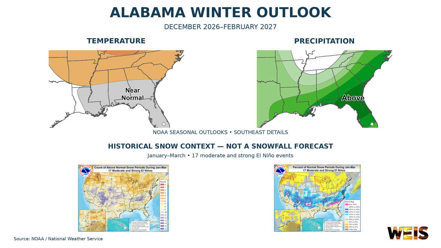 Alabama Winter Outlook Points to Wetter Conditions as El Niño Shapes the Season
CENTRE– Alabama’s winter outlook favors wetter conditions, with the strongest signal across southern Alabama and a weaker signal farther north. The outlook covers December 2026 through February 2027. NOAA released its…
- Could Alabama see perfect Thanksgiving weather? Almanac says yes
Alabama families planning to gather around the Thanksgiving table may have one less thing to worry about this year: the weather. If the Farmers' Almanac's latest forecast holds, the holiday week could bring a welcome…
-
 Alabama News Wire Forecast 10-21-2026
The Alabama News Wire
-
 First Alert Weather: Beautiful fall stretch continues: Mid-70s, sunny and dry across central Alabama
WBRC 6 News BIRMINGHAM, Ala. (WBRC) - The Next 24 Hours: We’re expecting another beautiful fall day across central Alabama, with plenty of sunshine and afternoon temperatures climbing into the mid to upper 70s. Skies…
-
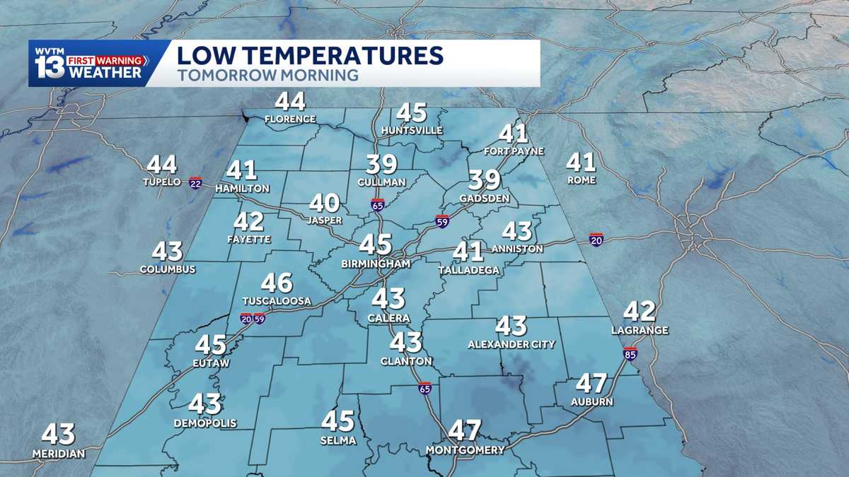 Chilly mornings and sunny, warm days in Alabama's weather forecast this week
MONDAY: Chilly morning lows down in the 40s. Warming up to the 70s with full sunshine in the afternoon. Rain chance: 0%. TUESDAY: Another chilly start in the 40s. Warming to the mid-70s in the afternoon with a light…
-
 Alabama stays rain-free all week as fall warmth builds with low humidity and clear skies
ALABAMA 7 DAY FORECAST Another pleasant fall day is on tap in Alabama as cool and dry conditions persist for another day. An upper-level ridge to our west and a building upper-level trough to our east will keep up in…
-
 Heavy rain possible for parts of Alabama this weekend; here’s where
The National Weather Service is forecasting up to 10 inches of rain for areas near Alabama's Gulf Coast over the weekend. That raises the risk for flash flooding, and a flood watch will be in effect for Mobile and…
Air quality
Air quality is satisfactory, and air pollution poses little or no risk.
Forecast
- SatModerate (64)
- SunModerate (58)
- MonGood (49)
Mobile, AL reporting area · 1 hr ago. Data from AirNow (EPA and its state, local and tribal partners); preliminary and subject to change.
Sun & moon
Almanac
MonthlyMobile Area, records since 1872. Normals 1991–2020. Data from NOAA's Regional Climate Centers (ACIS).
Nearby
- Mobile 18 km
- Daphne 31 km
- Prichard 13 km
- Fairhope 40 km
- Tillmans Corner 31 km
- Saraland 4 km
- Atmore 57 km
- Bay Minette 27 km
- Spanish Fort 24 km
- Theodore 36 km
- Chickasaw 10 km
- Robertsdale 47 km
Forecasters' discussion
From the National Weather Service office in MOB, issued 11 hrs ago
Key Messages
Issued at 636 AM CDT Sat Oct 24 2026
- Moderate to strong northeast winds will create hazardous conditions for small craft over most of the marine area into early next week.
- A High Risk of rip currents is expected for beach areas this morning through Monday night.
Update
Issued at 636 AM CDT Sat Oct 24 2026
The current forecast is on track and no updates are needed. /13
Discussion
Issued at 1052 PM CDT Fri Oct 23 2026
Dry weather prevails across the region for the foreseeable future. Temperatures continue to remain around average for highs generally in the middle to upper 70's most days, with perhaps a spot or two getting above 80 any given day. Overnight lows will generally be below normal in the middle to upper 40's over the interior and lower 50's near the coast.
We remain on the western periphery of upper troughing the next couple days before upper ridging begins moving in overhead. A reinforcing shot of cool, dry air comes in from the northeast Friday into the weekend as Cold Air Damming sets up across the Carolinas tightening up the pressure gradient across the area and reinforcing cool, dry air southwest into our region. The combination of low afternoon relative humidity and gusty winds may result in elevated fire weather concerns this weekend. Caution should be used if any outdoor burning is necessary. A High risk of rip currents goes into effect this morning, lingering through Monday night. The risk will gradually taper into the middle of the week. MM/25
Aviation
(12Z TAFS) Issued at 636 AM CDT Sat Oct 24 2026
VFR conditions will prevail through the next 24 hours. /13
Forecasts, observations and alerts in the United States come from the National Weather Service (NOAA); radar from NOAA's Multi-Radar Multi-Sensor system; satellite imagery from NASA's Global Imagery Browse Services (GIBS) and NOAA's GOES satellites; the map from the U.S. Geological Survey's National Map; air quality from AirNow (EPA and its partners); hurricane information from the National Hurricane Center; climate normals and records from NOAA's Regional Climate Centers (ACIS). Forecasts outside the United States and the UV index: MET Norway (CC BY 4.0); observations outside the U.S.: airport reports via NOAA's Aviation Weather Center. Place names: GeoNames (CC BY 4.0). Data are copied on a schedule and may lag the sources; for warnings that affect your safety, follow your local National Weather Service office and emergency officials. Weather news is drawn from the 4Search index and reflects what the press published. Terms of use.