Install
Chico, CA 95928 Weather
Current conditions
Observed at Chico Municipal Airport · 1 hr ago
Forecast
10-day-
Today
Haze and areas of fog before 10am. Sunny, with a high near 71. Northwest wind 5 to 13 mph, with gusts as high as 24 mph.
-
Tonight
Clear, with a low around 47. North northwest wind 6 to 10 mph, with gusts as high as 21 mph.
-
Saturday
Sunny. High near 75, with temperatures falling to around 73 in the afternoon. Northwest wind 5 to 9 mph.
National Weather Service forecast updated 9 hrs ago.
Hourly
Hourly forecast- Now61°
- 12 PM64°
- 1 PM67°
- 2 PM69°
- 3 PM70°
- 4 PM71°
- 5 PM70°
- 6 PM69°
- 7 PM65°
- 8 PM59°
- 9 PM57°
- 10 PM56°
- 11 PM56°
- Sat12 AM55°
- 1 AM54°
- 2 AM52°
- 3 AM51°
- 4 AM49°
- 5 AM48°
- 6 AM48°
- 7 AM47°
- 8 AM47°
- 9 AM52°
- 10 AM59°
Daily forecast
Details- TodayOct 23Haze then Sunny47°71°
- SatOct 24Sunny45°75°
- SunOct 25Sunny49°74°
- MonOct 26Sunny45°72°
- TueOct 27Sunny45°71°
- WedOct 28Mostly Sunny46°70°
- ThuOct 29Mostly Sunny45°69°
- FriOct 30Cloudy54°74°
- SatOct 31Cloudy0.15 in53°73°
Days after the National Weather Service's seven are MET Norway's outlook, a computer model with no forecaster's review.
Radar
Full mapWeather news near Chico
More weather news-
 Weather service forecasts cooler north state
Chico Enterprise-Record Chico to revisit anti-camping, public nuisance law Paradise considers new aesthetic projects Annual Witch’s Market brings autumnal fun News and talk tops in overall local radio market Oroville…
-
 Fall-like temperatures set to return this week
Action News Now WATCH NOW: Chico City Council District 2 Debate More of what we're used to seeing this time of year here in Northern California is set to return this week. Watch Action News Now
-
 Weekend Forecast: Let the temperature slide begin!
KRCR REDDING, Calif. — The average last 90 degree day of the year is October 10th in Chico, October 11th in Redding, and October 12th in Red Bluff. We've already run past that average here in 2026, but not necessarily…
-
 Elevated fire weather conditions continue across Northern California today
Action News Now WATCH NOW: Chico City Council District 2 Debate Locally gusty winds and very low humidity maintain elevated fire conditions across Northern California today and Saturday. A cooling trend begins this…
- Sacramento Basks In One Last Sunny Weekend Before Rain Crashes Back In
Sacramento is forecast to be sunny Friday, with another 86-degree afternoon ahead. The warm spell holds through Saturday before a sharper cooldown arrives Sunday and Monday, with rain chances finally returning early…
-
 Warm temperatures and dry conditions continue across Northern California
Action News Now WATCH NOW: Chico City Council District 2 Debate Northern California stays warm and dry today, with elevated fire risk through Friday. Cooler temperatures and higher humidity arrive by Sunday. Watch…
-
 Critical fire weather develops east of Chico as gusty winds and low humidity arrive
Action News Now WATCH NOW: Chico City Council District 2 Debate A Red Flag Warning covers the Sierra and adjacent foothills from midnight Wednesday night through Friday morning, where wind gusts could reach 45 mph…
-
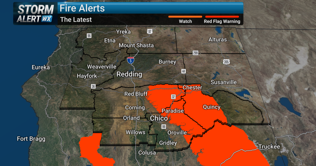 Critical fire weather threatens Sierra and foothills as Chico/Redding stays hot and dry
Critical fire weather conditions will develop east of Chico late Wednesday night as gusty winds combine with very low humidity across the Sierra and adjacent foothills. A Red Flag Warning begins at midnight and…
- Red flag warnings issued across California as Santa Ana, north winds threaten
As gusty winds begin to flow out of the northeast later this week, the combination of dry air and this offshore breeze will combine into an especially potent and widespread risk for spreading fire through Saturday…
-
 California Weather: NHS Forecasts Clearning Skies, Light Showers, Strong Winds Across Sacramento, Sierra Foothills and Northern California – Check Forecast & Latest Updates
Northern California is forecast to see gradually clearing skies on Friday following recent unsettled weather. Read for more details. The post California Weather: NHS Forecasts Clearning Skies, Light Showers, Strong…
Air quality
Air quality is satisfactory, and air pollution poses little or no risk.
Forecast
- FriGood
- SatGood
Chico, CA reporting area · 2 hrs ago. Data from AirNow (EPA and its state, local and tribal partners); preliminary and subject to change.
Sun & moon
Almanac
MonthlyCohasset California, records since 1990. Normals 1991–2020. Data from NOAA's Regional Climate Centers (ACIS).
Nearby
- Paradise 17 km
- Oroville 32 km
- Magalia 22 km
- Live Oak 51 km
- Oroville East 37 km
- Orland 33 km
- Corning 39 km
- Thermalito 30 km
- Gridley 41 km
- Willows 39 km
- Colusa 59 km
- South Oroville 36 km
Forecasters' discussion
From the National Weather Service office in STO, issued 22 hrs ago
Key Messages
- Scattered showers, thunderstorm chances, and high elevation snow showers through this evening. Lingering mountain showers Friday morning.
- Breezy north to east winds develop Friday afternoon into Saturday AM, followed by weaker downsloping winds Sat PM-Sun AM.
- Dry weather continues through most of next week, with potential for unsettled weather Halloween Weekend.
.DISCUSSION...
...Today through Friday AM... Cloudy skies and scattered showers are actively being observed across interior Northern California. Some isolated moderate to heavy rain will be possible at times, but precipitation will largely be light to moderate. Shower activity will gradually trend down through the afternoon hours, but a few scattered light showers may linger over the Sierra. Given the cloud cover and lack of instability as this weather system treks through Southern California, the threat for thunderstorms has largely trended down, but an isolated thunderstorm (10-15% chance) is still possible over the Sierra and Motherlode this afternoon/early evening. Forecast precipitation amounts for the remainder of the day are around 0.10 to 0.20 inches in the Valley, with higher amounts just over 0.50 inches along the Sierra.
Snow levels continue to be around 8000-9000 feet in the Sierra today, with additional snowfall amounts of 1-3 inches at the highest peaks. Best chance for snow will be toward Mono county and into the Yosemite area. Minor impacts are possible at the highest elevations in Tuolumne county and toward Alpine due to the snow.
Aviation
Showers and isolated thunderstorms continue through the afternoon and evening hours, with localized areas of MVFR to IFR ceilings. Best timeframe for thunderstorms will be 2000z through 0400z for all sites with a 10-15% chance of occurrence. Winds will remain light throughout the day outside of erratic winds near thunderstorms. After 06z Friday, showers linger over the Sierra into Friday 18z and fog and stratus in the Valley overnight after 09z Friday with lowered ceilings as low as IFR to LIFR ceilings. Snow levels 7500-8500 feet until lowering after 12z Friday to around 6000-8000 feet.
Sto Watches
None.
Forecasts, observations and alerts in the United States come from the National Weather Service (NOAA); radar from NOAA's Multi-Radar Multi-Sensor system; satellite imagery from NASA's Global Imagery Browse Services (GIBS) and NOAA's GOES satellites; the map from the U.S. Geological Survey's National Map; air quality from AirNow (EPA and its partners); hurricane information from the National Hurricane Center; climate normals and records from NOAA's Regional Climate Centers (ACIS). Forecasts outside the United States and the UV index: MET Norway (CC BY 4.0); observations outside the U.S.: airport reports via NOAA's Aviation Weather Center. Place names: GeoNames (CC BY 4.0). Data are copied on a schedule and may lag the sources; for warnings that affect your safety, follow your local National Weather Service office and emergency officials. Weather news is drawn from the 4Search index and reflects what the press published. Terms of use.