Install
San Luis Obispo, CA 93401 Weather
Current conditions
Forecast for this hour (no station report in the last two hours)
Forecast
10-day-
Saturday
Sunny, with a high near 76. North northwest wind 5 to 10 mph.
-
Saturday Night
Mostly clear, with a low around 53. North northeast wind 0 to 5 mph.
-
Sunday
Sunny, with a high near 75.
National Weather Service forecast updated 1 day ago.
Hourly
Hourly forecast- Now53°
- 7 AM53°
- 8 AM54°
- 9 AM60°
- 10 AM66°
- 11 AM70°
- 12 PM74°
- 1 PM76°
- 2 PM76°
- 3 PM75°
- 4 PM72°
- 5 PM68°
- 6 PM64°
- 7 PM62°
- 8 PM61°
- 9 PM60°
- 10 PM59°
- 11 PM58°
- Sun12 AM57°
- 1 AM57°
- 2 AM56°
- 3 AM56°
- 4 AM55°
- 5 AM54°
10-day forecast
Details- TonightOct 22Rain Showers Likely66%53°
- FriOct 23Slight Chance Rain Showers then Partly Sunny16%53°71°
- TodayOct 24Sunny53°76°
- SunOct 25Sunny52°75°
- MonOct 26Sunny51°76°
- TueOct 27Mostly Sunny52°75°
- WedOct 28Partly Sunny52°72°
- ThuOct 29Partly Sunny68°
- FriOct 30Mostly clear53°72°
- SatOct 31Cloudy53°69°
Days after the National Weather Service's seven are MET Norway's outlook, a computer model with no forecaster's review.
Radar
Full mapWeather news near San Luis Obispo
More weather news-
 Powerful nor’easter churning up the East Coast
A powerful nor’easter is churning up the East Coast and is on track to bring several days of heavy rain, flooding and strong winds. The storm is expected to stay far enough offshore that the heaviest rain will likely…
-
 ‘Weather Whiplash’ Bringing Back Rain and Snow to California
A “weather whiplash” will continue taking Californians for a ride this week, as last week’s high temperatures and blustery winds give way to clouds, rain and snow in the mountains. This week, the stormy weather returns…
- This SLO County heat wave will end soon. Once it does, be prepared for some rain
A live data feed from the National Weather Service containing official weather warnings, watches, and advisory statements. Tap warning areas for more details. Sources: NOAA, National Weather Service, NOAA GeoPlatform…
-
 Santa Ana winds ease Saturday, but offshore breezes linger early
by Chief Meteorologist Ilya Neyman BAKERSFIELD, Calif. (KBAK/KBFX) — The first "Santa Ana wind" event of the season is winding down after a couple blustery days across Kern County. Thursday's east/northeasterly winds…
-
 Heat Advisory continues until 8 pm on Saturday, much cooler next week
Here is your Central Coast weather forecast for San Luis Obispo County and Santa Barbara County from Meteorologist Jim Castillo Mountain & Foothill Wind Speeds Red Flag Warnings end at 6 pm but gusty winds are still…
-
 Heat and fire risk continue for SLO County, but up to an inch of rain could be next
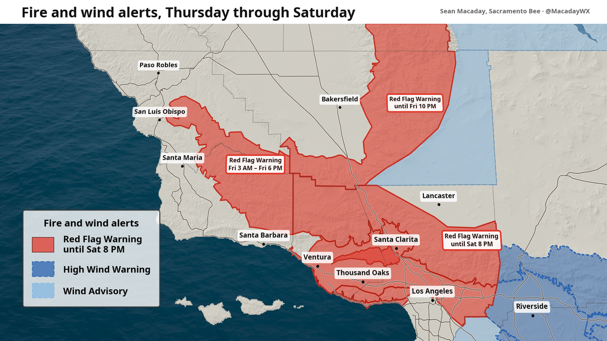
As a strong Santa Ana wind event continues to strengthen across Southern California Friday, all eyes are to any fires that could spark or continue spreading. A series of red-flag warnings continued Friday across…
- Wind advisory previously issued for Desert Region will expire at 11 a.m.
San Luis Obispo Tribune The creation of this content included the use of AI based on templates created, reviewed and edited by journalists in the newsroom. Read more on our AI policy here. The advisory had been issued…
- UPDATE: Red flag warning for North Bay Interior Mountains predicted to expire at 11 a.m.
San Luis Obispo Tribune The creation of this content included the use of AI based on templates created, reviewed and edited by journalists in the newsroom. Read more on our AI policy here. The warning was for North Bay…
-
 Wind, cooldown and rain? What to expect this weekend and beyond in NorCal weather
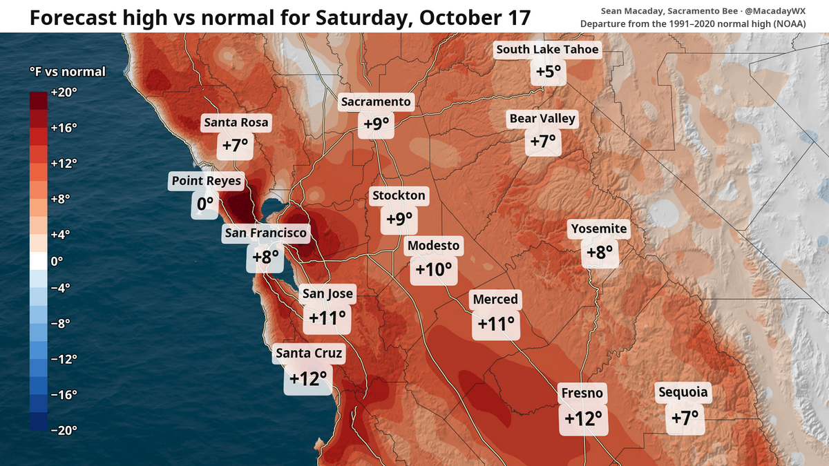
Despite a breeze, this weekend is set to be the warmest stretch for the foreseeable future. Those factors will provide some fire risk before temperatures tumble and a window for rain opens next week. It’s a great…
-
 El Niño-powered Kelvin wave raising sea level and concerns along Central Coast
BAYWOOD PARK, Calif. (KEYT) - Waves are crashing higher along the San Luis Obispo County coastline, with water levels on the San Luis Obispo County North Coast measuring more than a foot above expected levels. The…
Air quality
Forecast
- SatGood
- SunGood
- MonGood
San Luis Obispo, CA reporting area. Data from AirNow (EPA and its state, local and tribal partners); preliminary and subject to change.
Sun & moon
Almanac
MonthlySan Luis Obispo Poly, records since 1927. Normals 1991–2020. Data from NOAA's Regional Climate Centers (ACIS).
Nearby
- Santa Maria 40 km
- Atascadero 25 km
- Orcutt 48 km
- Paso Robles 41 km
- Arroyo Grande 17 km
- Nipomo 29 km
- Los Osos 17 km
- Grover Beach 16 km
- Morro Bay 21 km
- Pismo Beach 13 km
- Templeton 32 km
- Guadalupe 33 km
Forecasters' discussion
From the National Weather Service office in LOX, issued 3 hrs ago
Synopsis
24/329 AM.
Weak northeast winds are expected to develop this weekend, bringing drier conditions and warmer temperatures to the region that will persist through the first half of next week. Cooler conditions to follow with a growing potential for a significant storm system towards the end of next week.
Long Term (tue-fri)
24/341 AM.
Northwest to northeast winds will increase Monday Night into Tuesday, then weaken into Wednesday. This will keep temperatures largely unchanged with highs in the 70s to lower 80s most common which is right around normal for this time of the year.
The pattern will start to change around Thursday, with onshore flow returning, temperatures dropping, and low pressure forming over the West Coast. This will open the storm window over California, with a growing chance of a significant storm impacting the local area as early as Friday but more so for the weekend. There is a 90+% chance for rain sometime in the Oct 30 through Nov 2 timeframe, likely lasting several hours. Halloween activities are likely to be impacted. There remains a range of outcomes in terms of rain amounts, rates, and winds. At this point, the most likely outcome is for a moderate- level storm in terms of strength and impacts, with a low but present risk for a higher level storm.
Aviation
24/1041Z.
At 10Z over KLAX, there was no marine layer and no inversion.
High confidence in VFR conditions at all TAF sites through at least 12Z Sunday, except a 20% chance of IFR ceilings Sunday morning at KLAX KLGB KSMX. Light LLWS possible at KVNY KBUR KCMA with NE winds aloft this morning.
KLAX...High confidence in VFR conditions through at least 18Z Sunday, except for a 20% chance of IFR ceilings Sunday 10-16Z. High confidence in any east winds staying under 08 knots.
KBUR...High confidence in VFR conditions through at least Sunday. North winds 5-10 knots and/or LLWS +/- 10 knots possible through 18Z today.
Marine
24/248 AM.
Steep seas near 10 feet will continue through early this morning for the outer waters. 15-20 knot North winds are likely nearshore this morning around Malibu, and West winds over many nearshore waters in the afternoon hours. Otherwise, high confidence in quiet conditions this weekend. Northwest winds will increase next week. SCA conditions are likely Monday and Tuesday for the waters from the Central Coast through San Nicolas Island.
Forecasts, observations and alerts in the United States come from the National Weather Service (NOAA); radar from NOAA's Multi-Radar Multi-Sensor system; satellite imagery from NASA's Global Imagery Browse Services (GIBS) and NOAA's GOES satellites; the map from the U.S. Geological Survey's National Map; air quality from AirNow (EPA and its partners); hurricane information from the National Hurricane Center; climate normals and records from NOAA's Regional Climate Centers (ACIS). Forecasts outside the United States and the UV index: MET Norway (CC BY 4.0); observations outside the U.S.: airport reports via NOAA's Aviation Weather Center. Place names: GeoNames (CC BY 4.0). Data are copied on a schedule and may lag the sources; for warnings that affect your safety, follow your local National Weather Service office and emergency officials. Weather news is drawn from the 4Search index and reflects what the press published. Terms of use.