Install
Glendale, AZ 85312 Weather
Current conditions
Observed at Glendale, Glendale Municipal Airport · 1 hr ago
Forecast
10-day-
Today
A chance of showers and thunderstorms before 5pm, then showers and thunderstorms likely. Mostly cloudy. High near 86, with temperatures falling to around 78 in the afternoon. East southeast wind 5 to 10 mph. Chance of precipitation is 60%. New rainfall amounts between a tenth and quarter of an inch possible.
-
Tonight
Showers and thunderstorms likely before 7pm, then a chance of showers and thunderstorms between 7pm and 1am, then showers and thunderstorms. Mostly cloudy, with a low around 71. North wind around 5 mph. Chance of precipitation is 80%. New rainfall amounts between a quarter and half of an inch possible.
-
Thursday
Showers and thunderstorms likely before 8am, then a chance of showers and thunderstorms between 8am and 9am, then showers and thunderstorms likely between 9am and 10am, then a chance of showers and thunderstorms between 10am and 2pm, then a chance of showers and thunderstorms between 2pm and 3pm, then a slight chance of showers and thunderstorms. Partly sunny. High near 82, with temperatures falling to around 79 in the afternoon. Southwest wind 5 to 10 mph, with gusts as high as 20 mph. Chance of precipitation is 70%. New rainfall amounts between a tenth and quarter of an inch possible.
National Weather Service forecast updated 1 hr ago.
Hourly
Hourly forecast- Now81°50%
- 1 PM84°54%
- 2 PM81°47%
- 3 PM81°40%
- 4 PM80°45%
- 5 PM78°55%
- 6 PM77°58%
- 7 PM76°50%
- 8 PM76°41%
- 9 PM75°41%
- 10 PM75°48%
- 11 PM74°51%
- Thu12 AM74°53%
- 1 AM73°61%
- 2 AM73°66%
- 3 AM72°75%
- 4 AM72°70%
- 5 AM72°65%
- 6 AM71°65%
- 7 AM71°69%
- 8 AM73°54%
- 9 AM75°58%
- 10 AM77°47%
- 11 AM78°32%
Daily forecast
Details- TodayOct 21Chance Showers And Thunderstorms75%71°86°
- ThuOct 22Showers And Thunderstorms Likely then Chance Showers And Thunderstorms69%64°82°
- FriOct 23Sunny61°78°
- SatOct 24Sunny60°77°
- SunOct 25Sunny61°80°
- MonOct 26Sunny62°83°
- TueOct 27Sunny63°84°
- WedOct 28Cloudy61°86°
- ThuOct 29Cloudy61°87°
Days after the National Weather Service's seven are MET Norway's outlook, a computer model with no forecaster's review.
Radar
Full mapWeather news near Glendale
More weather news-
 Could a tornado hit Phoenix this week? Here’s what we’re watching.
There’s a relatively rare severe-weather risk on Wednesday in parts of Arizona and Southern California. The National Weather Service Storm Prediction Center has outlined a marginal (Level 1 out of 5) risk in an area…
-
 Dry Tuesday in Phoenix leads into rainy days
AZ Family Dry Tuesday in Phoenix leads into rainy days Trump signs act making new national park in southern Arizona One year after Tia Colelay was last heard from, what happens next? Suns’ Oso Ighodaro embraces hometown…
-
 MOST ACCURATE FORECAST: Flood Watches across Arizona, strong to severe storms possible
PHOENIX — A powerful fall storm is moving into Arizona. It already gave us a preview. A severe storm dropped large hail from Chandler to Mesa Tuesday night. Winds will pick up, temperatures will drop and strong to…
- Severe weather chances increase in Arizona, with hail, tornado risks
Forecasts for the storms coming to Arizona have taken a more severe turn ahead of their arrival on Wednesday, Oct. 21. Recent updates from the Storm Prediction Center increased the threat level in the state up to an…
-
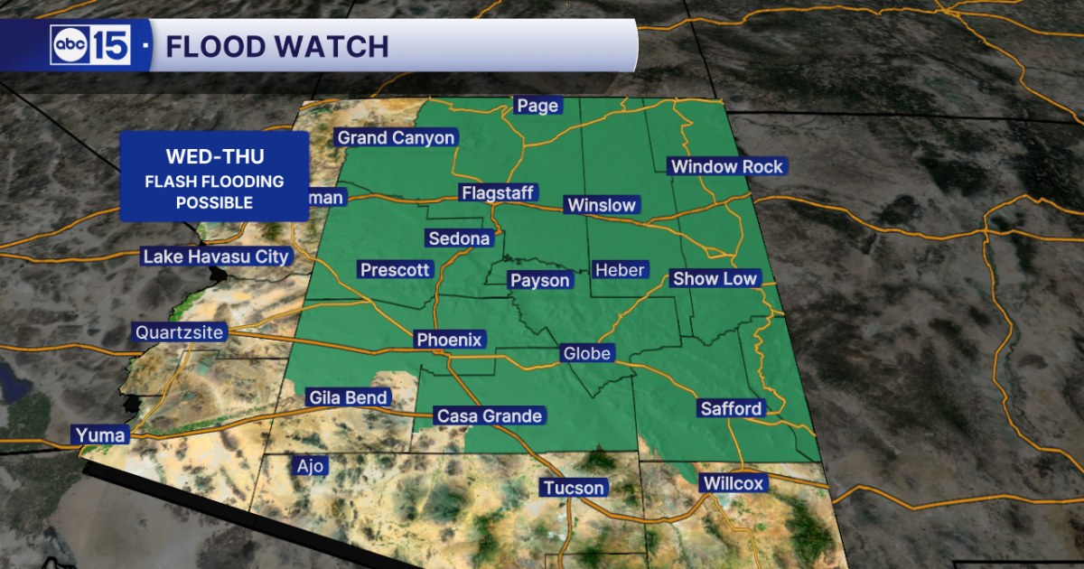 WHAT TO EXPECT: Heavy rain and flash flooding possible across Arizona midweek
Get ready for big weather changes across the state this week! A strong storm system off the California coast is pulling well-above-normal moisture into Arizona. The setup will fuel showers and thunderstorms across the…
-
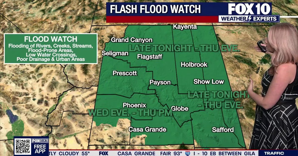 Arizona weather forecast: Heavy rain and severe storms approaching
The National Weather Service has issued flood watches across Arizona as heavy rain and severe storms are set to move into the region. PHOENIX - Plenty of change is expected over the next several days. What to Expect…
-
 Strong storm system headed to Arizona — here's when it'll hit
AZ Family Strong storm system headed to Arizona — here's when it'll hit How much rain could Phoenix get? Here’s the latest forecast Heavy rain, strong storms across Phoenix area expected later this week Sunny, warm…
-
 Foreign leaders endorse Miami Republican, sparking interference claims
There’s a relatively rare severe-weather risk on Wednesday in parts of Arizona and Southern California. The National Weather Service Storm Prediction Center has outlined a marginal (Level 1 out of 5) risk in an area…
-
 MOST ACCURATE FORECAST: Flood Watch issued as storm system heads to Arizona
PHOENIX — It’s a warm start to the week in the Valley! Phoenix topped out in the low 90s on Monday and we’ll do it again on Tuesday. We are tracking another storm system on the way that will drop temperatures for the…
-
 Trump confirms U.S. seeking return of retired teacher held in Russia
There’s a relatively rare severe-weather risk on Wednesday in parts of Arizona and Southern California. The National Weather Service Storm Prediction Center has outlined a marginal (Level 1 out of 5) risk in an area…
Air quality
Acceptable. Unusually sensitive people should consider limiting prolonged outdoor exertion.
Forecast
- WedGood (45)
- ThuGood (36)
- FriGood (42)
Phoenix, AZ reporting area · 1 hr ago. Data from AirNow (EPA and its state, local and tribal partners); preliminary and subject to change.
Sun & moon
Almanac
MonthlyPhoenix Area, records since 1895. Normals 1991–2020. Data from NOAA's Regional Climate Centers (ACIS).
Nearby
Forecasters' discussion
From the National Weather Service office in PSR, issued 7 hrs ago
Update
Updated 12Z Aviation Discussion.
Key Messages
- A strong low pressure system is expected to bring multiple rounds of showers and thunderstorms through Thursday across much of central and eastern Arizona.
- Moderate to heavy rainfall activity leading to areas of flash flooding as well as isolated to widely scattered strong to severe thunderstorms leading to damaging wind gusts, large hail, and even a few isolated tornadoes are all possible.
- Drier air filtering into the region by the end of the week will lead to more benign weather conditions during the weekend through at least early next week.
- Near normal temperatures today will cool to below normal levels by the latter half of the week and last through the weekend.
Aviation
Updated at 1203Z.
South Central Arizona including KPHX, KIWA, KSDL, and KDVT: Rounds of isolated to scattered strong thunderstorms with heavy rain leading to sub-VFR VIS, brief strong and erratic wind gusts, isolated large hail, and low CIGs will be possible today through at least Thursday morning. Confidence in timing out best chances RA/TS is moderate, as isolated RA/TS may develop at any time. An increase in activity is expected going into this afternoon and then there may be a break this evening/early tonight before another round develops later tonight-Thursday morning. A downtrend in activity is expected by Thursday evening. Winds will favor a light easterly component through most of the TAF period, with periods of southerly winds during showers and storms. Lowest CIGs today are expected around 5-7K ft AGL and then may dip to 3-5K ft Thursday morning with showers and storms.
Southeast California/Southwest Arizona including KIPL and KBLH: No major aviation concerns are expected during the TAF period. Outside of extended periods of VRB conditions, S'rly flow will be favored at KBLH, with some gusts upwards of 20-25 kt during the afternoon hours, while winds at KIPL will take on familiar diurnal trends, flipping between SE and W. FEW-SCT skies will be common through Wednesday evening, with the lowest bases around 6-7 kft.
Fire Weather
A low pressure system will bring very active weather conditions across much of central and eastern AZ through Thursday as multiple rounds of showers and thunderstorms are expected. Significant rainfall activity is likely in some areas, particularly across the higher terrain areas of the eastern districts where rainfall amounts in excess of 1-2" are possible. MinRHs through Thursday will range between 30-40% across the western districts and between 40-70% across the eastern districts along with good to excellent overnight recoveries. Some gusty winds with peak gusts upwards of 25-30 mph are likely this afternoon and once again on Thursday across the western districts. Much quieter conditions are expected starting Friday along with a decrease in humidity values. Near normal temperatures today will cool into a below normal category starting Thursday and lasting through the weekend.
Forecasts, observations and alerts in the United States come from the National Weather Service (NOAA); radar from NOAA's Multi-Radar Multi-Sensor system; satellite imagery from NASA's Global Imagery Browse Services (GIBS) and NOAA's GOES satellites; the map from the U.S. Geological Survey's National Map; air quality from AirNow (EPA and its partners); hurricane information from the National Hurricane Center; climate normals and records from NOAA's Regional Climate Centers (ACIS). Forecasts outside the United States and the UV index: MET Norway (CC BY 4.0); observations outside the U.S.: airport reports via NOAA's Aviation Weather Center. Place names: GeoNames (CC BY 4.0). Data are copied on a schedule and may lag the sources; for warnings that affect your safety, follow your local National Weather Service office and emergency officials. Weather news is drawn from the 4Search index and reflects what the press published. Terms of use.