Install
Pleasant Hill, IA 50327 Weather
Current conditions
Observed at Ankeny Regional Airport · 1 hr ago
Forecast
10-day-
Friday
Sunny, with a high near 76. South southeast wind 5 to 13 mph, with gusts as high as 21 mph.
-
Friday Night
Partly cloudy, with a low around 58. South southeast wind around 10 mph, with gusts as high as 18 mph.
-
Saturday
Mostly sunny, with a high near 76. South wind around 12 mph.
National Weather Service forecast updated 19 hrs ago.
Hourly
Hourly forecast- Now54°
- 8 AM54°
- 9 AM57°
- 10 AM63°
- 11 AM67°
- 12 PM71°
- 1 PM73°
- 2 PM75°
- 3 PM76°
- 4 PM76°
- 5 PM75°
- 6 PM73°
- 7 PM70°
- 8 PM66°
- 9 PM64°
- 10 PM64°
- 11 PM63°
- Sat12 AM62°
- 1 AM61°
- 2 AM60°
- 3 AM59°
- 4 AM59°
- 5 AM58°
- 6 AM58°
10-day forecast
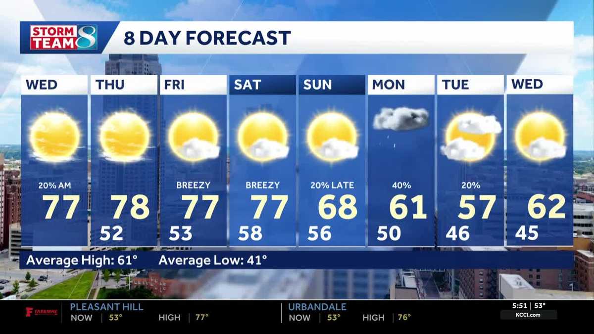
Details- ThuOct 22Sunny53°78°
- TodayOct 23Sunny58°76°
- SatOct 24Mostly Sunny56°76°
- SunOct 25Partly Sunny53°74°
- MonOct 26Chance Rain Showers32%47°66°
- TueOct 27Chance Rain Showers27%45°59°
- WedOct 28Slight Chance Rain Showers17%46°62°
- ThuOct 29Partly cloudy36°50°
- FriOct 30Sunny32°53°
- SatOct 31Cloudy44°63°
Days after the National Weather Service's seven are MET Norway's outlook, a computer model with no forecaster's review.
Radar
Full mapWeather news near Pleasant Hill
More weather news-
 Dangerous Freeze Warnings Issued for Iowa, Wisconsin, Minnesota and Illinois as Temperatures Drop
Freeze Warnings take effect early Saturday across much of Iowa, Wisconsin, southeast and central Minnesota and northern Illinois, with lows as cold as 26 degrees expected. Seven National Weather Service offices issued…
- Freeze Warning Issued For Wapello County
A freeze warning has been issued for Wapello County, including Ottumwa, for early Saturday morning. The National Weather Service says temperatures could drop as low as 31 degrees, with the warning in effect from 1 a.m…
-
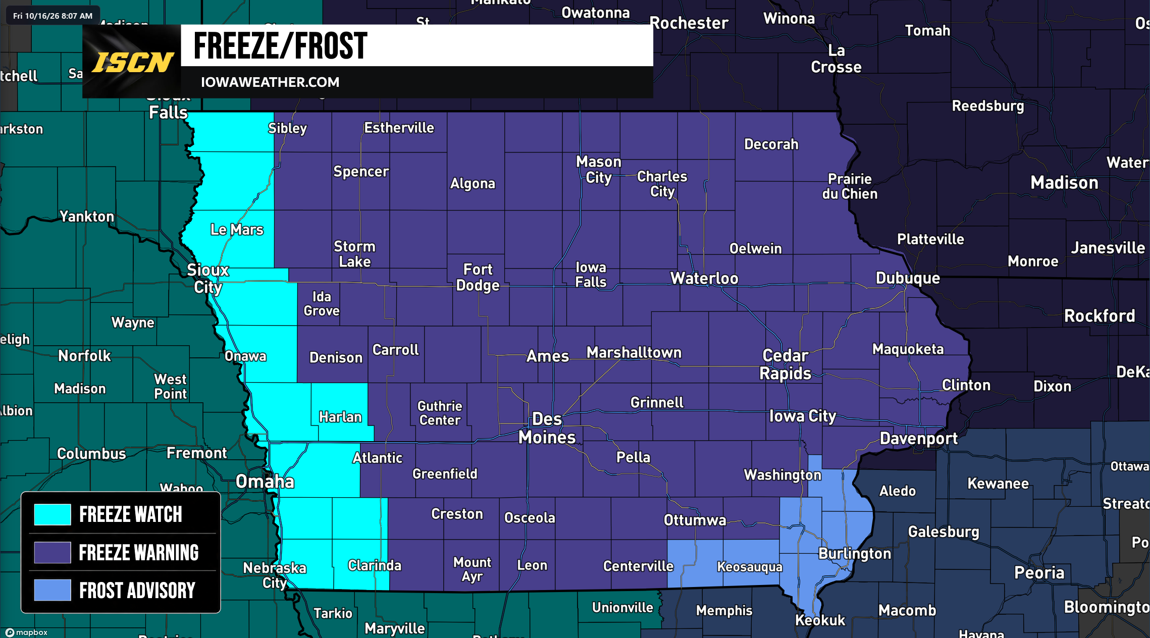 Widespread Freeze Warnings Issued Across Iowa as Temperatures Could Drop Into the 20s Saturday Morning
A widespread round of freezing temperatures is expected across Iowa early Saturday morning, prompting the National Weather Service to issue Freeze Warnings, Freeze Watches, and Frost Advisories for the entire state…
-
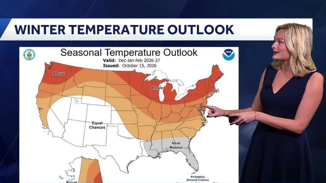 Looking ahead: Iowa's winter weather outlook
Our first frost of the season is already on the way, but what will be in store for the upcoming winter months? This Thursday the National Oceanic and Atmospheric Administration (NOAA) released its winter outlook with…
-
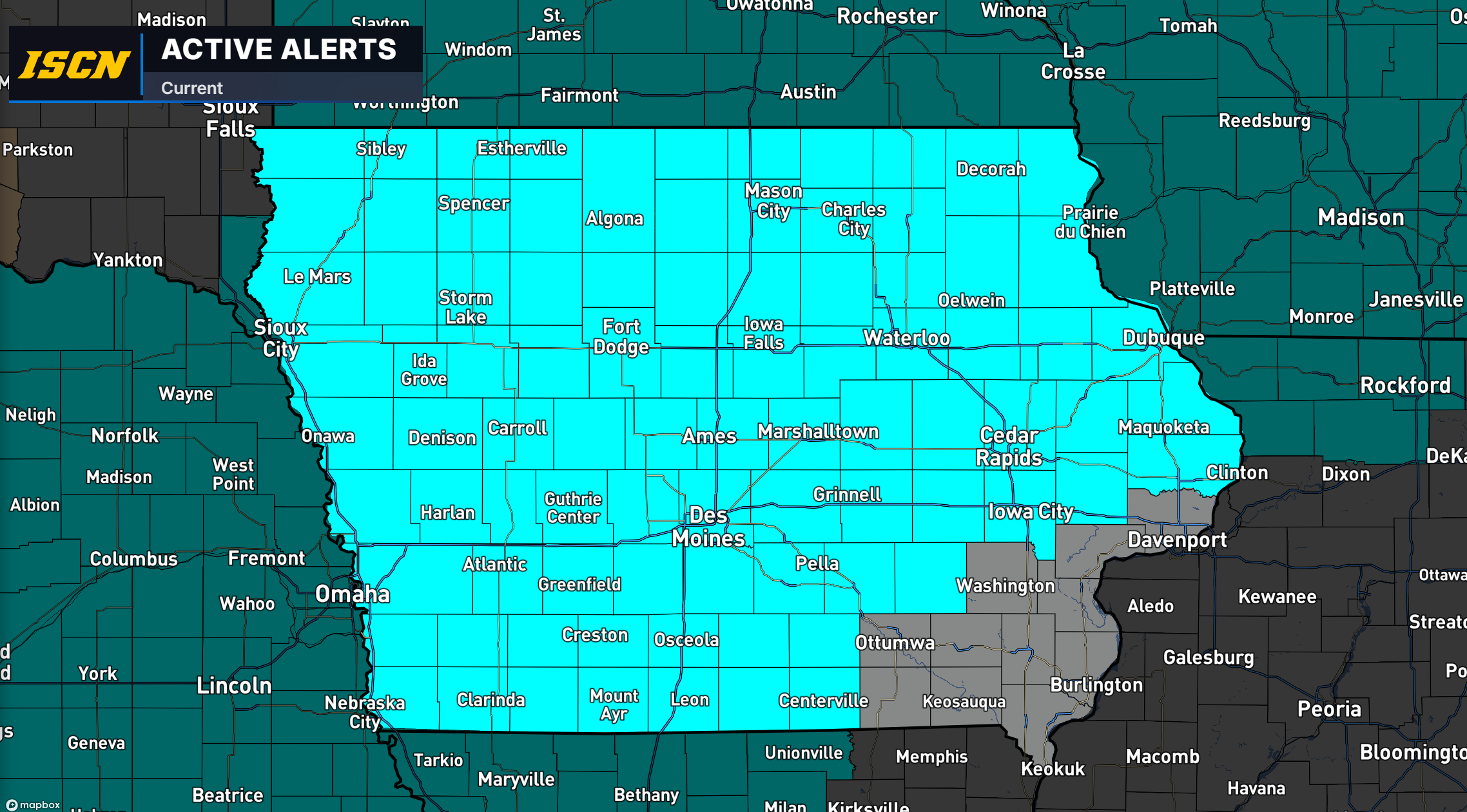 Freeze Watch Issued for Much of Iowa as Temperatures Could Drop Into the 20s Saturday Morning
Much of Iowa could experience a widespread freeze this weekend as colder air moves into the region, bringing some of the lowest temperatures of the fall season. The National Weather Service has issued a Freeze Watch for…
-
 More than a wet month: A review of September’s rainfall effects on Iowa farmers
Rain, rain and more rain. That’s what this September has looked like for Iowans. This affects everyone, from students walking to class through the rain to the local farmers waiting to harvest their crops. We have seen a…
-
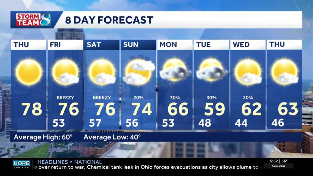 Iowa weather: Warm days continue into the weekend
We will continue to enjoy sunny weather for the rest of the week. Today is no exception, with highs in the mid- to upper-70s and south winds around 5 to 10 mph. A light layer may still be warranted for some of us, with…
-
 Corn and Soybean Harvest Behind Schedule in Iowa, First Frost of Season Seen
Corn and soybean harvest is behind schedule in Iowa. Ninety-eight percent of corn has reached maturity, which is even with the five-year average. Twenty-six percent of corn has been harvested, which is 24 percentage…
-
 Iowa weather: Warm, dry conditions will come to an end next week
Clouds will linger a bit this morning, but most of the state will stay dry. Interactive Radar | Weather Alerts | Skycams There have been a few showers early this morning to the south and west, but the moisture is…
-
 Warm and dry weather pattern holds across Iowa
KWWL Unseasonably warm and dry conditions will continue tonight across Waterloo and much of Iowa. Patchy morning fog is possible, with a chance of rain returning this weekend.
Air quality
Acceptable. Unusually sensitive people should consider limiting prolonged outdoor exertion.
Forecast
- FriModerate
- SatModerate
Des Moines, IA reporting area · 1 hr ago. Data from AirNow (EPA and its state, local and tribal partners); preliminary and subject to change.
Sun & moon
Almanac
MonthlyDes Moines Area, records since 1878. Normals 1991–2020. Data from NOAA's Regional Climate Centers (ACIS).
Nearby
Forecasters' discussion
From the National Weather Service office in DMX, issued 5 hrs ago
Key Messages
- Warm, dry, and breezy today with highs in the mid to upper 70s and winds gusting 25-30 mph across northern and western Iowa.
- Warmer weather continues on Saturday. A slow moving cold front will bring cooler temperatures in the upper 50s to low 60s across northern Iowa on Sunday while the rest of the state continues to see mid 70s.
- Rain chances and relatively cooler temperatures return early next week, around Monday into Tuesday.
Short Term
Issued at 207 AM CDT Fri Oct 23 2026
Clear skies are in place across eastern and central Iowa early this morning while an area of cloud cover is across western Iowa. This cloud cover is associated with an area of convergence and weak moisture plume on the eastern edge of the western US trough that will continue to deepen as it slowly pushes into the plains today. Meanwhile in the clearer areas to the east patchy fog is developing in valleys and is notable on satellite, mainly in far NE Iowa into southern Minnesota and Wisconsin. As the western US trough deepens today the pressure gradient across western Iowa increases with a 40+ kt 850mb jet setting up across the plains. Dry low levels will allow for modest mixing, and while we won't tap the strongest winds, gusts of 25-30 mph will be possible across northern and western Iowa through this afternoon. With warm temperatures this afternoon in the mid to upper 70s and relative humidity falling to around 35-45%, the breezy conditions in northern and western Iowa will result in heightened fire weather concerns for those areas. This is primarily an agricultural concern with cured crops, whereas grasses remain fairly green thanks in part to the wet September.
By Saturday the western US trough is expected to deepen into a cutoff low across the southwest US, helping to ease the pressure gradient across the plains and resulting in less breezy conditions. The cold front gets hung up across South Dakota and Nebraska, keeping Iowa dry with temperatures in the mid to upper 70s once again.
Long Term
Issued at 207 AM CDT Fri Oct 23 2026
By Sunday the cold front begins to slip in far northern Iowa with highs there in the upper 50s to low 60s on Sunday. Meanwhile most of Iowa will be in the mid 70s once again on Sunday. A few isolated showers are possible in northern Iowa on Sunday, however dry air will mitigate most development. As the cutoff low across the southwest US finally lifts into the midwest Monday into Tuesday moisture increases and will allow for spotty showers across the area. The cool front finally sinks across the area bringing temperatures down into the 60s. There will be a brief respite with weak mid-level ridging before the stronger trough from the Pacific Northwest swings through our region in the middle to end of next week. That system will push a stronger surface trough through and sweep out most remaining moisture from the earlier systems, bringing quieter autumn weather for at least a couple of days afterward in the extended forecast.
Aviation
Issued at 1037 PM CDT Thu Oct 22 2026
Confidence remains high in VFR conditions through the period at the terminals. While far insufficient to warrant any mention beyond here, there could be isolated fog in the Cedar or Winnebago River Valley Friday around sunrise. Otherwise, winds from a southerly direction will increase through the morning reaching their peak in the afternoon. Sustained winds over 12 knots and gusts of 20 to around 30 knots during this period will be common west of a MCW-DSM-LWD line with winds loosing some strength into Friday evening statewide.
Forecasts, observations and alerts in the United States come from the National Weather Service (NOAA); radar from NOAA's Multi-Radar Multi-Sensor system; satellite imagery from NASA's Global Imagery Browse Services (GIBS) and NOAA's GOES satellites; the map from the U.S. Geological Survey's National Map; air quality from AirNow (EPA and its partners); hurricane information from the National Hurricane Center; climate normals and records from NOAA's Regional Climate Centers (ACIS). Forecasts outside the United States and the UV index: MET Norway (CC BY 4.0); observations outside the U.S.: airport reports via NOAA's Aviation Weather Center. Place names: GeoNames (CC BY 4.0). Data are copied on a schedule and may lag the sources; for warnings that affect your safety, follow your local National Weather Service office and emergency officials. Weather news is drawn from the 4Search index and reflects what the press published. Terms of use.