Install
Pittsboro, IN 46167 Weather
Current conditions
Observed at Indianapolis, Eagle Creek Airpark · 32 min ago
Forecast
10-day-
Tonight
Clear, with a low around 45. North northeast wind around 2 mph.
-
Thursday
Sunny, with a high near 71. North northeast wind 0 to 6 mph.
-
Thursday Night
Clear. Low around 44, with temperatures rising to around 46 overnight. East northeast wind 1 to 6 mph.
National Weather Service forecast updated 3 hrs ago.
Hourly
Hourly forecast- Now52°
- 1 AM51°
- 2 AM49°
- 3 AM48°
- 4 AM47°
- 5 AM46°
- 6 AM46°
- 7 AM46°
- 8 AM45°
- 9 AM48°
- 10 AM56°
- 11 AM62°
- 12 PM65°
- 1 PM68°
- 2 PM70°
- 3 PM70°
- 4 PM71°
- 5 PM71°
- 6 PM69°
- 7 PM66°
- 8 PM62°
- 9 PM57°
- 10 PM54°
- 11 PM53°
10-day forecast
Details- TonightOct 21Clear45°
- TodayOct 22Sunny44°71°
- FriOct 23Sunny45°70°
- SatOct 24Sunny44°69°
- SunOct 25Mostly Sunny47°73°
- MonOct 26Mostly Sunny47°73°
- TueOct 27Partly Sunny45°67°
- WedOct 28Partly Sunny66°
- ThuOct 29Partly cloudy39°60°
- FriOct 30Cloudy46°61°
Days after the National Weather Service's seven are MET Norway's outlook, a computer model with no forecaster's review.
Radar
Full mapWeather news near Pittsboro
More weather news-
 Quiet pattern settles in | Oct. 19, 2026
WRTV 6 (ABC) is Indianapolis' first television station, delivering trusted local news, weather, traffic, investigations, and community coverage across broadcast, digital, and connected platforms. WRTV serves Central…
-
 Fall weather pattern continues this week | Oct 20, 2026
WRTV INDIANAPOLIS (WRTV) – A beautiful fall weather pattern will stick around for the next week. Typical fall like pattern with crisp morning lows and warmer afternoons. TODAY: We will see a terrific Tuesday with lots…
-
 Thanksgiving Week Weather Forecast 2026: Old Farmer's Almanac Map Reveals Where Snow Could Fall
The Thanksgiving Week Weather Forecast 2026 from The Old Farmer's Almanac identifies six regions where snow could fall during the holiday period, the Northeast, Atlantic Corridor, Appalachians, Lower Lakes, Upper…
-
 Warming Trend Arrives Across Central Indiana This Week
A warming trend is taking hold today, with temperatures rising steadily over the coming days. The 13Weather Blog breaks down how the change will shape conditions across the Indianapolis area. Expect milder afternoons…
-
 Frost advisory issued for Fishers area early Monday
Fishers residents with tender plants still outdoors may want to cover them tonight. The National Weather Service in Indianapolis has issued a frost advisory for much of central Indiana, including Hamilton County, from 2…
-
 Dangerous Freeze Warnings for 38 Counties in Indiana as Temperatures Plummet
Freeze Warnings are in effect for 38 counties in Indiana from early Sunday morning, with lows as cold as 30 degrees expected. The warnings cover central, northern, east central and southeast Indiana. Three National…
-
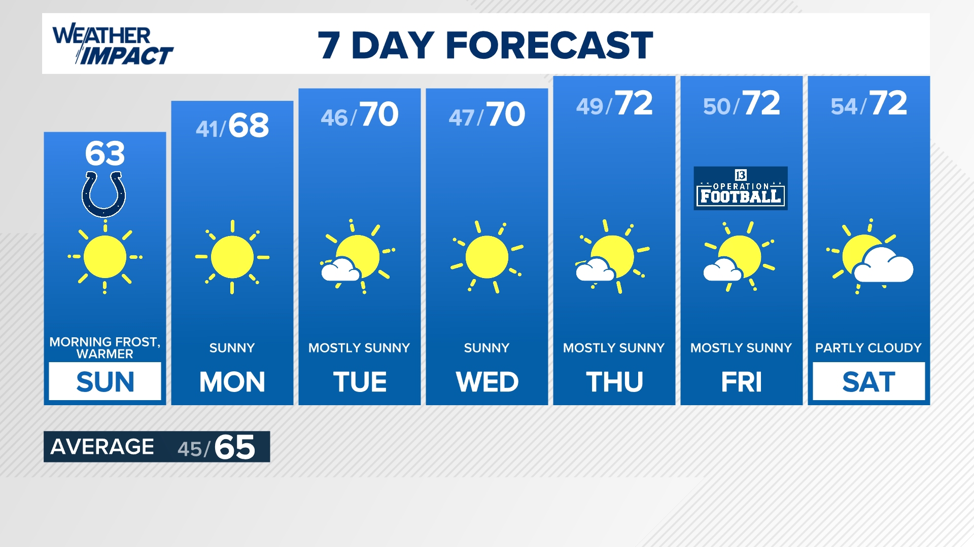 Warming trend from here | 13Weather Blog
INDIANAPOLIS — A stretch of sunny, warmer days is on the horizon with daytime high temperatures likely to be above average throughout the extended forecast. A high pressure system that brought the return of sunshine…
- Indy Wakes to Frost, Heads for Sunny 70s All Week
Residents with tender outdoor plants should cover them before the advisory ends, since frost could damage sensitive vegetation. After the chilly start, south-southeast winds will stay light at 2 to 6 mph, with no rain…
-
 First Frost & Freeze of the season | Oct. 17, 2026
WRTV First Frost & Freeze of the season | Oct. 17, 2026 INDIANAPOLIS (WRTV) – Following a gloomy and chilly start to the weekend, the sunshine has returned with the first widespread risk of frost and freeze of the…
-
 Cool afternoon with frost & freeze conditions expected tonight
INDIANAPOLIS- Cool and crisp this morning but a nice afternoon is in store. Our first frost and freeze of the season is expected tonight. TODAY: Temperatures are in the 30s to around 40 to start the weekend and the…
Air quality
Everyone should reduce prolonged or heavy exertion; sensitive groups should avoid it.
Forecast
- ThuModerate
Indianapolis, IN reporting area · 1 hr ago. Data from AirNow (EPA and its state, local and tribal partners); preliminary and subject to change.
Sun & moon
Almanac
MonthlyIndianapolis Area, records since 1871. Normals 1991–2020. Data from NOAA's Regional Climate Centers (ACIS).
Nearby
- Indianapolis 28 km
- Carmel 32 km
- Fishers 40 km
- Noblesville 44 km
- Greenwood 41 km
- Lawrence 38 km
- Westfield 35 km
- Plainfield 18 km
- Zionsville 20 km
- Brownsburg 6 km
- Franklin 55 km
- Greenfield 60 km
Forecasters' discussion
From the National Weather Service office in IND, issued 3 hrs ago
Key Messages
- Dry yet pleasant fall weather will prevail through this weekend
- Daytime lows will be near normal with above normal highs through the period.
- Very small chances of rain next Tuesday, better chances late next week.
Forecast Update
Issued at 909 PM EDT Wed Oct 21 2026
Surface analysis late this evening shows strong high pressure stretching from the eastern Great Lakes across Indiana and Illinois to MO and Arkansas. GOES19 shows mostly clear skies across the state and winds were light to calm with dew points mainly in the 40s.
Aloft, strong ridging was in place across the Plains, extending north into Canada. This was providing NW flow aloft over Indiana and water vapor shows subsidence across the region.
Overall, another quiet and cool night will be in store as good radiational cooling conditions exist. Look for the clear skies to continue as lows fall into the 40s. HRRR fails to suggest much in the way of fog development. This still cannot be ruled out however due to expected low dew point depressions and calm winds. Ongoing forecast remains in good shape.
Ind Watches
None.
Forecasts, observations and alerts in the United States come from the National Weather Service (NOAA); radar from NOAA's Multi-Radar Multi-Sensor system; satellite imagery from NASA's Global Imagery Browse Services (GIBS) and NOAA's GOES satellites; the map from the U.S. Geological Survey's National Map; air quality from AirNow (EPA and its partners); hurricane information from the National Hurricane Center; climate normals and records from NOAA's Regional Climate Centers (ACIS). Forecasts outside the United States and the UV index: MET Norway (CC BY 4.0); observations outside the U.S.: airport reports via NOAA's Aviation Weather Center. Place names: GeoNames (CC BY 4.0). Data are copied on a schedule and may lag the sources; for warnings that affect your safety, follow your local National Weather Service office and emergency officials. Weather news is drawn from the 4Search index and reflects what the press published. Terms of use.