Install
Chattanooga, TN 37421 Weather
Current conditions
Observed at Chattanooga, Lovell Field · 49 min ago
Forecast
10-day-
Today
Sunny, with a high near 74. Northwest wind 0 to 5 mph.
-
Tonight
Clear. Low around 47, with temperatures rising to around 50 overnight. Northeast wind 0 to 5 mph.
-
Thursday
Sunny, with a high near 73. Northeast wind 5 to 10 mph, with gusts as high as 20 mph.
National Weather Service forecast updated 9 hrs ago.
Hourly
Hourly forecast- Now60°
- 12 PM64°
- 1 PM68°
- 2 PM72°
- 3 PM73°
- 4 PM74°
- 5 PM74°
- 6 PM72°
- 7 PM68°
- 8 PM64°
- 9 PM60°
- 10 PM58°
- 11 PM56°
- Thu12 AM55°
- 1 AM53°
- 2 AM52°
- 3 AM51°
- 4 AM51°
- 5 AM50°
- 6 AM49°
- 7 AM48°
- 8 AM47°
- 9 AM50°
- 10 AM56°
Daily forecast
Details- TodayOct 21Sunny47°74°
- ThuOct 22Sunny47°73°
- FriOct 23Sunny46°74°
- SatOct 24Sunny43°70°
- SunOct 25Sunny44°70°
- MonOct 26Sunny47°72°
- TueOct 27Mostly Sunny49°74°
- WedOct 28Partly cloudy55°74°
- ThuOct 29Mostly sunny0.02 in53°69°
Days after the National Weather Service's seven are MET Norway's outlook, a computer model with no forecaster's review.
Radar
Full mapWeather news near Chattanooga
More weather news- Chilly Morning, Patio Afternoons: Knoxville Locked Into Sunny 70s Streak
The National Weather Service expects mostly clear conditions Tuesday night, with temperatures dropping to around 45 degrees. River fog remains possible near waterways Tuesday, October 20, from 5 to 9 a.m. EDT, but the…
- Sunny Streak: Knoxville Basks in 70-Degree Afternoons, Jacket Weather at Dawn
The mild afternoons will come with distinctly chilly mornings and nights. Tonight will drop to around 43 degrees, so early risers may want a jacket even as the afternoon feels comfortably warm. Tuesday and Wednesday…
- Knoxville Swaps Sizzle for Shiver: Frost on Deck, 70s Rebound Next Week
Knoxville woke Saturday to a sharp fall reset: light rain early, temperatures around 52 degrees, and a forecast high only 59 after recent summerlike heat. The rain should fade as the morning wears on, while north winds…
- Knoxville’s Last Taste of Summer Before Frosty Fall Weekend Hits
Knoxville is getting one more warm, mostly sunny day Friday before a sharp fall cooldown settles in for the weekend. Temperatures will climb from the upper 60s early to near 82 degrees, but the summerlike stretch will…
-
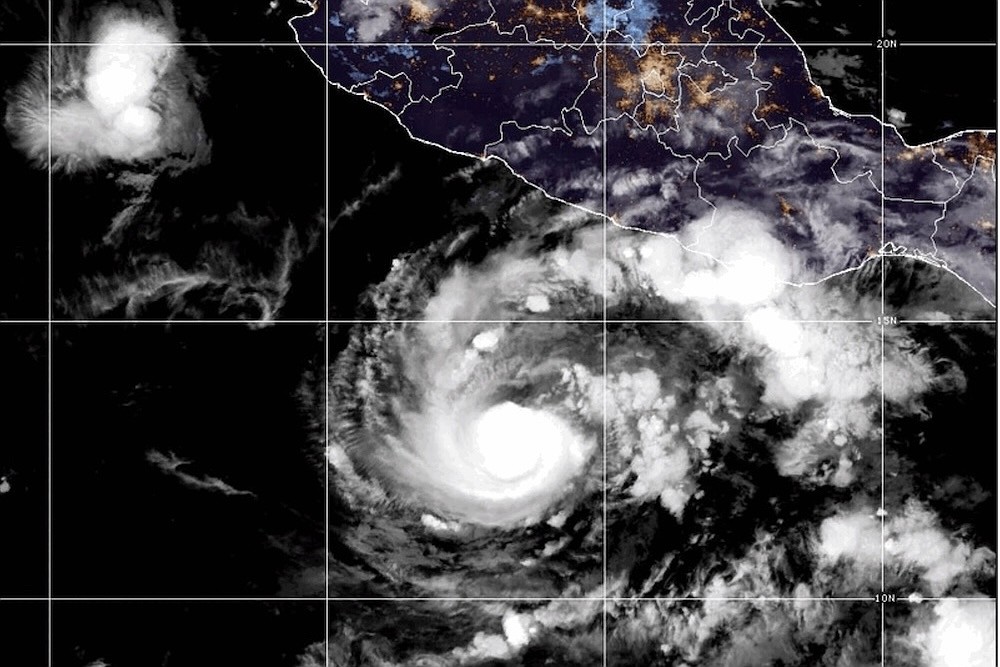 Hurricane Trudy strengthens off Mexico's coast with major storm expected
Chattanooga Times Free Press Hurricane Trudy strengthens off Mexico's coast with major storm expected Trudy was located about 230 miles (370 kilometers) southwest of Acapulco, Mexico, with maximum sustained winds of 105…
-
 Another day of record heat before a much cooler weekend
Local 3 News Good morning! Another unseasonably hot day is on tap for the Tennessee Valley, with highs climbing into the upper 80s to lower 90s. Chattanooga's daily record high is 85, and it will easily be broken later…
-
 Pasquali’s Pix: Tide to prevail in Neyland for first time since 2020
Chattanooga Times Free Press Pasquali’s Pix: Tide to prevail in Neyland for first time since 2020 It can be amusing every so often to look back at what Southeastern Conference football coaches say at the annual media…
-
 Record highs set Tuesday, Wednesday and forecast for Thursday
Chattanooga Times Free Press Record highs set Tuesday, Wednesday and forecast for Thursday After setting daily record highs of 90 degrees Tuesday and Wednesday, Chattanooga is forecast to notch another record Thursday…
-
 Cold Front Ends Record October Heat Across the United States
Record-breaking October warmth across the central and eastern United States is giving way to a sharp cooldown, with a powerful cold front expected to bring rain, strong winds and scattered temperatures in the 40s by the…
-
 Beautiful Fall weather continues for the Tennessee Valley
WTVC A dry pattern but overall beautiful Fall weather right through early next week Chilly mornings in the 40s with sunny and warm afternoons in the 70s No rain in sight possibly through the end of the month October is…
Air quality
Acceptable. Unusually sensitive people should consider limiting prolonged outdoor exertion.
Forecast
- WedGood (50)
- ThuModerate (51)
Chattanooga, TN reporting area · 1 hr ago. Data from AirNow (EPA and its state, local and tribal partners); preliminary and subject to change.
Sun & moon
Almanac
MonthlyChattanooga Area, records since 1879. Normals 1991–2020. Data from NOAA's Regional Climate Centers (ACIS).
Nearby
- East Chattanooga 10 km
- Cleveland 29 km
- Dalton 33 km
- East Ridge 10 km
- East Brainerd 3 km
- Soddy-Daisy 24 km
- Middle Valley 19 km
- Red Bank 17 km
- Collegedale 9 km
- Fort Oglethorpe 13 km
- Signal Mountain 21 km
- Harrison 10 km
Forecasters' discussion
From the National Weather Service office in MRX, issued 4 hrs ago
Key Messages
Updated at 735 AM EDT Wed Oct 21 2026
- Dry weather dominates the forecast period, with cool mornings and pleasant afternoons each day. Afternoon relative humidity will remain on the lower side as well.
Discussion
Issued at 137 AM EDT Wed Oct 21 2026
Morning fog along rivers and lakes will be possible again during the late night into early morning hours today, as cool air settles over the warm waters.
A large upper ridge to our west will gradually shift eastward during the period and surface high pressure to our north and northeast will extend into our area, keeping our weather dry through next Tuesday. We will see cool nights and pleasant afternoons with high temperatures each day not far either side of seasonal normals. We will also see low relative humidity values during the afternoon hours.
Aviation
(12Z TAFS) Issued at 735 AM EDT Wed Oct 21 2026
VFR with dry weather and light winds to continue.
Preliminary Point Temps
Chattanooga Airport, TN 75 48 74 49 / 0 0 0 0 Knoxville McGhee Tyson Airport, TN 73 44 72 44 / 0 0 0 0 Oak Ridge, TN 74 45 72 45 / 0 0 0 0 Tri Cities Airport, TN 72 38 69 36 / 0 0 0 0
Forecasts, observations and alerts in the United States come from the National Weather Service (NOAA); radar from NOAA's Multi-Radar Multi-Sensor system; satellite imagery from NASA's Global Imagery Browse Services (GIBS) and NOAA's GOES satellites; the map from the U.S. Geological Survey's National Map; air quality from AirNow (EPA and its partners); hurricane information from the National Hurricane Center; climate normals and records from NOAA's Regional Climate Centers (ACIS). Forecasts outside the United States and the UV index: MET Norway (CC BY 4.0); observations outside the U.S.: airport reports via NOAA's Aviation Weather Center. Place names: GeoNames (CC BY 4.0). Data are copied on a schedule and may lag the sources; for warnings that affect your safety, follow your local National Weather Service office and emergency officials. Weather news is drawn from the 4Search index and reflects what the press published. Terms of use.