Install
Alexander City, AL 35010 Weather
Current conditions
Observed at Alexander City, Thomas C Russell Field Airport · 59 min ago
Forecast
10-day-
Tonight
Clear, with a low around 46. North wind around 5 mph.
-
Friday
Sunny, with a high near 76. East wind around 5 mph.
-
Friday Night
Clear, with a low around 44. East wind around 5 mph.
National Weather Service forecast updated 2 hrs ago.
Hourly
Hourly forecast- Now53°
- 1 AM51°
- 2 AM50°
- 3 AM49°
- 4 AM48°
- 5 AM47°
- 6 AM46°
- 7 AM46°
- 8 AM49°
- 9 AM55°
- 10 AM64°
- 11 AM68°
- 12 PM71°
- 1 PM73°
- 2 PM74°
- 3 PM75°
- 4 PM76°
- 5 PM73°
- 6 PM68°
- 7 PM63°
- 8 PM57°
- 9 PM55°
- 10 PM54°
- 11 PM52°
10-day forecast
Details- TonightOct 22Clear46°
- TodayOct 23Sunny44°76°
- SatOct 24Sunny46°71°
- SunOct 25Sunny45°71°
- MonOct 26Sunny43°72°
- TueOct 27Sunny43°74°
- WedOct 28Mostly Sunny45°74°
- ThuOct 29Sunny75°
- FriOct 30Cloudy59°76°
- SatOct 31Light rain0.82 in59°77°
Days after the National Weather Service's seven are MET Norway's outlook, a computer model with no forecaster's review.
Radar
Full mapWeather news in Alabama
More weather news-
 Alabama News Wire Forecast 10-21-2026
The Alabama News Wire
- Could Alabama see perfect Thanksgiving weather? Almanac says yes
Alabama families planning to gather around the Thanksgiving table may have one less thing to worry about this year: the weather. If the Farmers' Almanac's latest forecast holds, the holiday week could bring a welcome…
-
 First Alert Weather: Beautiful fall stretch continues: Mid-70s, sunny and dry across central Alabama
WBRC 6 News BIRMINGHAM, Ala. (WBRC) - The Next 24 Hours: We’re expecting another beautiful fall day across central Alabama, with plenty of sunshine and afternoon temperatures climbing into the mid to upper 70s. Skies…
-
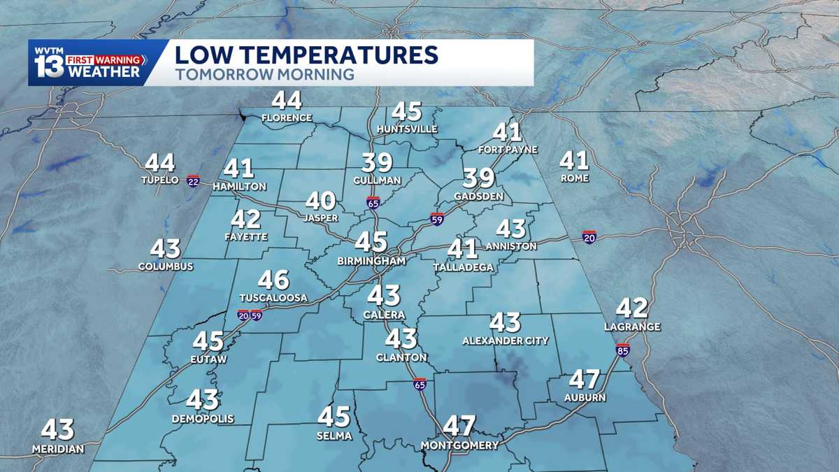 Chilly mornings and sunny, warm days in Alabama's weather forecast this week
MONDAY: Chilly morning lows down in the 40s. Warming up to the 70s with full sunshine in the afternoon. Rain chance: 0%. TUESDAY: Another chilly start in the 40s. Warming to the mid-70s in the afternoon with a light…
-
 Alabama stays rain-free all week as fall warmth builds with low humidity and clear skies
ALABAMA 7 DAY FORECAST Another pleasant fall day is on tap in Alabama as cool and dry conditions persist for another day. An upper-level ridge to our west and a building upper-level trough to our east will keep up in…
-
 Alabama’s first freeze dates: When to expect cold weather in north, central and south Alabama
A few cool fall mornings are usually enough to get Alabama gardeners thinking about their tomatoes, the flowers still blooming, and the potted plants on the porch. How much longer can they stay outside? Across Alabama…
- Colder Air Rolls Into Alabama ...
Published on: October 16, 2026 at 2:26 PM The coolest air so far this season will settle into Alabama for the weekend. Expect highs in the 60s, lows mostly in the 40s, and a sun filled sky both days. NEXT WEEK: Dry…
- Colder air arrives on a north wind making for Alabama's coolest weekend weather forecast in months
SATURDAY: Blustery and cool. Morning lows drop to the upper 40s and lower 50s, and the temperature slowly recovers to the lower and middle 60s in the afternoon with a brisk north wind around 15 to 25 miles per hour with…
-
 Preview of WSFA's weather special: 'Alabama's Second Severe Season'
WSFA Preview of WSFA's weather special: 'Alabama's Second Severe Season' It's Friday Night! Here is a look at your Friday Night Football Fever forecast! It's still warm for now, but cooler air and gusty winds are not…
-
 Fall Temperatures Headed to West Alabama This Weekend
This is the weekend all of Alabama has been waiting for. We’re finally getting a taste of that fall-like weather we’ve been dreaming about. According to the National Service in Birmingham, a “cold front Friday afternoon…
Sun & moon
Almanac
MonthlyAlexander City, records since 1969. Normals 1991–2020. Data from NOAA's Regional Climate Centers (ACIS).
Nearby
Forecasters' discussion
From the National Weather Service office in BMX, issued 2 hrs ago
Key Messages
Issued at 1048 PM CDT THU OCT 22 2026
- Seasonable Conditions: Fair weather with warm afternoons and cool mornings is expected through the next seven days.
- Fire Weather Concerns: Moderate fire weather risk over the weekend as moisture remains limited and winds increase slightly.
Discussion
(Friday through next Thursday) Issued at 1048 PM CDT THU OCT 22 2026
Water vapor imagery this evening reveals an upper ridge building just off to our west as an upper trough exits to our east. At the surface, high pressure remains in control of the region. Dry conditions look to continue over the next week as the upper ridge expands and moisture remains limited. As a result, high temps will warm into the mid to upper 70s daily with lows dropping into the 40s. With that said, a reinforcing surge of high pressure will knock a couple of degrees off our highs over the weekend with most struggling to reach the mid 70s.
Otherwise, light winds and clear skies will promote patchy river fog overnight into the early morning hours daily over the next few days.
95/Castillo
Aviation
(00Z TAFS) Issued at 603 PM CDT THU OCT 22 2026
VFR conditions and light winds prevail through this TAF cycle. Light and variable winds tonight will increase to around 6 knots out of the east during the day Friday.
Note: Fall seasonal issuance of the KASN Talladega TAF began on 10/18 00Z and will continue through 10/28 18Z.
95/Castillo
Fire Weather
High pressure will allow us to maintain rain-free conditions with light winds through early next week. Daytime MinRH values are forecast to be in the 20 to 35 percent range. Winds pick up slightly over the weekend, generally in the 5-8 knot range. Given MinRH values and drying fuels, fire weather concerns will remain moderate into the weekend.
Forecasts, observations and alerts in the United States come from the National Weather Service (NOAA); radar from NOAA's Multi-Radar Multi-Sensor system; satellite imagery from NASA's Global Imagery Browse Services (GIBS) and NOAA's GOES satellites; the map from the U.S. Geological Survey's National Map; air quality from AirNow (EPA and its partners); hurricane information from the National Hurricane Center; climate normals and records from NOAA's Regional Climate Centers (ACIS). Forecasts outside the United States and the UV index: MET Norway (CC BY 4.0); observations outside the U.S.: airport reports via NOAA's Aviation Weather Center. Place names: GeoNames (CC BY 4.0). Data are copied on a schedule and may lag the sources; for warnings that affect your safety, follow your local National Weather Service office and emergency officials. Weather news is drawn from the 4Search index and reflects what the press published. Terms of use.