Install
Beaufort, SC 29902 Weather
Current conditions
Observed at Beaufort, Marine Corps Air Station · 1 hr ago
Forecast
10-day-
Tonight
Mostly clear, with a low around 55. North wind around 7 mph.
-
Wednesday
Sunny, with a high near 74. North wind 5 to 9 mph.
-
Wednesday Night
Clear, with a low around 53. North wind around 3 mph.
National Weather Service forecast updated 3 hrs ago.
Hourly
Hourly forecast- Now61°
- 1 AM60°
- 2 AM60°
- 3 AM59°
- 4 AM58°
- 5 AM58°
- 6 AM57°
- 7 AM56°
- 8 AM56°
- 9 AM55°
- 10 AM59°
- 11 AM62°
- 12 PM65°
- 1 PM68°
- 2 PM71°
- 3 PM72°
- 4 PM73°
- 5 PM72°
- 6 PM69°
- 7 PM67°
- 8 PM63°
- 9 PM61°
- 10 PM60°
- 11 PM59°
10-day forecast
Details- TonightOct 20Mostly Clear55°
- TodayOct 21Sunny53°74°
- ThuOct 22Sunny52°74°
- FriOct 23Sunny54°70°
- SatOct 24Sunny54°70°
- SunOct 25Sunny54°73°
- MonOct 26Sunny55°75°
- TueOct 27Mostly Sunny then Slight Chance Rain Showers15%76°
- WedOct 28Cloudy56°76°
- ThuOct 29Sunny54°74°
Days after the National Weather Service's seven are MET Norway's outlook, a computer model with no forecaster's review.
Radar
Full mapWeather news near Beaufort
More weather news-
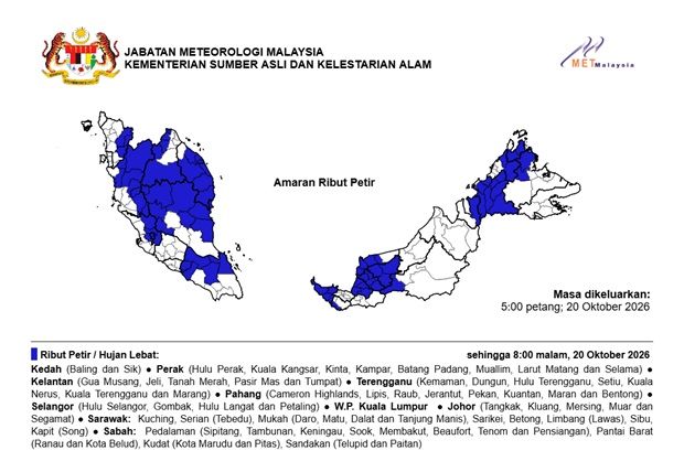 MetMalaysia: Thunderstorms, severe weather expected in nine states and KL until 8pm on Oct 20
The Star MetMalaysia: Thunderstorms, severe weather expected in nine states and KL until 8pm on Oct 20 PETALING JAYA: Thunderstorms and heavy rains are expected in several states in the country until 8pm on Tuesday (Oct…
-
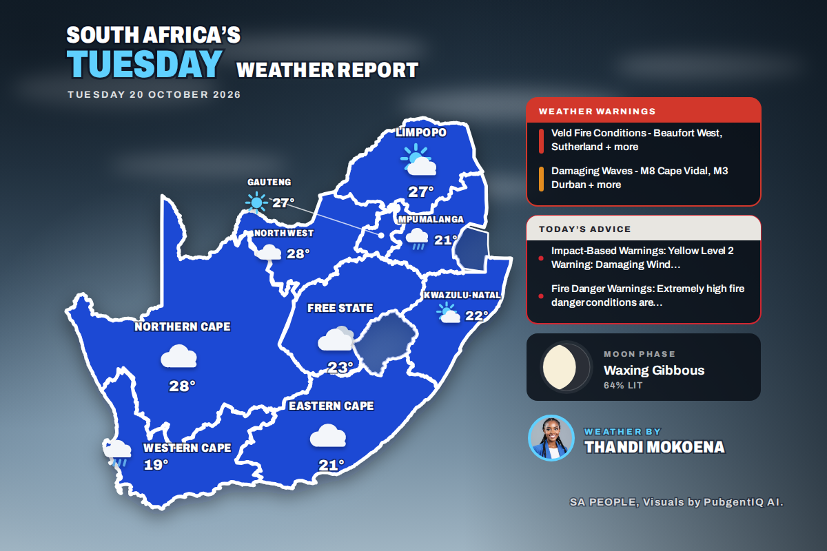 Here is today’s weather by province: Damaging waves expected along the KwaZulu-Natal coast today
Home » Here is today’s weather by province: Damaging waves expected along the KwaZulu-Natal coast today Mahikeng swings from a chilly 6°C at dawn to the country’s warmest reading of 28°C, while Cape Town tops out at…
- Sunny Sunday With Passing Clouds as Temperatures Stay Below Average
Cyprus will enjoy mainly sunny weather on Sunday, although periods of increased cloud cover are expected at times. Winds will be southwesterly to northwesterly, ranging from light to moderate at 3-4 Beaufort…
-
 Warmer weather, local showers forecast across Greece
Greece is forecast to see generally fair weather Sunday, with clouds increasing in some areas from midday, according to the National Meteorological Service. Isolated showers are possible in eastern Macedonia, Thrace and…
-
 Weather forecast for October 18, 2026: Northern Vietnam to experience hot weather before a cold front arrives.
Latest weather forecast news for today (October 18, 2026). Get the fastest and most accurate weather forecast updates on Nguoi Dua Tin. According to the National Center for Meteorological and Hydrological Forecasting…
-
 Thunderstorms and heavy rain forecast for 13 states, KL and Putrajaya until 5pm
PETALING JAYA: The Malaysian Meteorological Department (MetMalaysia) has issued a warning of thunderstorms, heavy rain and strong winds across 13 states and two Federal Territories, effective until 5pm on Saturday (Oct…
- Cloud, Showers and Gusty Winds Forecast Across Cyprus
A weak low-pressure system is affecting the island, while a weak high-pressure system is expected to move in from Sunday. According to the forecast, periods of increased cloud cover are expected throughout Saturday…
- Weather alert for winds in Lowcountry until Saturday evening
Hilton Head Island Packet The creation of this content included the use of AI based on templates created, reviewed and edited by journalists in the newsroom. Read more on our AI policy here. The NWS Charleston SC issued…
-
 Storm impacts begin to wind down in Southeast, but flooding and landslide risk still remains
Alaska's News Source ANCHORAGE, AK (Alaska’s News Source) - As of Friday morning, rain accumulations in some Southeast locations have climbed to over 4 inches in just 48 hours. More rain is ahead through today in…
-
 Rain, Storms and Falling Temperatures Sweep Across Greece
Why do two in three Greeks “hate” Athens? What does the Metron Analysis poll reveal about quality of life, stress and crime in the Attica region? A new spell of unsettled weather is moving across Greece, bringing…
Air quality
Acceptable. Unusually sensitive people should consider limiting prolonged outdoor exertion.
Savannah, GA reporting area · 1 hr ago. Data from AirNow (EPA and its state, local and tribal partners); preliminary and subject to change.
Sun & moon
Almanac
MonthlyBeaufort Mcas, records since 1945. Normals 1991–2020. Data from NOAA's Regional Climate Centers (ACIS).
Nearby
- Savannah 56 km
- Hilton Head Island 27 km
- Hilton Head 25 km
- Bluffton 28 km
- Wilmington Island 56 km
- Port Royal 6 km
- Rincon 55 km
- Garden City 58 km
- Port Wentworth 56 km
- Burton 5 km
- Whitemarsh Island 55 km
- Laurel Bay 11 km
Forecasters' discussion
From the National Weather Service office in CHS, issued 4 hrs ago
What Has Changed
Former Key Message 2 has been removed as the High Rip Current Risk has expired, and the aviation section has been updated.
Key Messages
- 1) Below normal temperatures this week as high pressure prevails and a powerful nor'easter meanders off the Mid- Atlantic coast.
- 2) The highest astronomical tides of 2026, combined with near gale force northeast winds, will bring a multi-day coastal flooding threat to SE GA and SC Lowcountry this weekend, with elevated water levels lingering through most of next week.
Discussion
KEY MESSAGE 1: Below normal temperatures this week as high pressure prevails and a powerful nor'easter meanders off the Mid-Atlantic coast.
Surface dewpoints have mixed to around 40 degrees across the forecast area this afternoon. The clear and dry conditions will remain across the forecast area through early this evening. During the mid to late evening, thin mid and high clouds sourced from over the southern Appalachians will drift over the SC Lowcountry later this evening through the overnight hours. The sky across SE GA should remain mostly clear. Given thin cloud cover, light winds, and dry conditions, low temperatures should favor the cooler MOS solutions. Min temperatures are forecast to range from the mid 40s inland to the 50s across the beaches.
Wednesday through Thursday: A nor'easter will be positioned well off the coast of the Mid-Atlantic states Wednesday morning. It will slowly meander slightly further away from the Mid-Atlantic states into Thursday evening. Across the southeastern states high pressure will hold strong both days, centered over the Great Lakes. The prevailing high pressure will yield dry and sunny conditions over the local forecast area with high temperatures in the 70s. Overnight both Wednesday and Thursday nights winds are forecast to go light to calm, resulting in prime radiational cooling conditions. Lows both nights will be several degrees below normal, with lows bottoming out in the mid 40s inland and low 50s along the beaches.
Friday through Monday: With the nor'easter drifting further away from the Mid-Atlantic states, high pressure will begin to build in stronger over the Mid-Atlantic states. Along with the building high pressure, a coastal trough is forecast to develop along the Southeastern coastline. This will yield gusty NE winds across the forecast area, especially along the coast. The advection of cooler air resulting from the NE flow will keep temperatures below normal through the weekend and into early next week.
KEY MESSAGE 2: The highest astronomical tides of 2026, combined with near gale force northeast winds, will bring a multi-day coastal flooding threat to SE GA and SC Lowcountry this weekend, with elevated water levels lingering through most of next week.
Tidal departures will begin to increase as northeast winds strengthen along the coast on Saturday. Minor to moderate coastal flooding is possible for Charleston and coastal Colleton counties Saturday evening. Winds are forecast to strengthen to near gale force on Sunday. Moderate to major coastal flooding is possible for Charleston and Colleton counties, with moderate coastal flooding possible along the southern SC and GA coastlines.
Aviation
No aviation concerns as northerly winds weaken tonight, with 5 to 10 knot north-northeasterly winds expected for Wednesday.
Extended Aviation Outlook: Gusty NE winds upwards of 25 knots are forecast on Saturday.
Forecasts, observations and alerts in the United States come from the National Weather Service (NOAA); radar from NOAA's Multi-Radar Multi-Sensor system; satellite imagery from NASA's Global Imagery Browse Services (GIBS) and NOAA's GOES satellites; the map from the U.S. Geological Survey's National Map; air quality from AirNow (EPA and its partners); hurricane information from the National Hurricane Center; climate normals and records from NOAA's Regional Climate Centers (ACIS). Forecasts outside the United States and the UV index: MET Norway (CC BY 4.0); observations outside the U.S.: airport reports via NOAA's Aviation Weather Center. Place names: GeoNames (CC BY 4.0). Data are copied on a schedule and may lag the sources; for warnings that affect your safety, follow your local National Weather Service office and emergency officials. Weather news is drawn from the 4Search index and reflects what the press published. Terms of use.