Install
Richmond, VA 23261 Weather
Current conditions
Observed at Richmond, Richmond International Airport · 14 min ago
Forecast
10-day-
Today
Sunny, with a high near 68. North wind around 12 mph.
-
Tonight
Clear, with a low around 42. North wind 3 to 9 mph.
-
Thursday
Sunny, with a high near 70. North wind 6 to 10 mph.
National Weather Service forecast updated 2 hrs ago.
Hourly
Hourly forecast- Now62°
- 1 PM64°
- 2 PM66°
- 3 PM67°
- 4 PM67°
- 5 PM65°
- 6 PM63°
- 7 PM58°
- 8 PM54°
- 9 PM52°
- 10 PM50°
- 11 PM49°
- Thu12 AM49°
- 1 AM48°
- 2 AM47°
- 3 AM46°
- 4 AM46°
- 5 AM45°
- 6 AM44°
- 7 AM43°
- 8 AM44°
- 9 AM48°
- 10 AM53°
- 11 AM58°
10-day forecast
Details- TodayOct 21Sunny42°68°
- ThuOct 22Sunny46°70°
- FriOct 23Sunny40°61°
- SatOct 24Sunny43°61°
- SunOct 25Sunny44°66°
- MonOct 26Sunny48°69°
- TueOct 27Sunny49°69°
- WedOct 28Cloudy48°69°
- ThuOct 29Cloudy54°70°
- FriOct 30Cloudy52°75°
Days after the National Weather Service's seven are MET Norway's outlook, a computer model with no forecaster's review.
Radar
Full mapWeather news near Richmond
More weather news- Richmond Basks in Sunny Skies Before a Week of Crisp Fall Breezes
Thursday should reach about 70 before temperatures ease back to 66 Friday, 62 Saturday and around 67 Sunday. Overnight lows could reach the mid-to-upper 30s Wednesday night into Thursday morning in the Piedmont and…
- Crisp Start, Toasty Finish: Richmond Set for Weeklong Warmup
Sunday night stays clear as temperatures fall to around 43 degrees in the city. The breeze should keep frost from forming, even as areas west of Interstate 95 turn colder, according to the National Weather Service…
-
 Breezy with abundant sunshine Sunday
RICHMOND, Va. -- Skies will be sunny today, with a few clouds across southeastern Virginia. It will be breezy with some gusts over 20 mph in central Virginia, and over 30 mph at the coast. Highs will be in the upper 50s…
-
 A soggy start to Saturday
RICHMOND, Va. -- There will be periods of steady rain the first half of today. Temperatures will fall into the upper 40s and lower 50s as the morning wears on. Winds will gust over 30 mph in spots. Rain will turn more…
- Fog, 88 Degrees, Then a 30-Degree Plunge: Richmond Braces for Wild Weather Whiplash
Richmond is starting Friday in fog and mild air, but the city is headed for a summer-like afternoon near 88 degrees. Then comes the weather whiplash: showers and thunderstorms arrive after dark, followed by a windy…
-
 Richmond District weekly traffic alert: October 16, 2026
Virginia Department of Transportation (.gov) Richmond District weekly traffic alert: October 16, 2026 All work is scheduled weather permitting. Updated information on work zones and lane closures is available on…
-

- Record tornadoes, record temps, then maybe frost? Here are today’s top N&O stories
From a record-tying tornado outbreak to a $550 million federal rail investment, here’s a quick look at the stories making headlines from The News & Observer on Thursday, Oct. 15, 2026. Earlier-than-usual frost…
- Richmond Weather: 91 Degrees Wednesday, Cold Weekend Ahead
Richmond gets a sunny, unusually warm Tuesday after early fog, with temperatures climbing from the upper 50s to around 84 degrees. Wednesday turns even hotter near 91 before a sharp Friday night cold front sends weekend…
-
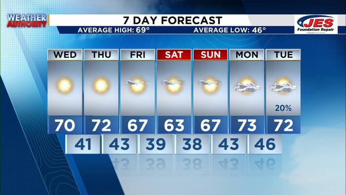 Southwest, Central Virginia Weather | 7 p.m. - Oct. 20, 2026
WSLS Southwest, Central Virginia Weather | 7 p.m. - Oct. 20, 2026 Here's a look at your forecast! Special Olympics Virginia holds 2026 Big Feet Meet 'Build My Future' career event held in Montgomery County for middle…
Air quality
Air quality is satisfactory, and air pollution poses little or no risk.
Forecast
- WedGood (22)
Richmond, VA reporting area · 1 hr ago. Data from AirNow (EPA and its state, local and tribal partners); preliminary and subject to change.
Sun & moon
Almanac
MonthlyRichmond Area, records since 1897. Normals 1991–2020. Data from NOAA's Regional Climate Centers (ACIS).
Nearby
- Tuckahoe 9 km
- Mechanicsville 10 km
- Petersburg 37 km
- Short Pump 17 km
- Hopewell 32 km
- Chester 22 km
- Midlothian 17 km
- Meadowbrook 12 km
- Colonial Heights 32 km
- Laurel 11 km
- Bon Air 9 km
- Highland Springs 12 km
Forecasters' discussion
From the National Weather Service office in AKQ, issued 6 hrs ago
What Has Changed
Temperatures have trended warmer during the day and cooler at night. Added patchy frost to the forecast for portions of the Piedmont early Thursday morning and Friday night into Saturday morning.
Coastal Flood Advisories expanded in area and time. A Coastal Flood Warning was issued for the city of Virginia Beach mainly for the area surrounding the Lynnhaven Inlet tidal gauge.
Key Messages
1) Sunny and dry Fall weather continues.
2) Prolonged onshore flow will lead to multiple elevated tide cycles this week resulting in rounds of coastal flooding.
Discussion
As of 540 AM EDT Wednesday...
KEY MESSAGE 1...Sunny and dry Fall weather continues.
High pressure remains centered north of the local area, centered over interior portions of New England and SE Canada. Meanwhile, a coastal low lingers well offshore. Temps as of 540 AM ranged from the mid to upper 40s for most inland areas and upper 50s to around 60 along the coast. The low has consistently been farther east than models indicated over the past few days. As such, it is difficult to believe that the low will nudge back west at this point into high pressure. Nevertheless, models still try to show the low nudging a bit west today while deepening. Given the uncertainty, have kept the outer cloud shield from the low reaching far eastern portions of the area later this afternoon into this evening before clouds move back over the ocean as the low pulls away tonight. However, even this may be overdone and it is entirely possible that only a portion of the Eastern Shore sees any clouds today with the vast majority of the forecast area likely remaining sunny. Given the trend for sunny conditions today, temps have trended warmer with highs in the mid 60s across the coast as well as the Eastern Shore and upper 60s elsewhere. Temps may even reach 70F in a few locations.
The coastal low moves farther offshore Thu with high pressure gradually building south into the region through the weekend. This will allow for stagnant weather pattern with sunny and dry weather continuing for the foreseeable future. In fact, some model guidance shows completely dry conditions through the end of the month. Temperatures remain seasonable Thu with highs in the upper 60s to around 70F. However, as the cool, strong high builds into the region Fri into the weekend, cooler temperatures arrive with highs in the lower 60s for most Fri and Sat (potentially upper 50s across the Eastern Shore and mid 60s across NE NC). Temperatures moderate back into the mid-upper 60s by Sun and upper 60s to lower 70s Mon and Tue. Meanwhile, lows are expected to range from the upper 30s across the Piedmont and typically cooler locations near I-95 to the lower 40s east of I-95 and around 50F along the coast tonight into Thu morning. As such, some patchy frost is possible across mainly the Piedmont. However, temperatures don't look to be cool enough to support Frost Advisories at this time. The better chance for a more widespread frost is Fri night into Sat morning with the high centered just to the north of the local area. The best chance for frost will once again be across the Piedmont and typically cooler interior portions of the Northern Neck and S/SE VA. Currently have lows that night in the mid-upper 30s across the Piedmont, upper 30s for most inland areas far from the coast, 40s closer to the coast, and lower 50s along the coast. However, given the strength of the high, it is possible that Louisa gets down to around 32-33F. As such will have to monitor trends in case Frost Advisories are warranted. Sat night/Sun morning will also be cool with additional patchy frost possible, however, it will likely not be as cool as Fri night/Sat morning. Otherwise, winds remain breezy mainly along the coast each day through Fri with gusts up to 25-30 mph today and 20-25 mph Thu an Fri. Inland will not be as breezy, however, gusts up to 20-25 mph are possible today with occasional gusts up to around 20 mph possible Thu and Fri.
KEY MESSAGE 2...Prolonged onshore flow will lead to multiple elevated tide cycles this week resulting in rounds of coastal flooding.
The ETSS, PETSS and STOFS continue to suggest the anomalies will continue to increase today with 2-3 ft anomalies expected. This may allow some of the sites more prone to flooding (Lynnhaven, Smithfield, Bayford, etc.) to touch moderate flooding during the high tides later this afternoon/evening and potentially again Thursday AM. The only location with enough confidence for a warning is Lynnhaven, mainly due to the very large swell at the mouth of the Chesapeake Bay likely aiding in the flood potential. Models have trended too high for this entire event so far and the confidence is just not there to issue any additional warnings at this time. Otherwise, extended the Coastal Flood Advisories out another high tide cycle and now have most of them running through locations adjacent to the York and Rappahannock Rivers.
Aviation
As of 540 AM EDT Wednesday...
VFR conditions prevail for the 12z taf period under mostly clear skies. Some cirrus may approach the coast this afternoon into this evening, potentially reaching SBY, ORF, and PHF with the best chance at SBY. If the clouds do push far enough inland, it is possible that stratus reaches SBY as well. However, CIGs are likely to remain VFR even in that scenario. Otherwise, N winds were light early this morning with only ORF and ECG reporting winds above 5 kt (both reporting 10 kt winds). Winds increase by late morning to 10-15 kt with gusts up to 20-25 kt area-wide. Winds will be strongest at the coast with ORF and ECG likely a few knots higher than inland terminals.
Outlook: VFR conditions and daytime breezy N winds are expected to prevail through the rest of the week. Winds become light each night away from the coast.
Forecasts, observations and alerts in the United States come from the National Weather Service (NOAA); radar from NOAA's Multi-Radar Multi-Sensor system; satellite imagery from NASA's Global Imagery Browse Services (GIBS) and NOAA's GOES satellites; the map from the U.S. Geological Survey's National Map; air quality from AirNow (EPA and its partners); hurricane information from the National Hurricane Center; climate normals and records from NOAA's Regional Climate Centers (ACIS). Forecasts outside the United States and the UV index: MET Norway (CC BY 4.0); observations outside the U.S.: airport reports via NOAA's Aviation Weather Center. Place names: GeoNames (CC BY 4.0). Data are copied on a schedule and may lag the sources; for warnings that affect your safety, follow your local National Weather Service office and emergency officials. Weather news is drawn from the 4Search index and reflects what the press published. Terms of use.