Install
Stourbridge, England, United Kingdom Weather
Current conditions
Forecast for this hour (no station report in the last two hours)
Forecast
10-day-
Saturday
Heavy rain. High 14°. Precipitation 14.1 mm for the day.
-
Saturday Night
Heavy rain. Low 6°. Precipitation 14.1 mm for the day.
-
Sunday
Mostly sunny. High 11°.
MET Norway forecast updated 1 day ago.
Hourly
Hourly forecast- Now10°2.4
- 16:0010°2.5
- 17:0011°1.9
- 18:0013°1.4
- 19:0014°0.7
- 20:0014°0.4
- 21:0012°
- 22:0010°
- 23:009°
- Sun00:009°
- 01:009°
- 01:009°
- 02:009°
- 03:009°
- 04:009°
- 05:008°
- 06:008°
- 07:008°
- 08:008°
- 09:009°
- 10:0010°
- 11:0010°
- 12:0011°
- 13:0011°
Daily forecast
DetailsRadar
Full mapWeather news near Stourbridge
More weather news- Birmingham Faces Heavy Rain and Chilly Conditions as Autumn Weather Takes Hold
Home » Trending » Birmingham Faces Heavy Rain and Chilly Conditions as Autumn Weather Takes Hold Birmingham is experiencing persistent downpours today, as a significant band of moisture brings a 95% chance of…
-
 Birmingham weather forecast for October 18, 2026: Sunny intervals with maximum temperature of 11°C
The Times of India Birmingham, October 18, 2026, brings a day of sunny intervals, with the weather shaping up to be quite pleasant for the region Today's maximum temperature will reach 11°C, while the minimum will dip…
-
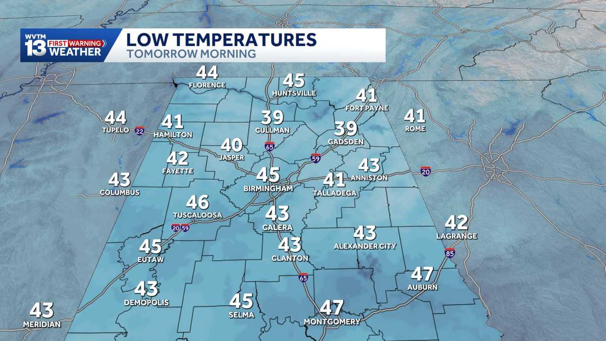 Chilly mornings and sunny, warm days in Alabama's weather forecast this week
MONDAY: Chilly morning lows down in the 40s. Warming up to the 70s with full sunshine in the afternoon. Rain chance: 0%. TUESDAY: Another chilly start in the 40s. Warming to the mid-70s in the afternoon with a light…
-
 First Alert Weather: Sunny, dry week ahead
BIRMINGHAM, Ala. (WBRC) - Happy Sunday! It’s been a sunny and chilly start to the day with temperatures in the 40s. Dry air warms up quickly, and temperatures have rebounded into the lower 60s shortly before noon. It…
- First Alert Weather: Sunny Sunday afternoon
BIRMINGHAM, Ala. (WBRC) - Happy Sunday! We’re seeing the coolest air we have seen so far this fall season across central Alabama. Temperatures are starting out in the low-to-mid-40s. With a light wind, you don’t have to…
-
 UK maps show a wet end to the week for England, before stormier weather develops next week
So far, the weekend has been marked by significantly cooler temperatures across the UK as a high-pressure system has led to a northerly breeze that’s brought an autumn chill across the country. Conditions have also…
-
 First Alert Weather: Chilly temperatures Sunday morning
BIRMINGHAM, Ala. (WBRC) - Good afternoon! It’s been a chilly start to the day with temperatures in the 40s. It will be a breezy day with northerly winds at 10-20 mph. We could see gusts up to 25 mph. Winds should lower…
-
 Alabama’s first freeze dates: When to expect cold weather in north, central and south Alabama
A few cool fall mornings are usually enough to get Alabama gardeners thinking about their tomatoes, the flowers still blooming, and the potted plants on the porch. How much longer can they stay outside? Across Alabama…
-
 First Alert Weather: Breezy, cool Saturday
BIRMINGHAM, Ala. (WBRC) - Good morning and happy Saturday! Fall weather has finally arrived after a long stretch of summer-like temperatures this past week. You’ll need a jacket this morning as temperatures have cooled…
-
 UK Winter Forecast 2026 27 What to Expect This Season
Dhaka, Saturday 17 October 2026 If you are hoping for a guaranteed white Christmas, the science might disappoint you. Long-range weather modelling simply does not work like a crystal ball. Meteorologists cannot tell you…
Sun & moon
Nearby
- Birmingham 17 km
- Coventry 43 km
- Wolverhampton 14 km
- Dudley 6 km
- Walsall 18 km
- Telford 32 km
- Solihull 25 km
- Burton upon Trent 52 km
- Sutton Coldfield 25 km
- West Bromwich 12 km
- Worcester 30 km
- Nuneaton 47 km
Forecasts, observations and alerts in the United States come from the National Weather Service (NOAA); radar from NOAA's Multi-Radar Multi-Sensor system; satellite imagery from NASA's Global Imagery Browse Services (GIBS) and NOAA's GOES satellites; the map from the U.S. Geological Survey's National Map; air quality from AirNow (EPA and its partners); hurricane information from the National Hurricane Center; climate normals and records from NOAA's Regional Climate Centers (ACIS). Forecasts outside the United States and the UV index: MET Norway (CC BY 4.0); observations outside the U.S.: airport reports via NOAA's Aviation Weather Center. Place names: GeoNames (CC BY 4.0). Data are copied on a schedule and may lag the sources; for warnings that affect your safety, follow your local National Weather Service office and emergency officials. Weather news is drawn from the 4Search index and reflects what the press published. Terms of use.