Install
Bexley, England, United Kingdom Weather
Current conditions
Forecast for this hour (no station report in the last two hours)
Forecast
10-day-
Wednesday
Heavy rain. High 13°. Precipitation 3.2 mm for the day.
-
Wednesday Night
Light rain. Low 8°. Precipitation 3.2 mm for the day.
-
Thursday
Showers. High 14°. Precipitation 7.8 mm for the day.
MET Norway forecast updated 20 hrs ago.
Hourly
Hourly forecast- Now12°
- 10:0013°0.3
- 11:0013°
- 12:0012°
- 13:0011°
- 14:0010°0.2
- 15:0010°0.6
- 16:009°1.0
- 17:008°0.7
- 18:008°
- 19:008°
- 20:009°
- 21:008°
- 22:008°
- 23:008°
- Thu00:008°
- 01:007°
- 02:007°
- 03:008°1.5
- 04:008°1.7
- 05:008°0.5
- 06:009°0.4
- 07:009°
- 08:009°
Daily forecast
DetailsRadar
Full mapWeather news near Bexley
More weather news-
 When London's last sunset after 5pm is happening
People across the UK are getting an extra hour in bed next week While the winter nights have slowly been creeping in, London is about to get darker a whole lot earlier later this month. The sun will set after 5pm for…
-
 Forecasters predict major London weather change next week: 'First storm is coming'
Stormy weather appears increasingly likely to sweep London towards the end of October, according to the latest forecasts. The Met Office is predicting gale force winds up to 37mph over the capital on Friday, October 23…
-
 Austin weather: Temps will reach the 80s
FOX 7 Austin Temps will warm back up in Central Texas. Leslie London has the details
- London Faces 43mph Gales as Met Office Warns First Autumn Storm Is Coming
London is bracing for gale-force winds reaching up to 43mph as the Met Office warns an aggressive Atlantic weather pattern is preparing to unleash the season’s first major storm across the capital. Forecasters tracking…
-
 Five ways El Niño is affecting the weather around the world
El Niño has been strengthening for several months now and is already having a significant impact on global weather patterns. Countries including Indonesia, India and the United States have been experiencing droughts…
-
 A warmer Tuesday in Connecticut with a mix of sun and clouds. Here's when the chill sets in again.
Leaves begin to change color at a home on Sport Hill Road in Easton on Oct. 7, 2026. Another day of seasonable fall weather is in store for Connecticut Tuesday — but expect it to be a little cloudier and breezier than…
-
 Met Office issues 12-hour 'danger to life' warning as 38 areas face power cuts
The Met Office has issued a yellow weather warning ahead of strong winds that may cause damage and transport disruption. The warning, in place from midnight until noon on Friday, says strong westerly to northwesterly…
-
 First rain of the season to arrive in Bay Area Tuesday night
SAN FRANCISCO (KRON) -- The first rain of the season is due to arrive in the Bay Area Tuesday night, according to the National Weather Service. The NWS is advising of rain showers continuing through Thursday morning…
-
 Become an Independent member to bookmark this article
Where are Met Office weather warnings in place as 70mph winds forecast? - The Met Office has issued a yellow weather warning for wind covering much of Wales and the south of England, remaining in place until midday on…
-
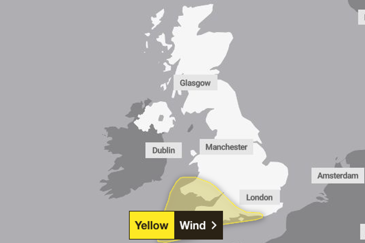 Met Office weather warning issued as 70mph winds set to hit UK this week
Winds of up to 70mph could hit a large part of England and Wales this week, the Met Office has warned. A yellow weather warning for wind has been issued across the south of England and much of Wales for Friday up until…
Sun & moon
Nearby
- London 20 km
- Islington 20 km
- City of Westminster 21 km
- Barking 11 km
- Archway 24 km
- Sutton 26 km
- Croydon 18 km
- Ilford 14 km
- Enfield Town 28 km
- Basildon 26 km
- Tottenham 23 km
- Walthamstow 20 km
Forecasts, observations and alerts in the United States come from the National Weather Service (NOAA); radar from NOAA's Multi-Radar Multi-Sensor system; satellite imagery from NASA's Global Imagery Browse Services (GIBS) and NOAA's GOES satellites; the map from the U.S. Geological Survey's National Map; air quality from AirNow (EPA and its partners); hurricane information from the National Hurricane Center; climate normals and records from NOAA's Regional Climate Centers (ACIS). Forecasts outside the United States and the UV index: MET Norway (CC BY 4.0); observations outside the U.S.: airport reports via NOAA's Aviation Weather Center. Place names: GeoNames (CC BY 4.0). Data are copied on a schedule and may lag the sources; for warnings that affect your safety, follow your local National Weather Service office and emergency officials. Weather news is drawn from the 4Search index and reflects what the press published. Terms of use.