Install
Pacé, Brittany, France Weather
Current conditions
Observed at Rennes/St Jacques Arpt · 1 hr ago
Forecast
10-day-
Tuesday
Mostly sunny. High 15°. Precipitation 2.2 mm for the day.
-
Tuesday Night
Heavy rain. Low 10°. Precipitation 2.2 mm for the day.
-
Wednesday
Cloudy. High 13°. Precipitation 2.4 mm for the day.
MET Norway forecast updated 2 hrs ago.
Hourly
Hourly forecast- Now13°
- 19:0012°
- 20:0010°
- 21:0010°
- 22:0010°0.7
- 23:0010°1.4
- Wed00:0010°0.2
- 01:0010°2.0
- 02:0011°0.2
- 03:0012°
- 04:0011°
- 05:0010°
- 06:0010°
- 07:0010°
- 08:0010°
- 09:009°
- 10:0010°
- 11:0011°
- 12:0012°
- 13:0013°
- 14:0013°
- 15:0013°
- 16:0013°
- 17:0013°
10-day forecast
DetailsRadar
Full mapWeather news near Pacé
More weather news- Great fall weather all week
It has been another beautiful October day today, with sunny skies and temperatures in the 60s. This week there really is not much going on other than some gorgeous weather. We will be under upper-level ridging and that…
-
 A very quiet and unfall-like week ahead
MADISON, Wis. (WMTV) - Sunshine is sticking around for the rest of Sunday afternoon across southern Wisconsin, with temperatures climbing into the lower and mid-60s. Madison should reach around 62 degrees, a noticeable…
-
 Is your low tire pressure light on? Here's why the chilly Texas weather is to blame.
After a cold font blew through the region Friday evening, Southeast Texas is now experiencing its coldest temperatures since early April. Lows fell into the 40s and 50s early Saturday morning, and a similarly chilly…
-
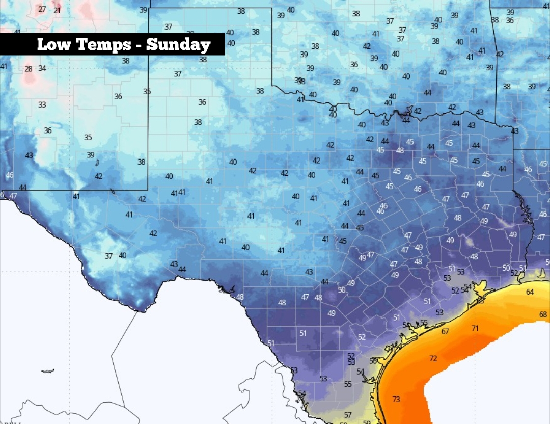 Low tire pressure? Here’s why the colder Texas weather is to blame.
Shown are the expected low temperatures across Texas on Sunday morning After a cold font blew through the region Friday evening, Southeast Texas is now experiencing its coldest temperatures since early April. Lows fell…
-
 IMD update: Chennai drenched as Bay of Bengal and Arabian Sea brace for more activity
The north-east monsoon has gathered pace over the South Peninsula, with rain-bearing systems firing on both flanks and the Arabian Sea preparing to join action with a possible low-pressure area of its own. India…
-
 FIRST ALERT: Front moves through. AM showers possible. Breezy and cooler is the theme.
CHARLESTON, S.C. (WCSC) — Sharply cooler temperatures are expected this weekend as a cold front moves across the Lowcountry! The aforementioned front remains on pace to move across the region this morning. As it does…
-
 Temps drop into the 40s for the first time in months
KXXV Bring on the Fall weather! This is a much-welcomed change of pace for Central Texas, with temperatures in the 60s on Friday While the winds gusted up to 45mph, Wind Advisories will expire at 7 pm for Central Texas…
-
 January’s ‘snowcrete’ part of DC’s planning for another possibly brutal winter
The D.C. government isn’t expecting the region to be buried again under a layer of rock-hard “snowcrete” this winter. But officials are preparing as if it could be. “Who can forget the historic, unique and complex…
-
 Severe Thunderstorm Watch: Washington DC, Maryland And Northern Virginia Face Threat Of Damaging Winds And Heavy Rain; Check Affected Areas And Forecast Timing
Zaini is Editor at The Sunday Guardian. She focuses on geopolitics, defence, international affairs, and breaking news coverage. She has worked in fast-paced newsrooms, including WION, Republic Media Network, India Today…
-
 Ice Cleats for Shoes: What Rockland Residents Should Know Before the First Freeze
This guide explains how ice cleats work, how to choose a pair, how to use them safely and what the published safety guidance says about walking on ice and snow. Ice cleats are traction devices that stretch over or strap…
Sun & moon
Nearby
- Rennes 9 km
- Saint-Malo 58 km
- Fougères 48 km
- Vitré 42 km
- Cesson-Sévigné 13 km
- Bruz 14 km
- Châteaubriant 56 km
- Dinan 40 km
- Dinard 58 km
- Redon 60 km
- Betton 10 km
- Saint-Jacques-de-la-Lande 10 km
Forecasts, observations and alerts in the United States come from the National Weather Service (NOAA); radar from NOAA's Multi-Radar Multi-Sensor system; satellite imagery from NASA's Global Imagery Browse Services (GIBS) and NOAA's GOES satellites; the map from the U.S. Geological Survey's National Map; air quality from AirNow (EPA and its partners); hurricane information from the National Hurricane Center; climate normals and records from NOAA's Regional Climate Centers (ACIS). Forecasts outside the United States and the UV index: MET Norway (CC BY 4.0); observations outside the U.S.: airport reports via NOAA's Aviation Weather Center. Place names: GeoNames (CC BY 4.0). Data are copied on a schedule and may lag the sources; for warnings that affect your safety, follow your local National Weather Service office and emergency officials. Weather news is drawn from the 4Search index and reflects what the press published. Terms of use.